Forecast for the Salt Lake Area Mountains

Evelyn Lees
Issued by Evelyn Lees for
Friday, February 15, 2019
It will be day of increasing avalanche danger, with natural avalanches possible this afternoon and tonight as winds increase and heavy snowfall occurs.
This morning - the avalanche danger is CONSIDERABLE on steep slopes at the mid and upper elevations, especially those recently drifted with snow. Considerable means human triggered avalanches are likely, and careful snowpack evaluation, cautious route finding and conservative decision making are necessary for backcountry travel. Watch for avalanches sliding off roofs. Be especially watchful of kids playing near any house with a large load of snow on the roof.
This afternoon - the avalanche danger will increase to HIGH when the winds strengthen and tonight during periods of heavy snowfall.

Turning and riding will be excellent on the untracked, classic wind sheltered, low angle terrain the Wasatch has so much of. (slopes less steep than about 30 degrees and above about 8,000')
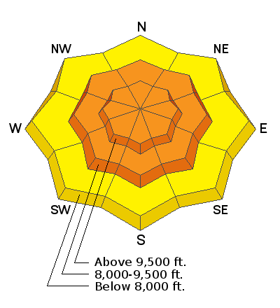
Low
Moderate
Considerable
High
Extreme
Learn how to read the forecast here
Special Announcements
The accident reports for the four avalanche fatalities are all finalized with some first-hand accounts and worth reading. We all have something to learn so that we can get home safely to our loved ones.
Jan 18 Electric Lake Accident (Skyline area)
Jan 25 Laurel Peak Accident (Moab area)
Feb 7 Circleville Mtn Accident (Southwest area near Beaver, UT)
Feb 9 Chalk Creek Accident (Western Uintas)

The latest UAC Podcast was just released: The Message and the Messengers - A Conversation with Alex Hamlin. In this podcast, we sit down with Alex Hamlin. For over fifteen years, Alex Hamlin has worked at the intersection of storytelling and outdoor sport, with experience at magazines, global retail brands and creative agencies....
Weather and Snow
Another wave of snow overnight brought 5 to 7” of snow to the Salt Lake and Park City area mountains (containing 1 - 1.2” of water). Storm totals are now 18 to 21” of snow, containing up to 3” of water. The rain/snow line started near 8,000’ last night, but rapidly dropped with the arrival of cold air. Temperatures have dropped about 10 degrees in the past 12 hours, and are currently in the teens and low 20s. Winds are from the southwest, and averaging 10 to 15 mph, with the high peaks 25 to 35 mph, gusting 45 to 55 mph.
Today and tonight: increasing clouds, with light snow starting this afternoon. Increasing southwesterly winds by early afternoon - 20 mph averages with gusts to 30 at about 9,000’ and 35 mph averages, with gusts in the 60s across the highest peaks. Tonight - strong winds and heavy snow, with totals of 10 to 18” possible by Saturday evening.
Recent Avalanches
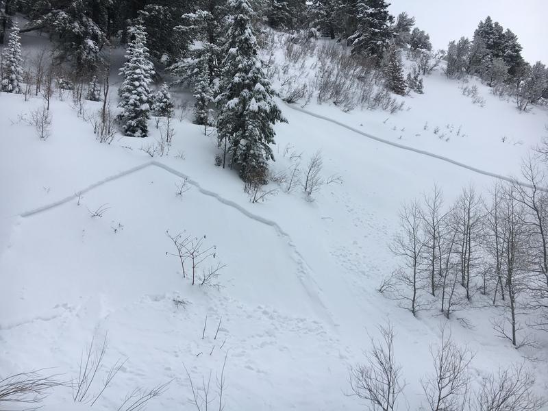
Yesterday started out with a wet snow avy cycle, of both soft slabs and sluffs. These were below about 8,000’, and limited to new snow only. I expect it repeated again last night.
The upper elevations also had a natural cycle, including multiple impressive slides in east facing Honeycomb (100-200’ wide, 1 to 3 feet deep), upper Cardiff and Hidden Canyon. There were 2 artillary triggered very large slides in the south facing paths in Little Cottonwood. In addition, there were numerous explosive triggered slides at the resorts, mostly new snow only, but definitely large enough to bury a person. Wind loaded slopes and graupel pools mid slopes and at cliff bases were active, with slides fast and long running.
Butler Fork trailhead natural avalanche (7200') , Craig Gordon photo
Ad
Avalanche Problem #1
New Snow
Type
Location
Likelihood
Size
Description
At the mid and upper elevations, above about 8,000’, new snow slides one to two feet deep can be triggered on steep slopes, failing on density inversions or graupel. The graupel pools below cliff bands and at the base of gullies, and on slightly lower angle slopes than you would expect.
At low elevations, below about 8,000’, you can still trigger wet loose sluffs and shallow new snow avalanches resulting in wet debris. It will take a day for all the wet snow to cool, so avoid steep slopes and especially terrain traps such as creek beds, gullies and road banks, where even a small slide can result in a deep pile of cement like debris. This includes steep, snow covered roofs at all elevations.
Avalanche Problem #2
Wind Drifted Snow
Type
Location
Likelihood
Size
Description
Old wind slabs: The old, harder wind drifts are now hidden beneath the new snow, and are more stubborn, likely to break above you or on the second or third person. It maybe possible to trigger these drifts from a distance or from below.
New wind slabs: New drifts formed overnight as the westerly winds blew the new snow. Winds are forecast to increase this afternoon, with plenty of snow to drift into new sensitive wind slabs. Watch for plumes off the high peaks and blowing snow where you are. Once the snow start to move, the avalanche danger will rise. The sensitive new wind drifts will deepen and become more widespread. Time to dial it back and get off of and out from under any wind drifted slopes. Plan your back country day with a good exit.
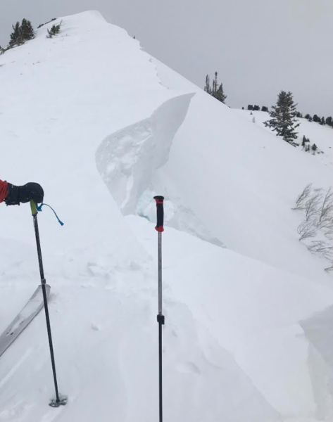
Cornices are HUGE! And they are breaking back much further than expected. However far you think you need to be back from the edge, then take an extra several steps even further back.
Butler Basin ridge line
Avalanche Problem #3
Persistent Weak Layer
Type
Location
Likelihood
Size
Description
With back to back big storms and wind, deep slides can still break near the ground and I can’t wish them away. I expect a few of these monsters to be triggered every day as long as the storms keep rolling in. It will probably take larger triggers, like explosives, big cornice failures or multiple people on a slope. But in isolated places, a person entering a slab from a thinner edge could trigger a deadly slide. Shallower snow pack areas - such as steep, rocky slopes, wind scoured areas that have never developed a deeper snow pack, and especially repeater slopes that have avalanched earlier this season are most suspect. With so many days of snow and wind, avoiding steep big slopes and bowls til we get a longer break in the weather.
General Announcements
This information does not apply to developed ski areas or highways where avalanche control is normally done. This forecast is from the U.S.D.A. Forest Service, which is solely responsible for its content. This forecast describes general avalanche conditions and local variations always occur.