Forecast for the Salt Lake Area Mountains

Drew Hardesty
Issued by Drew Hardesty for
Saturday, February 13, 2021
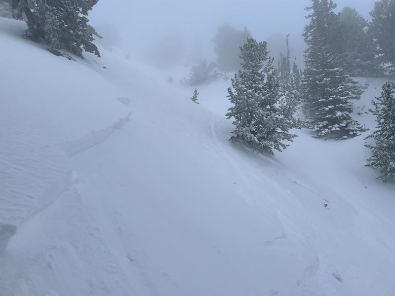
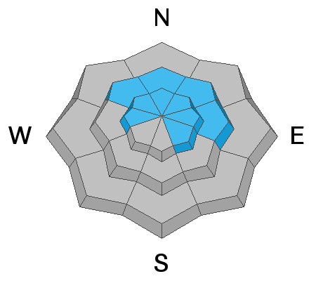
The avalanche danger is CONSIDERABLE on all aspects at the mid and upper elevations. On aspects facing west through north through southeast, very large and dangerous avalanches breaking down 3-5'+ are possible at the mid and upper elevations. The avalanche danger is MODERATE at low elevations.
Travel Advice: avoid being on or beneath steep slopes. The low angle terrain is riding well.
Stay alert for rapidly-changing avalanche conditions as the avalanche danger may rise to HIGH today during any period of heavier precipitation.
Low
Moderate
Considerable
High
Extreme
Learn how to read the forecast here
Avalanche Watch
DANGEROUS AVALANCHE CONDITIONS ARE EXPECTED THROUGH THE WEEKEND.
THE WATCH IS FOR ELEVATED AVALANCHE DANGER IN THE BACKCOUNTRY BEGINNING SATURDAY MORNING AND LASTING THROUGH THE HOLIDAY WEEKEND
FOR ALL THE MOUNTAINS OF NORTHERN UTAH INCLUDING THE WASATCH RANGE.....UINTA MOUNTAINS...MANTI SKYLINE.
AN AVALANCHE WARNING HAS BEEN ISSUED FOR THE LOGAN AREA MOUNTAINS AND THE BEAR RIVER RANGE.
HEAVY SNOW WILL CREATE WIDESPREAD AREAS OF UNSTABLE SNOW. BOTH HUMAN TRIGGERED AND NATURAL AVALANCHES WILL BECOME LIKELY. STAY OFF OF AND OUT FROM UNDER SLOPES STEEPER THAN 30 DEGREES.
Special Announcements
The final report about the Wilson Glade avalanche in Millcreek Canyon has been published. Our deepest condolences go out to the friends and families involved in this tragic accident.
NOTE: FEB 1-8th was one of the deadlier weeks on record with 15 backcountry fatalities in the US.
Dangerous avalanche conditions still exist.
Weather and Snow
Skies are overcast.
Mountain temperatures are in the 20s.
Winds aloft are 15-20mph and backing to the west-southwest ahead of the next approaching storm.

With a couple inches of new overnight, storm totals are
LCC: 13"/1.36" SWE
BCC: 12"/1.2"
Park City ridgeline: 8"/1.0"

Snowfall on a southwest flow should fill in this morning and continue with the trough axis moving overhead this afternoon. Winds will shift to the northwest and north with snowfall continuing overnight.
Watch for periods of heavy snowfall today. We may see upwards of 8-14" by early evening and a bit more overnight. A stronger storm accompanied by strong wind arrives Monday/Tuesday.
Recent Avalanches
Backcountry skiers and riders found sensitive new snow and wind slab avalanches in steep terrain at the mid and upper elevations on all aspects yesterday. Natural avalanches also ran during one if not two periods of higher snowfall intensities with one more widely propagating 500' wide in the Brighton periphery. Most of these soft slab avalanches were 8-16" thick. Shooting cracks were the rule and not the exception.
Ski area avalanche teams triggered similar avalanches with ski cuts and explosives with one notable step down into old rotten layering in McDonald Draw along the Park City ridgeline. This avalanche was on a northeast facing slope at roughly 9700' and pulled out 3-5' deep and 250' wide.
Mitch Potter photo

Our Week in Review - where we highlight significant avalanche and snow events for the past week - is published.
Ad
Avalanche Problem #1
Persistent Weak Layer
Type
Location
Likelihood
Size
Description
You can still trigger deep and destructive avalanches 3-5'+ deep and hundreds of feet wide. The most suspect terrain includes mid and upper elevation west to north to southeast facing slopes. These may not be the most widespread avalanche activity you'll see today, but these will be unsurvivable and will snap trees.
These type of avalanches are most pronounced in steep, thin rocky terrain...and areas that have previously avalanched this winter. They may be more prevalent along the the Park City ridgeline, upper Mill Creek, upper American Fork, and the Snake Creek drainages.
Keep in mind:
  • Existing tracks on the slope offer zero signs of stability.
  • Avalanches can be triggered from a distance or below.
  • Any fresh wind slab or new snow avalanche may step down several feet into older snow.
Forecaster Note: Lower elevation shady aspects and higher elevation solar aspects also harbor varying degrees of weak snow and may be put to the test over the next several days. Uncertainty should lead to greater margins of safety.
Avalanche Problem #2
New Snow
Type
Location
Likelihood
Size
Description
Watch for increased sensitivity during any periods of heavy snowfall. During these times, natural soft slab avalanches will be possible and may even step into yesterday's storm snow, producing significantly larger avalanches. All aspects will be suspect and it may be possible to trigger these at a distance during high rates of snowfall. Yesterday's lingering wind drifts may still be sensitive to provocation at the mid and upper elevations.
Lastly, pay attention to cornices. Cornices are developing along many ridgelines and we have seen a few avalanches triggered from cornice falls. Be sure to give cornices a wide berth as they typically break much further back than expected and could trigger a much larger avalanche below.
General Announcements
Please visit this website with information about Responsible Winter Recreation by the Utah Office of Outdoor Recreation.

This information does not apply to developed ski areas or highways where avalanche control is normally done. This forecast is from the U.S.D.A. Forest Service, which is solely responsible for its content. This forecast describes general avalanche conditions and local variations always occur.