Sign Up for the Utah Snow and Avalanche Workshop (USAW) on December 7th!

Forecast for the Salt Lake Area Mountains

Trent Meisenheimer
Issued by Trent Meisenheimer on
Saturday morning, February 12, 2022
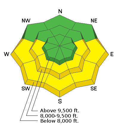
This morning the avalanche danger will be LOW and may rise to MODERATE for the possibility of wet snow avalanche problems due to daytime heating and direct sunlight. I would avoid steep, shallow slopes that become wet, saturated, and unsupportable to the weight of a rider.
Outside of any wet snow avalanche problems, the snowpack is generally stable, and the avalanche danger is LOW. Watch for (1) isolated pockets of wind-drifted snow in exposed terrain at the upper elevations and (2) sluffing in the snow in steep terrain.
Low
Moderate
Considerable
High
Extreme
Learn how to read the forecast here
Special Announcements
Join the Utah Avalanche Center TODAY! Saturday, February 12th, at the Brighton Beacon Bash hosted by Weston Backcountry, Utah Mountain Adventures, Black Diamond, and Ortovox. FREE ski and splitboard demos, avalanche rescue gear demos, and LIVE mock avalanche rescue.
Access to Scotts Pass, West Scotts, and Pinecone Ridge will be closed today as Park City Ski Patrol does work in the area.
Weather and Snow
Under clear skies, the mountain temperatures range from 15-25 °F across the range. Winds are from the northwest and are blowing 5-10 mph, with some anemometers recording gusts into the 20's at the upper elevations. Expect plenty of sunshine today with a few high thin clouds streaming overhead. Mountain temperatures will climb into the 30's and low 40's °F this afternoon. Winds will stay from the northwest and will continue to blow at speeds of 5-10 mph, with the possibility of being a bit gustier this afternoon.
The big weather picture is that we will have warm air advection along with sunny skies over the weekend as a splitting trough moves closer to Utah. This means, at 10,000' in elevation, the mountain temperatures will be warming from 23 °F to 32°F. Bring your flip-flops - it's beach season!
The midweek storm continues to look splitty but the second trough may bring some new snow and refresh the northern mountains. Stay tuned.
Recent Avalanches
No new avalanches were reported.
Greg Gagne's Week in Review is published and can be found HERE>
Ad
Avalanche Problem #1
Wet Snow
Type
Location
Likelihood
Size
Description
As the temperatures warm over the next couple of days, it wouldn't hurt to be thinking about some wet snow problems. I would avoid areas where the snowpack is shallow (less than 3 feet deep) and becomes fully saturated, wet, and unsupportable to the weight of a rider.
The most suspect terrain would be outside the Cottonwoods, such as PC ridgeline, Lambs, Mt Aire, Sessions, Mill Canyon Peak, and Snake Creek. As always, if the snowpack becomes unsupportable and you're seeing active rollerballs cascading down the hill, it's time to get out of there.
One of our colleagues running the snow safety program at one of the ski areas along the Park City ridgeline closed off some of his solar low/mid-elevation terrain yesterday, noting that "the shallow snowpack did not take the heat well." It was time to pull the plug with collapsing the wet snowpack and minor wet loose activity—a good rule of thumb for those traveling in sunny terrain today.
Avalanche Problem #2
Normal Caution
Type
Location
Likelihood
Size
Description
Outside of any wet snow related problems, the snowpack is generally stable and natural and human-triggered avalanches are unlikely. You may encounter
  • FRESH pockets of hard slab along exposed ridges and in open terrain at the upper elevations. Although any drifts will be shallow and not very wide, wind drifts will be sensitive if they have formed on top of weaker snow underneath.
  • Fast and long-running sluffs in the weak, cohesion-less surface snow on steep slopes on shady aspects. In confined and sustained terrain features, sluffs can pile up deeply, especially in terrain traps. On slopes where the weak snow at the surface rests on top of hard crusts, getting caught and carried in a loose sluff could have serious consequences in steep, rocky terrain as you may be unable to self-arrest on any slick surfaces underneath.
General Announcements
Who's up for some free avalanche training? Get a refresher, become better prepared for an upcoming avalanche class, or just boost your skills. Go to https://learn.kbyg.org/ and scroll down to Step 2 for a series of interactive online avalanche courses produced by the UAC.
This information does not apply to developed ski areas or highways where avalanche control is normally done. This forecast is from the U.S.D.A. Forest Service, which is solely responsible for its content. This forecast describes general avalanche conditions and local variations always occur.