Forecast for the Salt Lake Area Mountains

Drew Hardesty
Issued by Drew Hardesty for
Tuesday, February 12, 2019
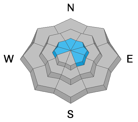
The avalanche danger will rise toward the upper end of MODERATE on wind drifted slopes at upper elevations and lower, mid and upper elevation slopes facing the southern half of the compass. Human triggered avalanches are possible.
  1. New and old wind drifts can be triggered on all steep upper elevation slopes.
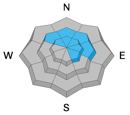
  2. Keep an eye on solar aspects with daytime heating.
  3. Avoid being on and below heavily corniced ridgelines.
  4. There remains the isolated chance of triggering a deeper avalanche, especially in shallow snowpack areas.
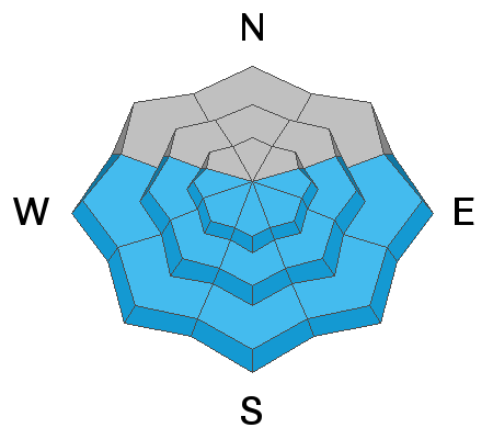
The best and safest riding conditions exist on low angle wind and sun sheltered terrain.
Low
Moderate
Considerable
High
Extreme
Learn how to read the forecast here
Special Announcements
There have now been four avalanche fatalities in four weeks in Utah. On Sunday, UAC staff investigated the avalanche that took the life of 49-year-old Jason Lyman. Find the avalanche report HERE.
Weather and Snow
Yesterday was a beautiful day in the mountains with great riding conditions found on sheltered slopes. Moderate southwesterly winds drifted some snow onto NW-N-NE-E facing slopes. Solar aspects were warmed by mid-afternoon producing rollerballs.
This morning, weather stations are reporting temperatures in the mid-teens, with winds out of the southwest at 10-25 mph. Today we'll see temperatures gradually increasing into the upper 20's and winds increasing into the 30's by early afternoon.
Starting tomorrow we'll move back into an active weather pattern with a series of storms starting off wet and warm. Rain snow line will hover around 7500' Avalanche danger will be on the rise over the next several days.

Today's forecast written by UAC program manager Bo Torrey and approved by Drew Hardesty.
Recent Avalanches
Ski areas reported wind slab activity in isolated terrain. UDOT reported natural activity in lower Little Cottonwood Canyon North Facing chutes such as Y Couloir and Y-Not.
Ad
Avalanche Problem #1
Wind Drifted Snow
Type
Location
Likelihood
Size
Description
Today, the southwesterly winds will continue to drift snow at upper elevations. These will look rounded and pillowy and be reactive to ski cuts. Remember even a small avalanche in consequential terrain can be fatal.
Avalanche Problem #2
Wet Snow
Type
Location
Likelihood
Size
Description
Sun will be out today and temperatures will gradually warm into the upper 20's. Keep an eye on sunlit slopes. If the snow becomes damp or you start to see roller balls it time to change aspects.
Avalanche Problem #3
Persistent Weak Layer
Type
Location
Likelihood
Size
Description
There are two persistent weak layers of concern.
1. Weak surface snow and patches of surface hoar that were buried Saturday, February 2nd are slowly strengthening. Yes, we are seeing these layers gain strength. However, we just received another load of new snow with strong winds. It remains possible one could still trigger an avalanche on this layer. It would be 2-4' deep, most likely on a wind drifted northwest to easterly facing slope, with elevations from 8500' to 10,500'. Slides failing on faceted weak layers can be triggered from a distance, including from below on lower angle slopes.
2. Sunday nights wind and new snow continue to load the deep weak layers in the snowpack, layers which continue to produce isolated avalanches down near the ground 3'-6' deep. While more likely to occur on slopes that have avalanched previously, two of last Friday’s explosive triggered slides were on slopes that had not slid this winter. These deep slides may require more of a significant trigger, perhaps a wind slab stepping down or cornice fall.
Odd areas with traditionally a more shallow snowpack such as Neffs, Lambs, parts of Mill Creek, and the Park City ridgeline are more suspect. Avoid traveling below corniced ridgelines, if a cornice were to break off it's possible that it could pack the punch needed to trigger one of these.
General Announcements
This information does not apply to developed ski areas or highways where avalanche control is normally done. This forecast is from the U.S.D.A. Forest Service, which is solely responsible for its content. This forecast describes general avalanche conditions and local variations always occur.