Forecast for the Salt Lake Area Mountains

Trent Meisenheimer
Issued by Trent Meisenheimer for
Monday, February 11, 2019
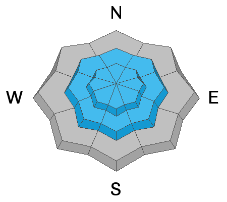
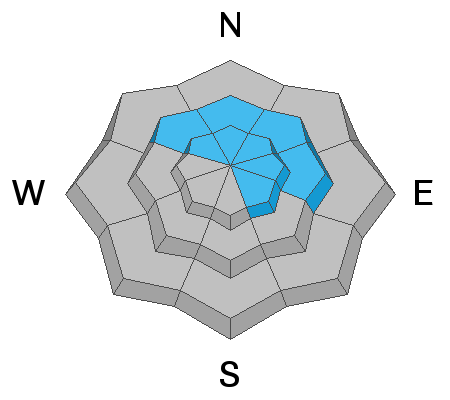
The avalanche danger is CONSIDERABLE on and below steep, wind drifted slopes at all upper elevations. Human triggered avalanches are likely and natural avalanches may be possible.
  1. New and old wind drifts can be triggered on all steep upper elevation slopes.
  2. Avoid being on and below heavily corniced ridgelines.
  3. Watch for new snow soft slabs and sluffs in steep terrain.
  4. There remains the isolated chance of triggering a deeper avalanche, especially in shallow snowpack areas.
Wind sheltered, mid elevation terrain has a MODERATE danger with 5 star turning and riding conditions on slopes under about 35° degrees.
Low
Moderate
Considerable
High
Extreme
Learn how to read the forecast here
Special Announcements
There have now been four avalanche fatalities in four weeks in Utah. Yesterday, UAC staff investigated the avalanche that took the life of 49 year old Jason Lyman. Find the avalanche report HERE.
Weather and Snow
Yesterday, the brutal southwest winds finally gave way as a classic Utah cold front sliced over northern Utah around 3:00 pm. Winds switched to the northwest and snow began falling in the afternoon. 24 hour storm totals are 19.5" snow (1.28" h20) in upper Little Cottonwood. Upper Big Cottonwood picked up 26" of snow (1.48" h20). Park City Ridge 6-12" snow (0.70-1.0" h20). Riding conditions will be five stars out of five today!
Winds this morning are from the west-north-west and currently blowing 5-15 mph with gusts into the 20's across the highest peaks and ridge lines. Mountain temperatures are frigid with upper elevation thermometers reading -3°F. Mid elevation trail heads are in the single digits.
For today, we will see increasing clouds at times and may be some clearing mid morning before the clouds build back in. Winds will back to more of a westerly direction and should be well behaved with speeds in the 10-20 mph range at upper elevations. Temperatures will warm into the low to mid 20's °F. Light snow is possible in favored locations but, not adding up to much. At times the sparkly magic show will begin as the sun lights up the low density six sided dendrites falling from the atmosphere.
Recent Avalanches
No avalanches were reported in the backcountry yesterday. However, there was one report of natural avalanche that likely occurred overnight on the 9th from the strong southerly winds. North facing Murdock Peak 2' feet deep 250' wide and ran 600' feet downhill (Andy Paradis observation HERE).
Ad
Avalanche Problem #1
Wind Drifted Snow
Type
Location
Likelihood
Size
Description
Southerly winds wreaked havoc on the mountains yesterday. Upper elevation averages were in the 20-25 mph range with gusts into the 40's and 50's. To complicated the issue, all of yesterday's wind drifts are now buried and impossible to see due to the overnight storm snow. My advise would be to think like the wind and avoid areas where strong southerly winds could have loaded slopes yesterday. Or, even better - just avoid all steep upper elevation slopes for today and let the snow settle and gain some strength.
Today's, winds will be strong enough to grab the storm snow and form new drifts of wind blown snow and start forming slab avalanches. Look for and avoid any new drifts of wind blown snow. If the snow is cracking under your skis, board or sled, this is a sign of instability.
Avalanche Problem #2
New Snow
Type
Location
Likelihood
Size
Description
Yesterday, observers noted the new snow was failing easily within the new storm snow. Shovel tilt tests are a great way to test the storm snow to see if there are any density inversions within the storm snow (video below). Soft slabs that fail within the storm snow could be found at all mid and upper elevation steep slopes. In steep sustained terrain the new snow will likely sluff and could be large enough to catch and carry you if you're not keeping an eye out. Use small test slopes to see how well the new snow is bonding.
If the sun comes out today watch the steep sunlit slopes. If they become damp or roller balls start coming down, it's a good idea to head to low angle terrain or slopes less than 30° in steepness.
Avalanche Problem #3
Persistent Weak Layer
Type
Location
Likelihood
Size
Description
There are two persistent weak layers of concern.
1. Weak surface snow and patches of surface hoar were buried Saturday February 6th are slowly strengthening. Yes, we are seeing these layers gain strength. However, we just received another load of new snow with strong winds. It remains possible one could still be trigger an avalanche on this layer. It would be 2-4' deep, most likely on a wind drifted northwest to easterly facing slope, with elevations from 8500' to 10,500'. Slides failing on faceted weak layers can be triggered from a distance, including from below.
2. Yesterday's wind and new snow continue to load the deep weak layers in the snowpack, layers which continue to produce isolated avalanches down near the ground 3-6' deep. While more likely to occur on slopes that have avalanched previously, two of last Friday’s explosive triggered slides were on slopes that had not slid this winter. These deep slides may require more of a significant trigger, perhaps a wind slab stepping down or cornice fall.
Odd areas with traditionally a more shallow snowpack such as Lambs, parts of Mill Creek, and the Park City ridgeline are more suspect.
General Announcements
This information does not apply to developed ski areas or highways where avalanche control is normally done. This forecast is from the U.S.D.A. Forest Service, which is solely responsible for its content. This forecast describes general avalanche conditions and local variations always occur.