Forecast for the Salt Lake Area Mountains

Nikki Champion
Issued by Nikki Champion for
Sunday, February 11, 2024
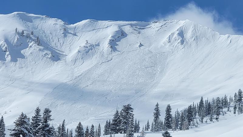
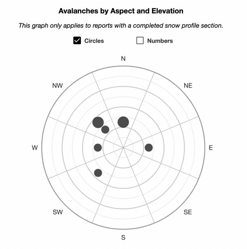
Today, the avalanche danger remains CONSIDERABLE at the upper and mid-elevation slopes facing west through north and southeast. Deadly slab avalanches may fail in a persistent weak layer and be up to 6' deep. On all other slopes, the avalanche danger is MODERATE.
With the sun, the solar aspects may experience pinwheels, roller balls, and small sluffs as the cold snow heats up.
Yesterday should have served as a significant warning sign - we have a textbook setup for an avalanche accident. With clear skies, backcountry riders may be lured by the appealing riding conditions, but avalanche conditions remain dangerous. Most avalanche accidents and fatalities occur after peak instability. Avalanche terrain can be easily avoided today, as there is excellent riding on lower-angled slopes in all directions.
Low
Moderate
Considerable
High
Extreme
Learn how to read the forecast here
Special Announcements
There is a NEW beacon training park in Park City near the Park City Day School. We encourage you to check it out and practice your avalanche rescue skills.
Weather and Snow
This morning, skies are clear and temperatures range in the single digits F. Winds are primarily northwesterly and are light, with a few overnight gusts near 30 mph. Since yesterday morning, the mountains picked up an additional trace to 6" of snowfall.
Final storm totals since Feb 1st:
Upper Cottonwoods: 4.5' - 6' of snow / 5" - 6.6" of water equivalent (SWE)
Park City Ridgeline: 4' of snow / 4" of SWE
Skiing and riding conditions are excellent at all elevations across the range.
Today, high pressure will build over the area, bringing about dry and stable conditions accompanied by light winds. Skies will remain clear and temperatures will climb into the low to mid 20s F and northerly winds remaining light, gusting to 25 mph along the highest ridgetops.

There might be some unsettled weather later this week, but it's more likely to snow again by next Monday.
Recent Avalanches
Yesterday was active in the backcountry, with a few reports of sensitive slabs within the new snow. However, the primary red flags were massive avalanches failing into the buried Persistent Weak Layer, with two notable avalanches occurring at the following locations:
  • Main Gobblers - Millcreek Canyon - 9800' - Northwest Aspect - Hard slab failing on facets 5' deep - 400' wide - running approx 1000'
  • Cardiac Ridge - Cardiff Fork - 10,800' - East Aspect - Hard slab failing on facets 3.5-4' deep - approx 350' wide (See photo below).
This chart below from the UAC Data Explorer highlights the locations of both the smaller new snow avalanches, as well as the larger avalanches being triggered on PWL. Pay attention to the terrain and aspects being traveled today.

Be sure to make reading reported avalanches and observations part of your backcountry planning.
Ad
Avalanche Problem #1
Persistent Weak Layer
Type
Location
Likelihood
Size
Description
Yesterday's avalanches failing in the persistent weak layer (PWL) should serve as a stark reminder that this avalanche problem remains a serious concern, particularly in the most suspect areas—steep, shallow, and rocky terrain features where we know the persistent weak layer (PWL) exists, or areas that have previously avalanched on this persistent weak layer throughout the season.
Several feet of snow, containing over 6 inches of water, should eventually help heal our persistent weak layer (PWL) problem. However, for now, it has only complicates the situation. What was once a 1-2' slab in early February has now transformed into a 3-6' slab throughout the range, potentially even deeper in wind-drifted areas. These are deep and deadly hard-slab avalanches. The weak layer is just as strong as it was prior to the storm, but the slab over the top is significantly thicker. The bottom line is that there's more weight, resulting in larger avalanches. It's imperative to give this weak layer time.
While the new snow instabilities should be settling, there may still be some sensitive soft slabs across all aspects and elevations in the range. Any avalanche initially triggered in the new snow could potentially step down deeper in areas where the persistent weak layer (PWL) is known to exist.

Be mindful not to let the appealing riding conditions overshadow the avalanche conditions. Opt for lower-angle terrain for safer riding. The clear skies are creating conditions ripe for potential avalanche accidents. Our primary objective is ensuring everyone returns home safely at the end of the day.
General Announcements
This information does not apply to developed ski areas or highways where avalanche control is normally done. This forecast is from the U.S.D.A. Forest Service, which is solely responsible for its content. This forecast describes general avalanche conditions and local variations always occur.