Forecast for the Salt Lake Area Mountains

Dave Kelly
Issued by Dave Kelly for
Thursday, December 8, 2022
A CONSIDERABLE avalanche danger exists on steep northwest to east facing slopes at the mid and upper elevations. Human triggered avalanches 1-3' deep and up to 300' wide are likely...and may be triggered at a distance.
A MODERATE avalanche danger exists on all southwest-south-southeast facing slopes and in the low elevation bands.

Loose new snow avalanches can be expected in steep terrain with new snow today.

Great skiing can be had on low angle terrain not attached to steeper slopes.
Low
Moderate
Considerable
High
Extreme
Learn how to read the forecast here
Special Announcements
Join the Utah Avalanche Center and the Division of Outdoor Recreation to celebrate the Fourth Annual Avalanche Awareness week, from December 4 - December 11. Click here to view the full list of events for the week. The next event is a - Fireside Chat with Drew Hardesty at LonePine.
Weather and Snow
Under overcast skies light snow is currently tapering off. Most mountain locations picked up 3-4" of low-density new snow. Temperatures are in the mid-teens F at the trailheads and low-teens F at the higher weather stations. Winds are blowing westerly in the mid teens at the 9000' ridgelines and into the mid 20's MPH gusting to the 30's MPH at the 11,000' ridgelines.
For today, partly cloudy skies with lingering clouds and winds peaking early this morning before decreasing throughout the day. 9000' ridgeline winds will be westerly 15 gusting to 25 MPH and the 11,000' ridgeline winds will be 20 gusting to 30 MPH. Temperatures will be 21-25 F.

There are places where you will find ripping good skiing on lower angle slopes that don't have a thermal crust from the other day's solar warming.
Mark Staples put together a comprehensive Weather and Snow Summary HERE>
Recent Avalanches
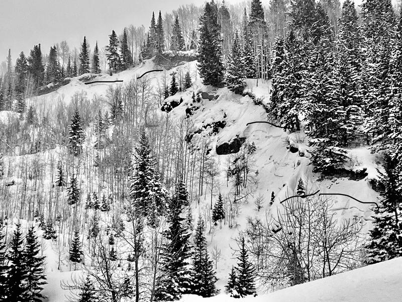
Reports of avalanches from Daly Canyon at 7500' on west-northwest aspects in Park City. Most likely triggered on the 6th of December.
The weak layer in these avalanches was most likely the old snow interface made up of buried surface hoar or buried near surface facets.
Daly Canyon (Hennigh)
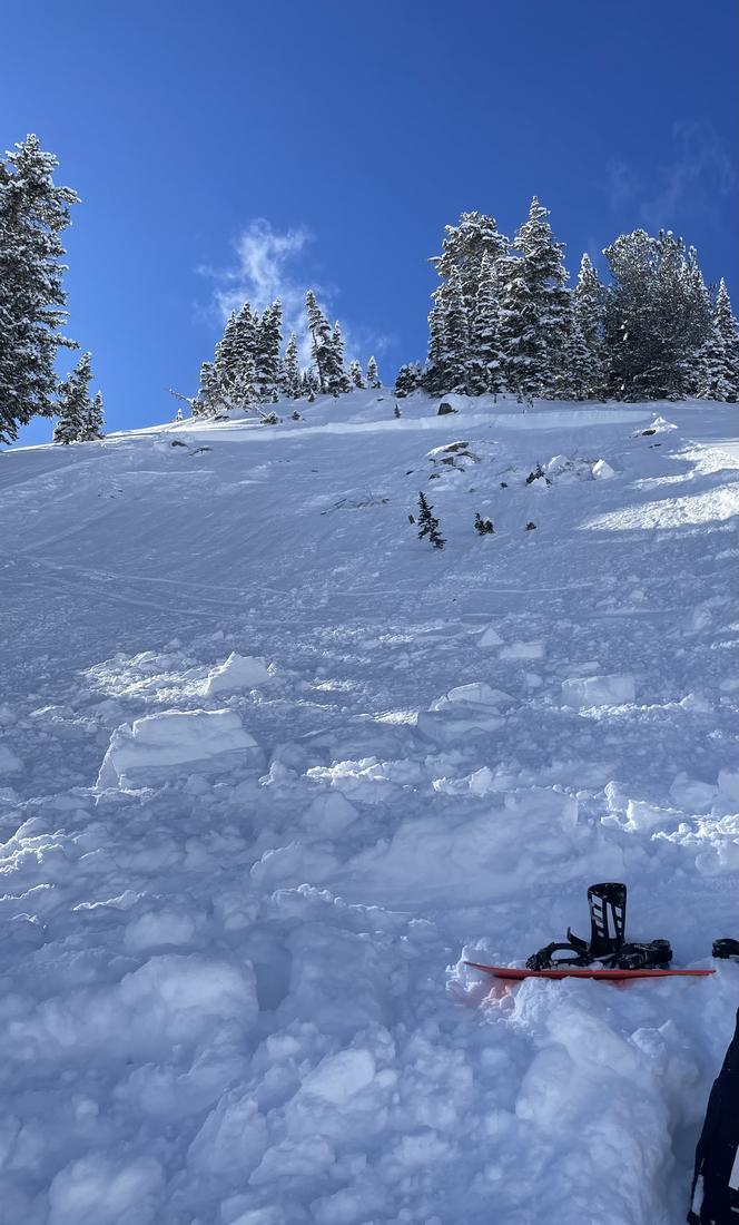
There were a number of avalanches reported on Tuesday December 6th all failing on the November persistent weak layer of sugary facets.
  • Dutch Draw on the Park City Ridgeline 9800' east Facing 1-2' deep and 200' wide
  • Red Rock Chutes on the Park City Ridgeline 9600' northeast facing estimated 18" deep 50' wide
  • Lackawaxen in upper Big Cottonwood Canyon 10,600' 1-2' 60' wide
  • Rocky Point above Lake Catherine 10,400' northeast facing 2' deep 50' wide
Photo of Lackawaxen Avalanche ( Chris)
Check out the list of avalanche activity HERE.
(Uncertain of locations? Check out the Wasatch Backcountry Skiing map...or app on your phone)
Ad
Avalanche Problem #1
Persistent Weak Layer
Type
Location
Likelihood
Size
Description
The mid-November drought created a very weak layer of facets and patches of buried surface hoar on all aspects and elevations throughout the Wasatch Range. Avalanches have been triggered at this weak interface as well as collapsing and whoomphing. These signs are clear red flags that avalanches could occur today.
Northwest through east facing aspects harbor a layer of weak faceted snow and have also seen the most wind loading and this is why the danger remains considerable on these aspects. On southwest-south-southeast aspects the danger remains moderate because there is less snow on top of the weak faceted layer and there is a lower likelihood of triggering an avalanche on these aspects. Mark Staples explains more about southerly slopes in the video below.
Additional Information
MOST ACCIDENTS AND FATALITIES OCCUR DURING A CONSIDERABLE AVALANCHE DANGER THAT INVOLVES A PERSISTENT WEAK LAYER.
A word to the wise: Don't get fooled.
As avalanches become more stubborn and cracking and cracking become less commonplace, there can be a tendency to believe that conditions are improving faster than they are.
The GOOD NEWS is that riding conditions are 5 STAR on shady low angle slopes. Choose low angle terrain with nothing steep above you.
General Announcements

This information does not apply to developed ski areas or highways where avalanche control is normally done. This forecast is from the U.S.D.A. Forest Service, which is solely responsible for its content. This forecast describes general avalanche conditions and local variations always occur.