UDOT PLANNED AVALANCHE CLOSURES!!

Forecast for the Salt Lake Area Mountains

Nikki Champion
Issued by Nikki Champion on
Monday morning, December 30, 2024
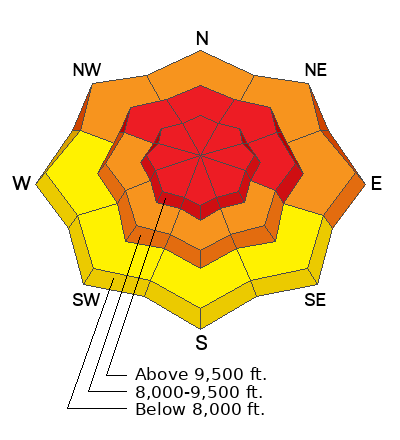
The avalanche danger is HIGH on all upper-elevation aspects and mid-elevation slopes facing northwest through north and east, where new snowfall and strong winds have created very dangerous conditions.
Any avalanche triggered in the wind-drifted or new snow could step down 1-6 feet into weak faceted layers, resulting in large, dangerous, and potentially deadly avalanches. Natural and human-triggered avalanches are likely.

What to do: Avoid avalanche terrain today. Stick to slopes less than 30 degrees, and stay well away from slopes connected to or below anything steeper than 30 degrees.
Low
Moderate
Considerable
High
Extreme
Learn how to read the forecast here
Avalanche Warning
What: The avalanche danger for the warning area is HIGH today
Where: For the mountains of Northern Utah, and Southeastern Idaho, including the Uintas...Wasatch Range...Bear River Range...Wellsville Mountains
Impacts: Recent heavy snow combined with strong wind is creating widespread areas of unstable snow. Both human-triggered and natural avalanches are likely.
What to do: Avoid all avalanche terrain. Stay off of and out from under slopes steeper than 30°. Carry and know how to use avalanche rescue equipment. Find safer riding conditions on slopes less than 30° with no overhead hazard
Warning Times: Monday December 30, 2024 - 6:00am to Tuesday, December 31, 2024 - 6:00am
Weather and Snow
This morning, skies are overcast, and snow continues to fall across the range. Temperatures are in the upper teens to low 20s °F. Winds have decreased overnight, now blowing west-northwest at 10-25 mph, with gusts up to 40 mph. Near the highest ridges, gusts are still reaching 60 mph, down from overnight peaks of 100 mph. Weather stations report 3-9" of new snow overnight, bringing storm totals to 17-38" and up to 5.53" of water.
Today, The Pacific Northwest storm system will exit the area this morning. Snow should taper off by afternoon, with an additional 2-4" expected in the mountains. Winds will continue to ease throughout the day, averaging 10-15 mph at mid-elevations and 15-25 mph at the highest peaks, with gusts up to 40 mph. Temperatures will rise into the mid-20s °F.
Looking Ahead: A gradual warming trend will take hold this week. A weak storm will graze northern Utah Wednesday into early Thursday, bringing 1-3" of snow to the northern mountains. Another, potentially stronger system is expected this weekend, with 6-12" of snow possible for the northern and central mountains, depending on its track and intensity.
Recent Avalanches
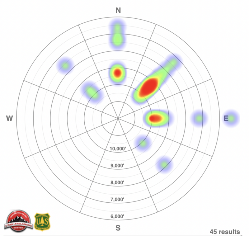
Between December 28th and 29th, 46 backcountry avalanches were reported to the Utah Avalanche Center from the Salt Lake, Provo, and Ogden area mountains. Of these, 30 occurred in the Salt Lake area alone. Notably, 29 avalanches failed on facets, while one failed on a ground interface, likely involving old faceted snow. Many were triggered remotely or from a distance, and failed multiple feet deep and over a thousand feet wide.
Ski resorts across the region reported effective control work by afternoon. Widespread skier-triggered activity was observed above the rain/rime layer, with limited activity penetrating into the rain layer. Resorts in Little Cottonwood Canyon reported multiple 8-foot crowns in high alpine terrain, including areas untouched by control work.
Below is the avalanche heat map highlighting recent activity across the Salt Lake, Provo, and Ogden area mountains. For detailed observations and reports, check out all avalanche observations HERE.
Ad
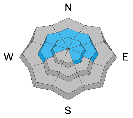
Avalanche Problem #1
Persistent Weak Layer
Type
Location
Likelihood
Size
Description
A widespread persistent weak layer (PWL) of faceted snow is now buried under feet of recent storm snow, creating dangerous avalanche conditions.
Strong winds and heavy snowfall have overloaded this weak layer, resulting in nearly 50 avalanches over the past three days, many of which were triggered naturally or remotely. With ongoing elevated winds and more overnight snowfall, avalanches on this PWL will only grow larger.
Avoid being on, underneath, or adjacent to slopes steeper than 30° in steepness. These slides can be triggered remotely, from a distance, or even from below.
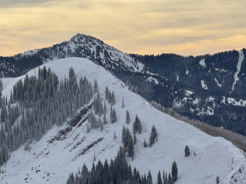
A large natural avalanche on the West Desolation Ridgeline failed within a persistent weak layer of facets, approximately 5 feet deep and 1,000 feet wide. This is the type of avalanche we could see in the backcountry today. Photo: N. Burr

If water percolates down to the persistent weak layer at lower and mid elevations, it could create a significant problem. While this is a more localized issue, as many of these areas had little to no snow before the recent storm, they could still catch riders off guard—especially those attempting to avoid the higher avalanche danger at upper elevations.
Avalanche Problem #2
Wind Drifted Snow
Type
Location
Likelihood
Size
Description
Northwesterly winds were cranking overnight, with gusts over 100 mph. With snow available for transport, we'll find both soft and hard slabs of wind-drifted snow on all upper and mid-elevation slopes. With winds this strong, we could even see drifts in lower-elevation terrain features that allow snow to accumulate. These high winds can load any aspect as they swirl and cross-load snow across the mountains.
These smooth, rounded pillows of wind-drifted snow may look inviting, but they’re sitting on top of very weak surface layers. While these drifts alone could catch and carry a rider, combined with buried persistent weak layers, they could trigger much larger avalanches, breaking 1-8 feet deep and nearly 2000 feet wide.
The best riding will be in sheltered, lower-angle terrain out of the wind.
Avalanche Problem #3
New Snow
Type
Location
Likelihood
Size
Description
Out of the wind zone, you may find sensitive new snow today. Expect shallow new snow avalanches in the backcountry, particularly at upper elevations that avoided rain in the last 48 hours, with fast-running sluffs and shallow soft slabs likely. At lower elevations, the new snow may sit atop the firm rain crust, resulting in poor bonding and increased sensitivity, though these slides will generally be shallower than those at upper and mid-elevations.
Watch for signs of instability, such as cracking and sluffing at all elevations, as even small slides can pose serious risks in steep terrain, near cliffs, or in terrain traps.
Additional Information
It's not all doom and gloom. This weak layer will settle out eventually and, in the meantime, you can travel on slopes less than 30° in steepness, check out some of our free online learning, or work on your rescue skills in lower angle meadows.
General Announcements
This information does not apply to developed ski areas or highways where avalanche control is normally done. This forecast is from the U.S.D.A. Forest Service, which is solely responsible for its content. This forecast describes general avalanche conditions and local variations always occur.