Forecast for the Salt Lake Area Mountains

Dave Kelly
Issued by Dave Kelly on
Sunday morning, December 29, 2024
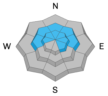
The avalanche danger is HIGH in upper-elevation terrain, and on mid-elevation northerly facing terrain. Avalanches may break 1'-6' deep and over 1800' wide. Natural and human-triggered avalanches are likely.
There is a CONSIDERABLE avalanche danger on mid elevation west and southerly-facing slopes, and there is a moderate danger on low elevation slopes where we may see some wet loose avalanches.

With this most recent storm, high winds, and rapid warming coming in on top of a very weak early season snowpack avoid traveling on or under any slope greater than 30°.
Low
Moderate
Considerable
High
Extreme
Learn how to read the forecast here
Avalanche Warning
What: The avalanche danger for the warning area is HIGH today
Where: For the mountains of Northern Utah, and Southeastern Idaho, including the Uintas...Wasatch Range...Bear River Range...Wellsville Mountains
Impacts: Recent heavy snow combined with strong wind is creating widespread areas of unstable snow. Both human-triggered and natural avalanches are likely
What to do: Avoid all avalanche terrain. Stay off of and out from under slopes steeper than 30°. Carry and know how to use avalanche rescue equipment. Find safer riding conditions on slopes less than 30° with no overhead hazard
Warning Times: Sunday, December 29, 2024 - 6:00am to Monday, December 30, 2024 - 6:00am
Weather and Snow
Currently, under partly cloudy skies trailhead temperatures are in the low 30's °F and the highest ridgelines are in the mid 20's °F. Winds at the lower ridgelines are blowing from the southwest in the mid 20's gusting to the 40's and the winds at the highest ridgelines are blowing from the southwest in the 40's gusting to the 70's MPH. Gusts at the highest ridgelines were pushing into the 80's MPH. In the last 24 hours weather stations have reported 4"-10" of new snow which brings our storm totals to 15"-34" of snow and 1.5"-4.5" of water. There was a riming event last night at the higher elevations and you'll find a thick breakable crust on the snow surface below 8,500'.
If you've ever wanted to experience a coastal style storm, we're in the midst of one right now. It makes for great base building but isn't always the most pleasant or safest while it's happening. With these temperatures, I wouldn't rule out wet loose avalanche activity at lower elevations.
For today, building clouds with light snowfall of 1"-2" possible. Temperatures will be 36-40 °F and the freezing level will hover around 8,000'. There is a chance we could see rain at lower elevations later this afternoon. Winds will blow primarily from a westerly direction 25 gusting to 40 MPH at the lower ridgelines and 50 gusting to 70 MPH at the higher and more exposed ridgelines. As the jet stream tracks directly over Northern Utah, we could see wind gusts pushing 90 MPH this afternoon on the highest peaks.
Recent Avalanches
Yesterday, there were 12 backcountry avalanches reported to the Utah Avalanche Center from the Salt Lake Region. Ski area operations reported dozens more that were intentionally triggered on all aspects and elevations within their boundaries. Some running as far as 1400' vertical feet with crown faces up to 8' deep. I have highlighted some of the backcountry avalanches below and you can check out all avalanche observations HERE.
Ad
Avalanche Problem #1
Persistent Weak Layer
Type
Location
Likelihood
Size
Description
Buried under the newest storm snow is a weak layer of faceted snow. This weak snow has now been and will continue to be overloaded creating dangerous avalanche conditions. Avoid being on, underneath, or adjacent to slopes steeper than 30° in steepness. Avalanches involving persistent weak layers (PWL's) can be triggered remotely (from a distance) as we saw with the Twin Lakes Pass avalanche which was triggered by an avalanche class from the ridgeline.
Photo of a remote triggered avalanche failing on buried facets above Lake Desolation. This avalanche was remotely triggered on a northeast aspect at 9,600' in elevation 3' deep x 300' wide x 600' vertical ( Photo: N Burr)
If water were to percolate down to persistent weak layer at lower and mid elevations then it will create a problem. This is a localized problem as many of these locations had little to no snow before this most recent storm. They may catch a rider trying to avoid higher avalanche danger at upper elevations.
Avalanche Problem #2
Wind Drifted Snow
Type
Location
Likelihood
Size
Description
Once the winds start to blow at these speeds all bets are off when it comes to the location of wind drifted snow. Strong westerly winds can kick around in the lower drainages and blow due east. Keep any eye out for wind loaded areas of new snow and stay off of and out from under slopes greater than 30° in steepness. These wind drifted snow avalanches could be enough to catch and carry a rider, however combined with the buried persistent weak layers this could make for much larger avalanches breaking 1'-6' deep and up to 1800' wide. The very nature of strong winds is that they will load slopes on all aspects regardless of wind direction.
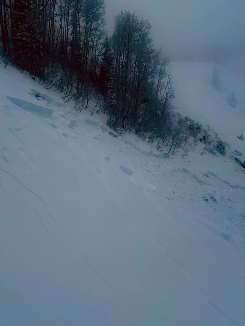
This natural avalanche probably failed during periods if increased snowfall coupled with very strong winds. This was on a northeast aspect at 9,400' in Willow Fork. This avalanche was 4' deep x 250' wide x 350' vertical (Photo: B).
Additional Information
It's not all doom and gloom. This weak layer will settle out eventually and, in the meantime, you can travel on slopes less than 30° in steepness, check out some of our free online learning, or work on your rescue skills in lower angle meadows.
General Announcements
This information does not apply to developed ski areas or highways where avalanche control is normally done. This forecast is from the U.S.D.A. Forest Service, which is solely responsible for its content. This forecast describes general avalanche conditions and local variations always occur.