Check Out Our Holiday Auction!

Forecast for the Salt Lake Area Mountains

Brooke Maushund
Issued by Brooke Maushund on
Wednesday morning, December 3, 2025

Welcome to Winter 2025-2026. Today is our second day of issuing daily danger ratings. Be sure to check back in tomorrow.

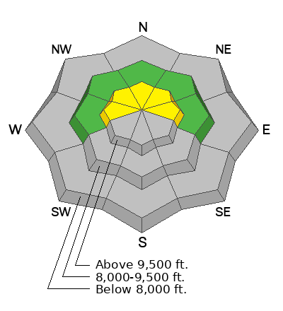
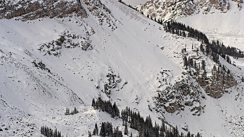
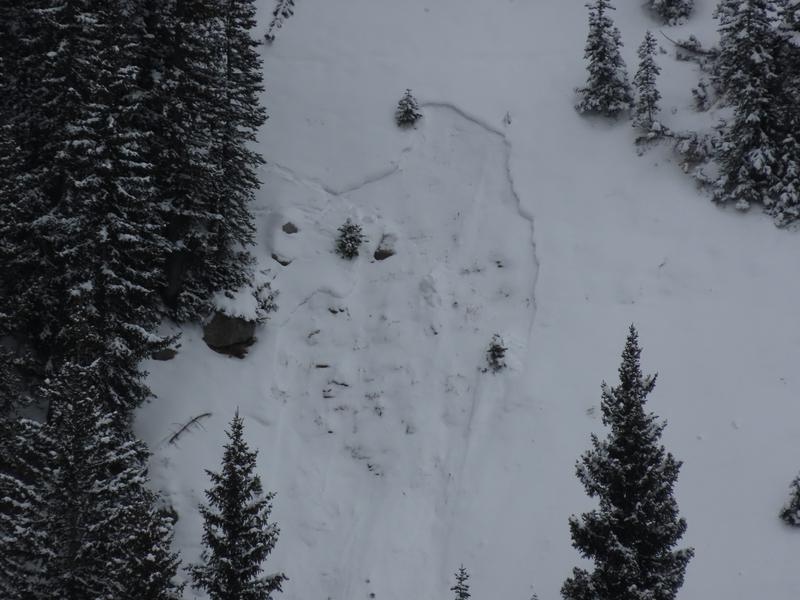
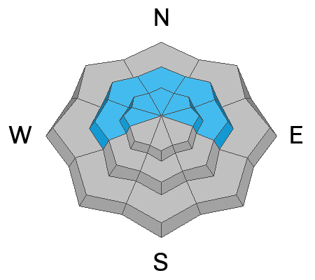
While most terrain is either at LOW or NO danger (due to the lack of snow on the ground), areas of MODERATE avalanche danger exist on shady (west-north-east facing) slopes above about 9000’. Here, you can trigger shallow soft slabs of snow 10-16” deep and up to 100’ wide or long-running, gouging sluffs that can rag-doll you or bury you, particularly in terrain traps. Note that, particularly in wind-drifted terrain, it may be possible to trigger these soft slabs at a distance. The snowpack is thin with a weak base, and low tide hazards like shallowly-covered rocks, logs, and holes continue to be a concern.

North-facing slopes hold the most snow and will look the best to ride, but they’re also the most suspect. Southerly-facing slopes were mostly bare before this storm. Coverage is low to non-existent on aspects shown in grey on the danger rose, so keep that in mind and follow safe travel practices.

Low
Moderate
Considerable
High
Extreme
Learn how to read the forecast here
Special Announcements

Avalanche Awareness Week started yesterday! Events are happening daily across the state to prepare you for winter and get you thinking about avalanche safety.

Find out about all our events HERE. And don't forget the Utah Snow and Avalanche Workshop is this Saturday, December 6, with in-person and virtual options!

Just a few of the upcoming events this week:

Weather and Snow

This morning, mountain temperatures range from the low teens to low 20s F after up to 2" of snow fell in the Cottonwoods yesterday. Winds shifted from the NW to the E/NE overnight, and have been blowing less than 15mph.

Today, there's a possibility of some light snowfall in the morning before the NW flow leaves us dry. As an outlier, there’s some chance ridgetop winds will increase out of the East/Northeast and start to drift snow along the higher ridgelines. Note that—if this occurs—this will result in unusual loading patterns where north to westerly facing slopes may be drifted with unstable snow. As of 6:30am, easterly winds have picked up more than 10mph since I started writing. Temps will stay between the high teens to mid 20s F.

By early Friday, a warmer and wetter pattern starts moving in as a strong, upper-level jet associated with an atmospheric river makes its way towards Northern Utah. There is still uncertainty about how far south the bulk of this moisture can reach, as models continue to disagree on how much snow we'll be getting in the Wasatch. BUT there's a chance of some heavy snowfall late Friday through the weekend—cross your fingers and check back tomorrow.

Recent Avalanches

Human- and naturally-triggered avalanche activity continued yesterday. In upper LCC, the Alta avalanche office noted that a natural D2 (large enough to bury a person) released with increased winds in the Castle (steep northeast-facing slope at 10,500’. ) It looked to be about 10-16" deep and 40' wide. Photo below. Alta is not yet open to the public and they haven't started full avalanche operations yet. (And as a reminder, are not open for uphill travel.)

Also, along the Park City ridge, avalanche control teams intentionally triggered a shallow soft slab 8” deep, failing on the old weak faceted snow on a northeast-facing slope at 9700’.

Hathcock triggered a 12" wind-drifted soft slab pocket on a NE aspect of Davenport Hill in LCC. The slide gouged down to the weak snow at the ground, with debris deep enough to bury a person.

Check out Hathcock's video of the slide HERE.

Just across Michigan City, we spotted a day old slab release to the ground off the north facing Patsy Ridge above Michigan City near 9800'. Another animal perhaps?

Slab avalanche off Patsy Marley - N Aspect - 9800'

Be sure to check out all observations HERE.

Avalanche Problem #1
Persistent Weak Layer
Type
Location
Likelihood
Size
Description

October and November's intermittent storms left old snow sitting out to weaken and facet on upper and mid-elevation E-N-W slopes. Sunday through Monday brought 2-5 inches of fresh snow to the Central Wasatch, now burying this weak suspect snow.

Currently, this issue is not widespread. The main concern today is in areas that held old snow and received some wind. In addition to the large natural at Alta, riders yesterday were able to find 10-16" deep soft slab pockets in high, wind-loaded terrain that, when intentionally triggered, gouged down to the ground. The debris was deep enough to bury a person.

The problem is that our thin snowpack makes the most suspect slopes look the best to ride, as they have the best coverage. The other side of it is that southerly-facing slopes, which don’t hold the weak faceted snow, were mostly bare before this storm and aren’t really worth riding right now either.

As additional snow or wind adds load to this weak faceted snowpack, avalanche danger will increase, so continue to pay attention to which slopes held snow prior to the incoming storms.

Below, I talk about the snow setup near East Bowl Pass in LCC yesterday, 12/2

General Announcements

This information does not apply to developed ski areas or highways where avalanche control is normally done. This forecast is from the U.S.D.A. Forest Service, which is solely responsible for its content. This forecast describes general avalanche conditions and local variations always occur.