Forecast for the Salt Lake Area Mountains

Nikki Champion
Issued by Nikki Champion for
Sunday, December 27, 2020
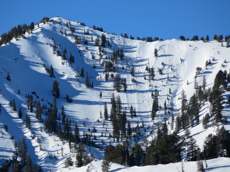
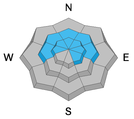
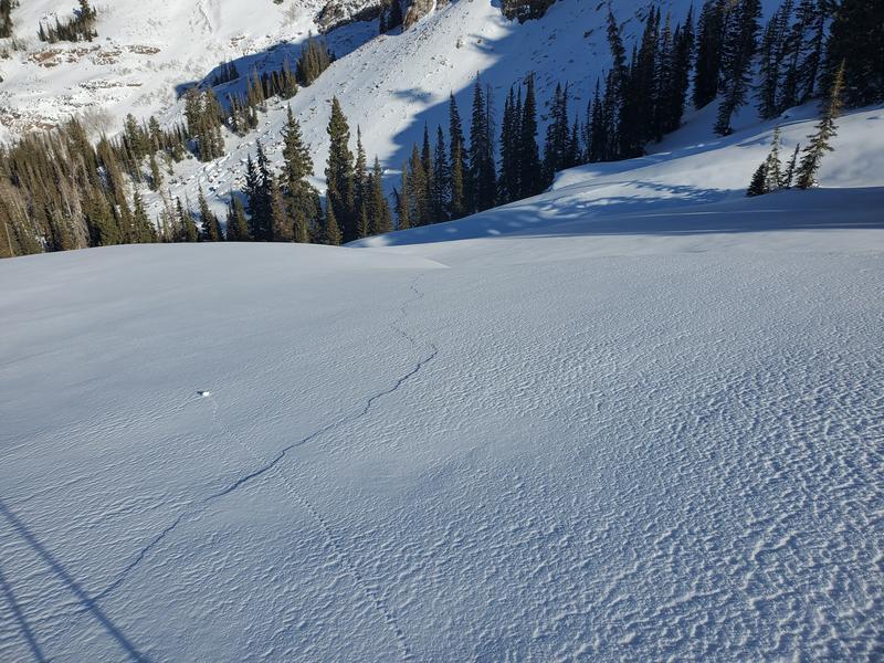
Human triggered avalanches remain likely at the mid and upper elevations on aspects facing, west, north and east where the weak faceted snow combined with fresh wind drifts are the main avalanche problems. In these places the avalanche danger is CONSIDERABLE. Stay off of and out from underneath slopes 30° degrees and steeper at the mid and upper elevations. If you trigger an avalanche, it is likely to break down 1-3' and up to several hundred feet wide. These avalanches may be triggered remotely and from lower-angled terrain

On upper and mid-elevation southerly aspects there is a MODERATE danger.

All low elevation aspects have a LOW danger.
Low
Moderate
Considerable
High
Extreme
Learn how to read the forecast here
Special Announcements
Thanks to the generous support of our local resorts, Ski Utah, and Backcountry, discount lift tickets are now available.
Support the UAC while you ski at the resorts this season. Tickets are available here.
Weather and Snow
This Morning: Skies are overcast with light snowfall, temperatures at the lower-elevation trailheads are in the teens to low 20's F and are single digits along upper elevation ridges and peaks. Winds are out of the west/northwest and in the teens at mid-elevations, gusting into the upper 20s mph. At upper elevations, the wind speeds are averaging near 30 mph with gusts near 50 mph. Overnight the westerly and northwesterly winds hit gusts near 70 mph at uppermost elevations. Snow totals since yesterday are currently at 1-3".
For Today: This light snow will taper off this morning, as this fast-moving storm exits the area. Temperatures will rise to the upper teens and mid 20s F. Northwesterly winds will begin to decrease throughout the day, with gusts up to 25 mph at mid-elevations. At upper elevations, averages will be 15-25 mph with gusts up to 35 mph.
Next Storm: The next storm should move in tomorrow. Expect periods of moderate snowfall tomorrow through tomorrow night. Between the 28th and 29th we could get 7-14" of snow, and up to 1" of water.
Recent Avalanches
Week in Review: It has been active this past week, with snowfall, wind and over 30 natural and human-triggered avalanches reported. Catch up by reading our Week in Review - where we highlight significant snow and weather events from the past week.

No new avalanches were reported in the backcountry yesterday, previous reports of remotely and sympathetically-triggered avalanches continue to roll in:
Thursday 12/24 - West Monitor on Park City Ridgeline. Control work from Park City resorts triggered slides up to 500' wide and 1-2' deep. In Days Fork a remotely-triggered avalanche at the top of Banana Days which then sympathetically pulled out two avalanches in adjacent Main Days. [Photos B. Nalli]
Friday 12/25 - Red Rocks Chute on Park City Ridgeline. Remotely-triggered soft slab on the persistent weak layer of facets. This avalanche was 60' wide and 14" deep.
This heat map shows the distribution of avalanches in the Salt Lake mountains since Thursday, December 17. They have been on aspects facing northwest through east - focused on northeast and east - above 9000'.
Ad
Avalanche Problem #1
Persistent Weak Layer
Type
Location
Likelihood
Size
Description
A persistent weak layer (PWL) of faceted snow and depth hoar exists in the bottom foot of the snowpack on mid and upper-elevation slopes primarily facing west, north and east. Snowfall and wind-drifted snow this past week have overloaded these weak layers, with several remotely-triggered avalanches. Yesterday's increased winds and snowfall will only continue to add load and stress to this snowpack. Thursday's remote slide in Banana Days and then sympathetically-released slide in adjacent Main Days illustrates how strong and connected the slab on top of the PWL has become.
These recent avalanches - as well as continued loud, booming collapses and cracking - are huge red flags, telling us that the weak snowpack structure still exists and needs more time.
Photo from Mill-B South demonstrating the widespread cracking, this is a big red flag. Pay attention to what the snowpack is trying to tell us. (Photo: W. Thomas)
Avoid slopes steeper than 30° on mid and upper elevation aspects facing west, through north, and east. Triggering an avalanche on these slopes is likely; they may be up to 2' deep and several hundred feet wide.
Avalanche Problem #2
Wind Drifted Snow
Type
Location
Likelihood
Size
Description
Over the last two days, the Westerly and Northwesterly winds have remained strong enough to drift snow, with gusts near 70 mph at the highest of ridgelines. The combination of any lingering soft snow from before yesterday and a few new inches of snow throughout the day will have allowed for new wind drifts to form at mid and upper elevations. With sustained high winds can deposit snow around terrain features on almost any aspect, called cross-loading. For this reason, I would expect to find sensitive slabs of wind drifted snow at all upper and mid-elevation slopes, especially along with terrain features such as ridgelines, sub ridges, and gullies.
Elevated winds this morning will continue to form both soft and hard slab avalanches in upper elevation wind drifted terrain. As the winds continue to blow, these slabs will become more firm and cohesive. Yesterday there were already reports of firm areas of wind drifted snow forming. This can allow you to travel out farther onto the slope before it breaks, and can fail larger and wider than expected. Triggering an avalanche that initially fails in the wind-drifted snow will likely break down more deeply into the weak faceted snow below.
Today continue to look for slopes with any signs of wind drifted snow, such as cracking, hollow noises, and pillow-shaped snow, and avoiding those slopes.
Additional Information
Looking into the future: Mark Staples describes a new weak layer forming on sunny slopes. Over the next few days, this new weak layer could be buried by a few inches of snow and preserve. If we get a lot of wind, or warm temperatures this layer could be melted or blown away. Time will tell if it survives and gets buried. If that happens, then it could cause avalanches in the future. For now, we’ll have to watch it. Either way, this faceting happens from a very delicate balance of radiation at the snow surface.
General Announcements
Please visit this website with information about Responsible Winter Recreation by the Utah Office of Outdoor Recreation.

This information does not apply to developed ski areas or highways where avalanche control is normally done. This forecast is from the U.S.D.A. Forest Service, which is solely responsible for its content. This forecast describes general avalanche conditions and local variations always occur.