UDOT PLANNED AVALANCHE CLOSURES!!

Forecast for the Salt Lake Area Mountains

Drew Hardesty
Issued by Drew Hardesty for
Monday, December 28, 2020
Areas of CONSIDERABLE danger exist on many west to north to easterly facing aspects in the mid and upper elevations. Human triggered avalanches 1-2' deep remain likely and these may be triggered on, adjacent to, or below steep slopes. A MODERATE danger exists for fresh drifts of wind blown snow in the mid and upper elevations.

Statistical Note - Most avalanche accidents occur when we have a Considerable danger with a persistent weak layer. Just saying.
Low
Moderate
Considerable
High
Extreme
Learn how to read the forecast here
Special Announcements
The Utah Avalanche Center podcast's second episode of season 4 is live - Managing Risk with Avalanches, Managing Risk with a Pandemic - A Conversation with state epidemiologist Dr. Angela Dunn
Stream here or tune in wherever you get your favorite podcasts

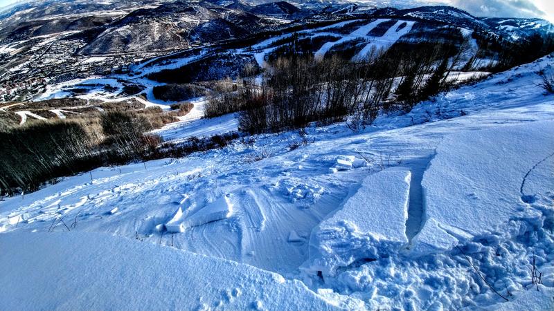
Deer Valley and Empire Canyon is closed to uphill travel as they begin operations in that terrain. Please avoid this area. Thanks.

Thanks to the generous support of our local resorts, Ski Utah, and Backcountry, discount lift tickets are now available.
Support the UAC while you ski at the resorts this season. Tickets are available here.
Weather and Snow
Skies are overcast. Mountain temperatures are in the teens.
Easterly winds picked up overnight as a storm system tracks across central/southern Utah. Hourly averages of these easterly winds are in the 20-25mph range, even on the less exposed ridgelines.
We may see some spillover snowfall from this storm that may add up to 2-5", with higher amounts favoring the upper reaches of the Cottonwoods and the Park City/Deer Valley side of the Park City ridgeline.
For today, snowfall may begin around lunchtime. Temps will be in the upper teens up high, the mid-20s down low. Winds from the east will continue to blow 20-25mph.
Saturday night's 2-3" of snow was more than window dressing - riding conditions vastly improved, particularly on lower angle protected slopes.
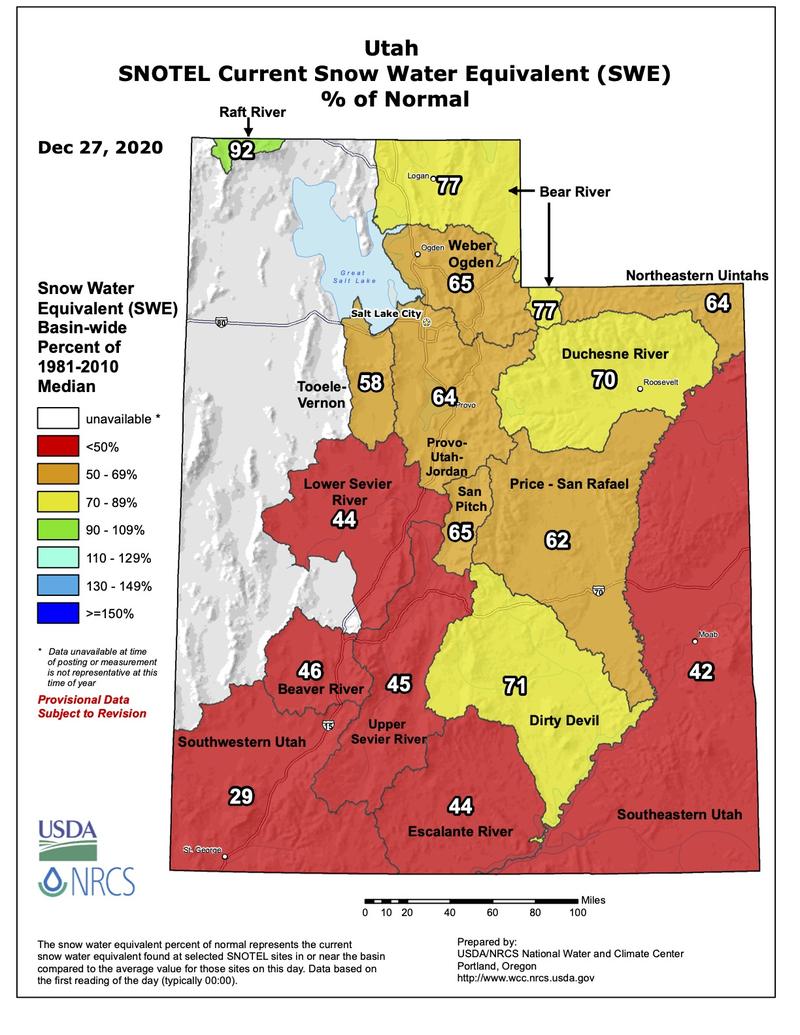
The weather outlook over the next week or so looks progressive. I'm not seeing any blockbuster storms, but we seem to have a storm roll through every few days that should produce some snow. Which is a good thing. Currently we sit at 65% of normal. (Ski trip to the City of Rocks, anyone?)
Recent Avalanches
Three more reports of human triggered avalanches from either the backcountry or uncompacted terrain. Collapsing and cracking remain general on west to north to east facing slopes.
  • Wilson Glade - on their third lap, a ski party triggered a soft slab avalanche 18" deep and 50' wide on a steep northeast facing rollover at 9300'.
  • Ski Team Ridge in closed terrain of PCMR - avalanche control teams remotely triggered two soft slab avalanches from the ridgeline on northeast facing slopes at 8600'. These were 12-16" deep and 50' and 100' wide. Note that 8600' is one of the lower elevation avalanches we've heard about...
It also looks like a human triggered avalanche from Saturday in the upper reaches of the White Pine drainage along the PC ridgeline. This slide is on northeast facing terrain at 9500', dimensions estimated 18" deep and 75' wide.

(photo of avalanche on Ski Team Ridge-PCMR snow safety - A. Hennigh)
Ad
Avalanche Problem #1
Persistent Weak Layer
Type
Location
Likelihood
Size
Description
Overall, the slab is settling and gaining strength and avalanches are becoming less sensitive and hair trigger. The weak layer, down 12-24", however, remains as weak as ever.
Regardless of whether the likelihood has somewhat diminished, the odds are still not good enough to dive into steep terrain. Some people have gotten away with it, but luck runs out eventually. I appreciated pro observer Mark White's sentiment from yesterday when he went out to check out the No Name area of the Park City ridgeline -
Walked out to No Name to have a look, it looked much more filled in than the last time I was there and knowing that it had a few feet of old faceted snow at the ground we walked away.
Avalanche Problem #2
Wind Drifted Snow
Type
Location
Likelihood
Size
Description
DON'T be surprised to find wind drifts in unusual areas today. East winds - particularly east winds that find their way into the mid-elevation bands - tend to load areas that catch people off guard. Try to have north to west to south facing slopes on your radar as potentially suspect. These drifts may be up to a foot deep and I wouldn't be surprised to hear of one triggered at a distance on south or west facing aspects.
REMEMBER that any slide triggered on west to north to easterly facing terrain may step down into older snow layers, resulting in a much more destructive avalanche.
Additional Information

The Selection of Desires
At the 2014 International Snow Science Workshop, long time Canadian (and Utah expat) heliski guide Roger Atkins presented a paper called Yin, Yang, and You. It was a watershed moment regarding communication of how we adjust our terrain selection in response to avalanche conditions. But hidden away in the essay was a paragraph or two called The Selection of Desires. A beautifully written piece about these things in life that bring us joy. The hidden gem is that if the only thing that brings us joy is the steep and the deep....we may not last very long. The excerpt is HERE.
General Announcements
Please visit this website with information about Responsible Winter Recreation by the Utah Office of Outdoor Recreation.

This information does not apply to developed ski areas or highways where avalanche control is normally done. This forecast is from the U.S.D.A. Forest Service, which is solely responsible for its content. This forecast describes general avalanche conditions and local variations always occur.