Sign Up for the Utah Snow and Avalanche Workshop (USAW) on December 7th!

Forecast for the Salt Lake Area Mountains

Greg Gagne
Issued by Greg Gagne on
Tuesday morning, December 24, 2019
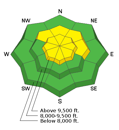
A serious and consequential MODERATE AVALANCHE DANGER exists for triggering an avalanche 2-5' deep on northwest, through north, and east aspects. The terrain that is most suspect includes steep/thin rocky slopes as well as repeater slopes that have already avalanched this season.
A MODERATE hazard also exists at the upper elevations, and mid-elevation aspects facing northwest through east, where strong and gusty winds from the south have created pockets of hard wind drifts.
All other terrain has a generally Low hazard.
Low
Moderate
Considerable
High
Extreme
Learn how to read the forecast here
Special Announcements
Stocking Stuffers: Thanks to the generous support of our Utah ski resorts and Ski Utah, we have discount lift tickets available. All proceeds from these go towards paying for avalanche forecasting and education! Get your tickets here.

Brighton Resort is closed to uphill traffic over the holiday period through January 1.
Weather and Snow
Currently: Mountain temperatures range through the 20's F and winds are from the south and gusty. At the mid-elevations winds have been averaging in the teens with gusts in the 20's and 30's mph. Along upper elevation ridgelines, winds are averaging in the 20's with gusts in the 30's and 40's mph. Snowfall totals since Monday afternoon are 2-4".
For today, you can expect periods of snow showers with another 1-3" expected during the day. Winds will be from the south and remain gusty, averaging in the teens with gusts in the 20's at mid elevations, and in the 20's with gusts in the 30's and 40's mph along upper elevation ridgelines.
A more-promising storm beginning overnight, with upwards of 6" of fresh snowfall by Wednesday morning.
Recent Avalanches
We received very few backcountry observations from Monday and no avalanche activity was reported.

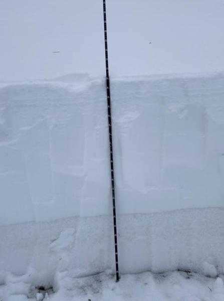
The recent avalanche I continue to pay attention to is a natural avalanche that occurred overnight Saturday in South Monitor bowl along the Park City ridgeline (observation). This slope has avalanched this season (known as a "repeater"), with weak faceted snow remaining in place on the bed surface. The slope had filled in again from wind-loading, and naturally avalanched, perhaps from a cornice fall, running on the old weak snow down near the ground. Nikki went to look at this slide on Monday, and describes the snowpack structure she found in her observation.
Ad
Avalanche Problem #1
Persistent Weak Layer
Type
Location
Likelihood
Size
Description
A dangerous structure of a strong slab of snow over a persistent weak layer of faceted snow down near the ground exists on mid and upper elevation aspects facing northwest, through north, and east. Although this weak layer has become mostly dormant over the past 5-7 days, several days of southerly winds have created dense wind slabs on the aspects where this weak layer can be found. Combined with additional wind and snow in the forecast, we may be adding enough stress to overload this persistent weak layer.
This problem is simply a structural issue (a strong slab over a persistent weak layer) and there will be no clues such as collapsing. Ski tracks on a slope provide meaningless stability data. The slopes that are most susceptible are (1) steep/thin rocky terrain, and (2) repeater slopes (i.e South Monitor) that have already avalanched this season and have a weaker snowpack.
The photo below (Dave Ream) illustrates the structure of stronger snow (lighter colored) over the weaker snow (darker colored) down near the ground.
Danger Trend: Steady to Increasing

Avalanche Problem #2
Wind Drifted Snow
Type
Location
Likelihood
Size
Description
Several days of sustained southerly winds have created pockets of dense wind slabs at the mid and upper elevations. Although this wind-deposited snow can mostly be found on leeward aspects facing northwest through east, strong and gusty winds can deposit snow on any aspect, especially at the upper elevations. Continued gusty winds today will have fresh snowfall to work with, creating new pockets of wind slabs.
As mentioned above under the discussion of the persistent weak layer, these wind drifts have also been loading the same aspects where the weak snow down near the ground exists.
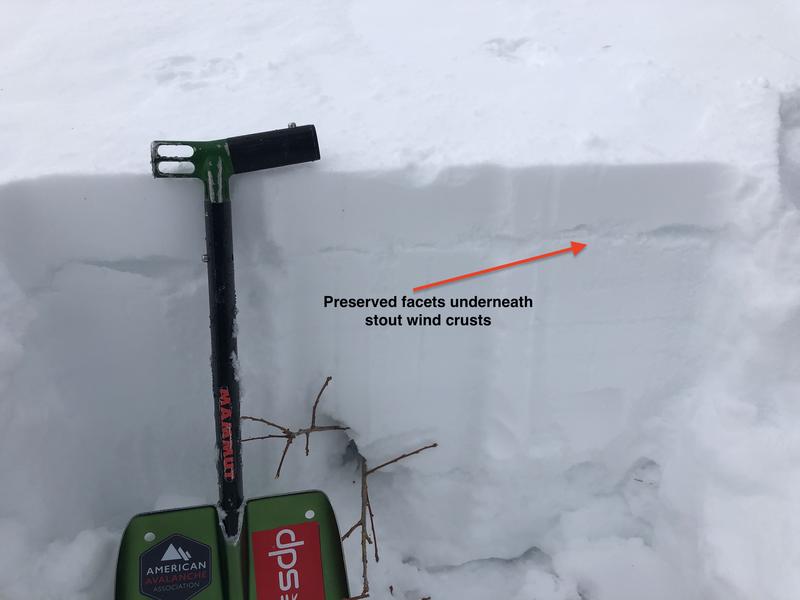
Observations from Monday indicated the wind slabs were unreactive to stability tests, however in my field work on Monday in the Ogden mountains (observation), I was finding some of these hard slabs were sitting on top of weaker faceted snow that formed on the snow surface late last week, creating a situation which may allow someone to get well onto a wind-loaded slope before it avalanches.
Danger Trend: Steady to Increasing
Additional Information
In Monday's forecast, Trent described using a propagation saw test (PST) to assess the propagation propensity of a weak layer with a slab on top. For those wishing to learn more about this test, I encourage you to look at Monday's archived forecast for more detail.
General Announcements
This information does not apply to developed ski areas or highways where avalanche control is normally done. This forecast is from the U.S.D.A. Forest Service, which is solely responsible for its content. This forecast describes general avalanche conditions and local variations always occur.