UDOT PLANNED AVALANCHE CLOSURES!!

Forecast for the Salt Lake Area Mountains

Dave Kelly
Issued by Dave Kelly for
Tuesday, November 8, 2022
With heavy snowfall and strong southerly winds natural avalanches are possible and human triggered avalanches are likely.
The avalanche danger will remain CONSIDERABLE throughout the day at elevations above 9500'. Look for and avoid wind drifted slopes, which will look smooth and rounded.
Early season conditions exist; traumatic injury is possible with any avalanche involvement.
Low
Moderate
Considerable
High
Extreme
Learn how to read the forecast here
Special Announcements
Thank you all for helping make our first in person USAW/PROSAW since 2019 a great success. We had online viewers from 4 countries and 38 states, as well as in person representatives from many of the local guide and ski area operations. Thank you to all the great presenters.
Many ski areas are now closed to uphill travel in order to prepare for winter operations. Resort uphill travel policies can be found HERE>.
Mill Creek Canyon Road will be closed November 8-10th for road work.
Weather and Snow
Another large, churning Pacific storm is on the doorstep and our partners at the SLC National Weather Service have issued a Winter Storm Warning for now through Thursday morning.
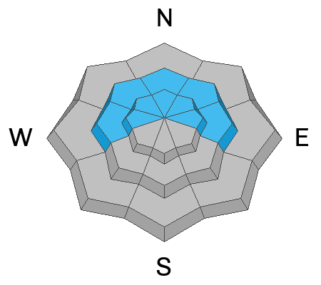
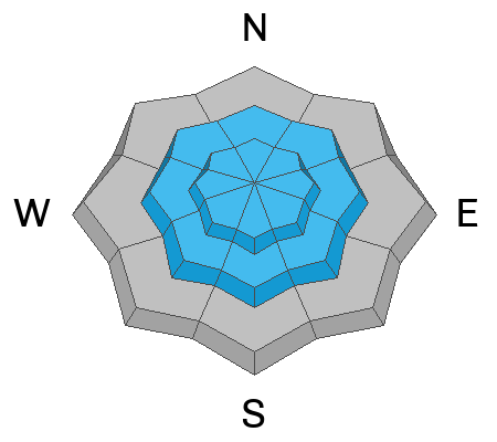
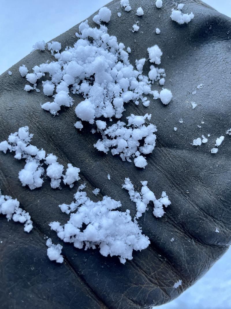
This morning we've had a couple inches of wind affected graupel. The winds at the 9,000' ridgelines are in the 20's gusting to the 30's (mph). The 11,000 ridgeline winds are in the 20's gusting to 60's (mph) from the south. Temperatures at lower elevations are in the high 30's and mid 20's F at highest stations. Yesterday there were reports of a rain/snow line to 9000' with rollerballs in Little Cottonwood Canyon. Watch for this rain crust at lower elevations as the season progresses.
2-3' of dense, supportable snow sits as our foundation with more on the way. The Ogden mountains have 12-24" on the ground; the Provo mountains 12-18".
For today, we'll have snow, heavy at times with up to a foot expected in the mountains. The possibility exists of 2" an hour snowfall rates. Southerly winds 25 gusting to 40 (mph) at the 9000' ridgelines and 40 gusting to 70 (mph) at the 11,000' ridgelines. For this evening another 9-16" of snow with winds increasing from the SSW. Storm totals are 18-32" of snow with 2.5-3.5" of water.
Check out Mark's Observation from before the storm started.
Recent Avalanches
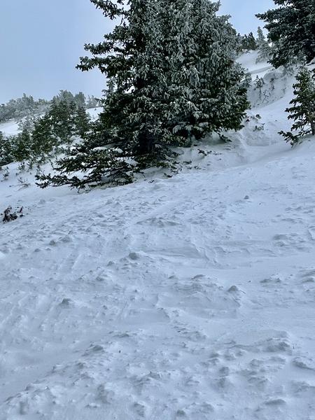
Yesterday observers reported a skier triggered soft slab avalanche on north facing Superior.
Nat Grainger had an excellent observation of a cornice triggered avalanche in the East Bowl of Silver Fork.
There were reports of roller balls up to 9000' at the top of Little Cottonwood Canyon and a rain/snow line hovering around 9000'.
East Bowl (Grainger)
Ad
Avalanche Problem #1
Wind Drifted Snow
Type
Location
Likelihood
Size
Description
With all the new snow and high winds sensitive soft slabs of wind drifted snow will be the number one concern on northerly aspects today. Natural and human triggered avalanches are likely with enough wind loading.
Look for sensitive cornice development and stay back from ridgelines where fresh cornices have developed.
Don't underestimate the extent of wind drifting and danger in the mid-elevations.
With this much continued wind, drifts may be found around terrain features even well off the ridgelines and cross-loaded into gullies and depressions.
Avalanche Problem #2
New Snow
Type
Location
Likelihood
Size
Description
The new snow will have bonded well to the old warm snow surface at lower elevations. For today keep an eye out for loose dry avalanches in the new snow during periods of increased snowfall. As snowfall continues there may be some areas that have soft slabs of new snow that may avalanche.
Places where graupel has accumulated below cliff bands could be areas to trigger avalanches.
Natural and human triggered avalanches are possible in the new snow.
Early AM Graupel (Kelly)
Additional Information
A Few Things to Remember:
  • Whether you're-hiking, hunting, skiing, boarding, snowshoeing or firing up the snowmachine, be prepared for avalanches
  • Any avalanche can produce serious trauma because of a thin snowpack
  • Hitting rocks and stumps is a real danger. Don't end your season early.
  • Treat ski resorts as backcountry terrain and check out the UAC site for resort uphill travel policies

It's never too early to start thinking about avalanches. A few things to consider:
1. Attend USAW and learn more about avalanches and decision making. (scroll down to the bottom of this page for more info and links)
2. Sign up for an avalanche class.
4. Take the all-new online avalanche courses the UAC built for Know Before You Go or take other online courses listed on the KBYG website (Develop skills -> Online Learning).
5. Get your avalanche rescue gear ready for winter. Put fresh batteries in your transceiver and update the firmware. Inspect your shovel and probe. Get your airbag backpack ready by doing a test deployment and update the firmware if it is an electric version.
Sign up for the 15th Annual Utah Snow and Avalanche Workshop (USAW) one night left, November 9th. Sign up and get more info for the second session HERE.
General Announcements

This information does not apply to developed ski areas or highways where avalanche control is normally done. This forecast is from the U.S.D.A. Forest Service, which is solely responsible for its content. This forecast describes general avalanche conditions and local variations always occur.