UDOT PLANNED AVALANCHE CLOSURES!!

Forecast for the Salt Lake Area Mountains

Dave Kelly
Issued by Dave Kelly on
Monday morning, November 27, 2023
The high elevation shady slopes that were holding October and November snow are the places where you could run into an avalanche problem. Steep slopes on the north half of the compass that look smooth and free of rocks will be the most suspect slopes. Dig down to assess if you have weak sugary crystals underneath a thicker slab of new or wind-loaded snow before committing to a slope. Any avalanche that you may trigger could mean a nasty ride through rocky terrain.

We are issuing intermittent snow and weather updates as our 2023-24 season snowpack builds, this update is from 0700AM Monday November 27, 2023.
Low
Moderate
Considerable
High
Extreme
Learn how to read the forecast here
Special Announcements
Check uphill travel policies at resorts before you head to their terrain.
Weather and Snow
Over the weekend cold and inverted temperatures were the name of the game. This week look for clearing skies and slightly warming temperatures as the valley inversion continues to build before a storm moves in later this week. You can get an updated weather forecasts twice a day from our partners at the National Weather Service. Another great resource is the weather station tab on the forecast page where you can find weather station data divided by region.
Across upper-elevation shady terrain that was harboring old October and early November snow, you will find weaker faceted grains buried in the bottom foot of the snowpack. These fragile crystals are now buried 1-3’ deep in many locations, and it is possible to trigger an avalanche on this layer.
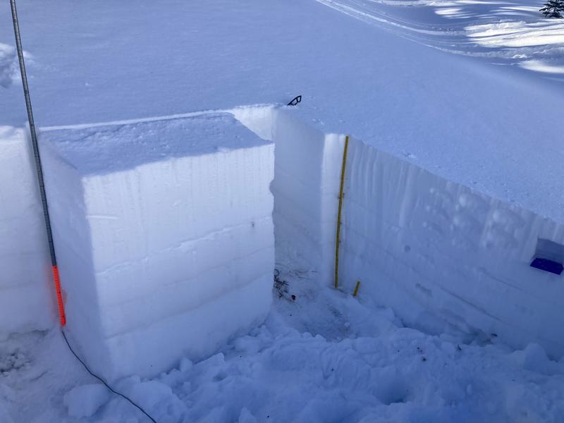
The best and safest option for riding and turning will be north-facing terrain that isn’t steep enough to avalanche (slopes less than 30° degrees in steepness) or areas that aren't harboring weak faceted snow on the ground. The only way to know is to dig down to the ground to see if you can identify these weak sugary grains with a slab of new or wind-loaded snow on top. A good example of this poor structure from S. Zimmerman-Wall showing weak faceted snow under the dirt layer is below.
Recent Avalanches
Backcountry travelers and ski area operations have reported avalanches triggered down into the old faceted snow near the ground within the last few days on high elevation shady slopes. Check out all avalanche and snowpack observations HERE.

Submit a snow and avalanche observation HERE.
Check out Trent's description of the current snowpack below.
Ad
General Announcements
Additional Information
  • It’s never too early to start thinking about avalanches. Here are a few things to consider doing:
  • Learn online. We have over 5 hours of free online learning at the Know Before You Go Website
  • Check out the upcoming in-person Know Before You Go events HERE
  • Sign up for an on-snow class
  • Check out the UAC's education progression HERE
  • Get your avalanche rescue gear ready for winter. Put fresh batteries in your transceiver and update the firmware. Inspect your shovel and probe. Get your airbag backpack ready by possibly doing a test deployment and updating the firmware if it is an electric version or getting your canister refilled if it's not electronic
This information does not apply to developed ski areas or highways where avalanche control is normally done. This forecast is from the U.S.D.A. Forest Service, which is solely responsible for its content. This forecast describes general avalanche conditions and local variations always occur.