Forecast for the Salt Lake Area Mountains

Drew Hardesty
Issued by Drew Hardesty for
Tuesday, January 23, 2024
The avalanche danger is CONSIDERABLE on many west to north to southeast facing slopes. Dangerous and tricky avalanche conditions exist. Cautious route-finding and conservative decision making is essential. Essential to what? - Essential to making it back to the trailhead at the end of the day. Be careful out there.
Low
Moderate
Considerable
High
Extreme
Learn how to read the forecast here
Special Announcements
Recent storms delivered unprecedented avy conditions and Extreme danger for the mountains of Northern Utah. Wondering how we got there and where we're going? Well then... you came to the right place!
Please join Craig Gordon this Thursday, January 25th from 6:00-7:30 for a State of the Snowpack presentation at Alpha Coffee's Big Cottonwood Canyon location- 7260 Racquet Club Dr, Cottonwood Heights, UT 84121
Weather and Snow
Skies are mostly cloudy. Mountain temps are in the 20s; winds are light from the southeast.
We do have a weak storm on tap for this evening, but at least it'll split around us. But all seriousness aside, we'll see a trace to 2" of new with a stronger storm slated for Thursday. Thursday's storm should offer an additional 5-10" - a nice refresh.
For today, we'll have mostly cloudy skies trending overcast with a few flakes early afternoon. Temps will be in the upper 20s to mid-30s. Winds will be light from the southeast, then shift around to blow 10-15mph from the northwest.
The Outlook: high pressure builds for the weekend with a warming trend on tap. And I do mean warm. The models suggest we could see mountain temps into the 40s and higher for early next week. We'll see.

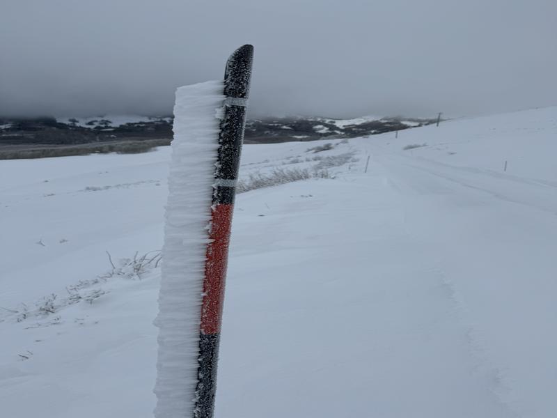
Yesterday's moist airmass bursting with super-cooled water droplets depositing rime in the mountains. Note rime growing into the wind. (pc: Porter)
Recent Avalanches
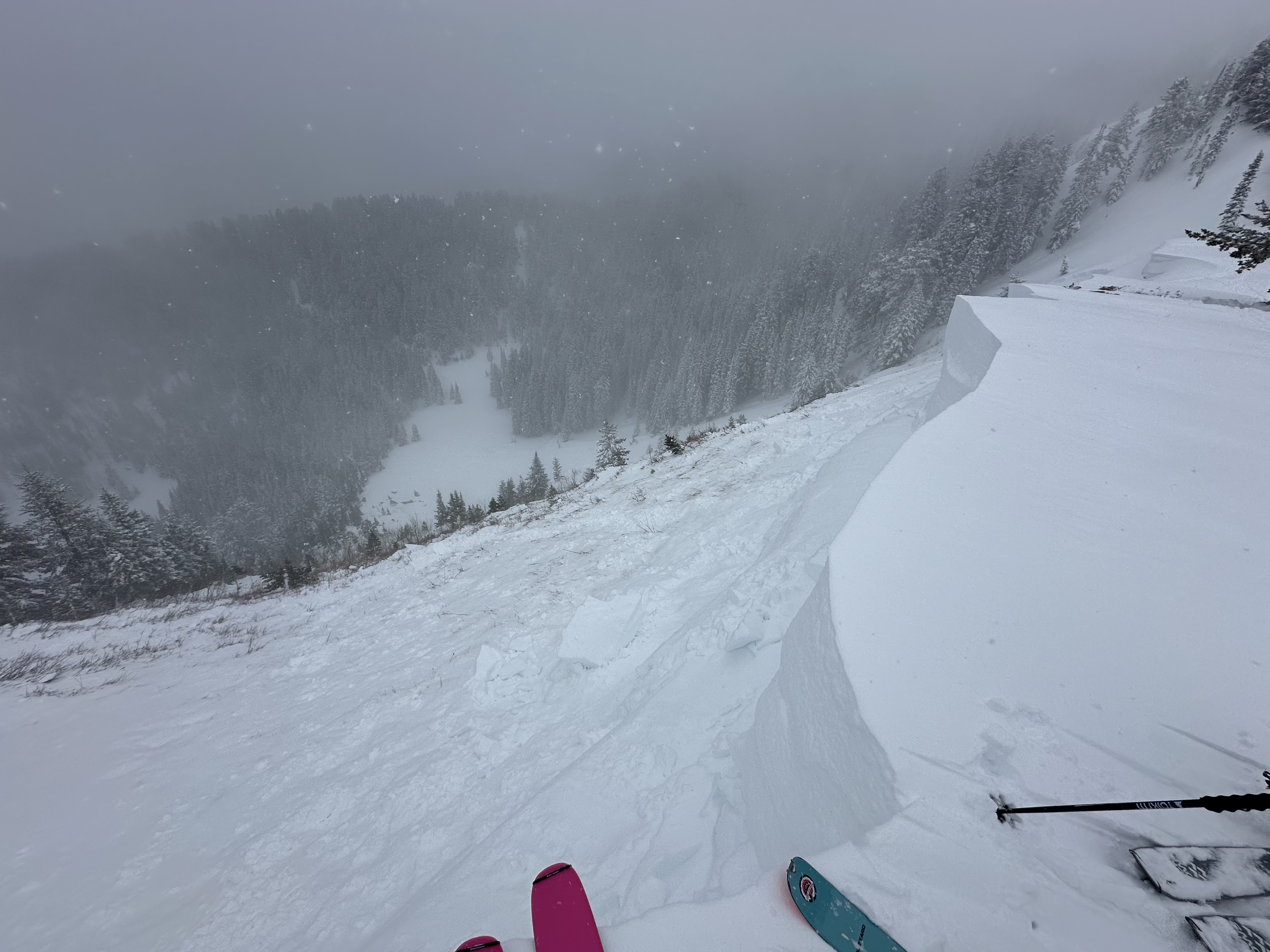
There were no reported avalanches in the central Wasatch backcountry yesterday, but in the upper American Fork drainage above Forest Lake on Sunday, a ski party remotely triggered a cornice fall which in turn triggered a MONSTER avalanche to the ground. The hard slab avalanche failed on a persistent weak layer of early season depth hoar 4-6' deep (width unknown) on a steep northeast facing slope at 9200'. In a heavily wind loaded part of the crown-face, the depth was estimated at 15' deep. (Unsure of terrain? Check the WBSkiing map and search for Peak 9851' near Terraces, just west of Mill Canyon Peak.)
❄️ Ski areas noted shallow soft slabs of wind drifted snow in the upper elevations. Other observers noted minor sluffing in the recent snow. Punchy wet conditions may exist in the lowest elevations.

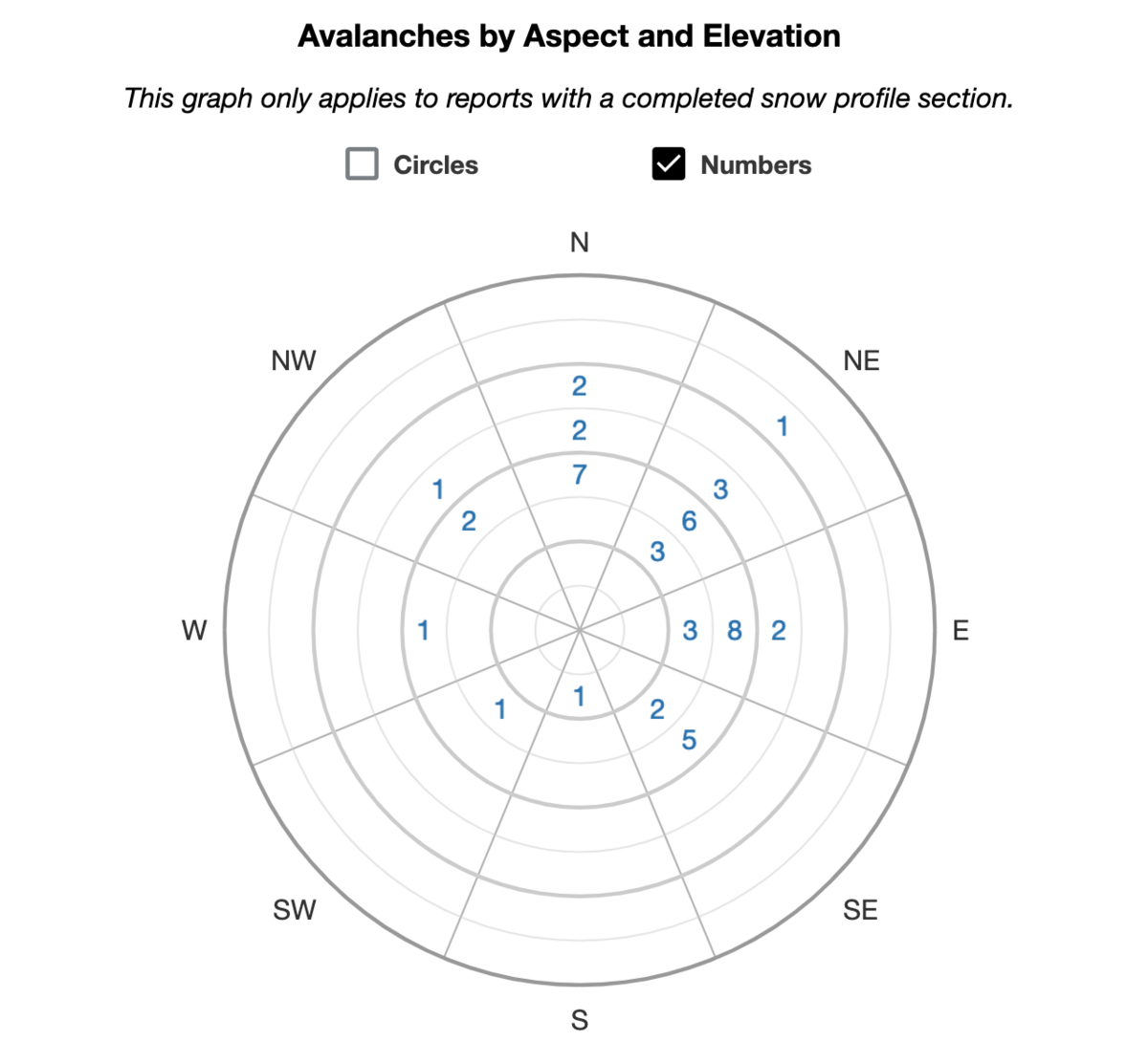
Be sure to check all the avalanche activity HERE.
Ad
Avalanche Problem #1
Persistent Weak Layer
Type
Location
Likelihood
Size
Description
Your main concern is triggering a large and unsurvivable hard slab avalanche that fails on weak faceted snow 2-5'+ deep. This weak faceted snow is a persistent weak layer that formed during our extended dry spell in December and was subsequently buried on January 4th. The initial indicator avalanche of this newly buried PWL was just two days later on the 6th in Main Porter Fork of MCC with an upward trend of avalanche activity with additional storms the following week. The world fell apart with an Extreme danger on Sunday Jan 14th with widespread avalanches on many aspects and elevations. Over time, this unstable combination has become more stubborn and yet they are no less deadly. (Again, it only takes a moment to spin through some photos of recent avalanches to see what I mean.) You can see the reported avalanche frequency for the SLC mountains below.

Beyond all the highlight reel avalanches are some booby-trap avalanches that have recently caught my eye from last Thursday and Friday. These PWL avalanches are well off the ridgelines and in the mid-elevation (some low elevation) bands but still large enough to catch, carry, and bury you. Don't let your guard down. Slope angle is slope angle. See this excellent example below from Mineral Fork from Friday - roughly 8800-9000'. Thinner snowpack areas, particularly outside of the Cottonwoods may be the most suspect. Remember avalanches may be triggered from a distance or below. A heat map of PWL avalanches for the SLC mtns from Jan 6th is below.
Additional Information

Forecaster's Corner: Skiing and riding the backcountry during a Considerable avalanche danger that harbors a PWL is tricky. Usually the snow is great and the signs of instability are not as apparent and obvious as during High or Extreme danger. In spite of our better judgment, we can get lured out into steep terrain by other tracks and even get away with a run or two. But it's when most of our accidents and fatalities occur. Over 70% of our fatalities involve a persistent weak layer. If you get caught and carried today, where will you go? What will happen?
General Announcements
This information does not apply to developed ski areas or highways where avalanche control is normally done. This forecast is from the U.S.D.A. Forest Service, which is solely responsible for its content. This forecast describes general avalanche conditions and local variations always occur.