UDOT PLANNED AVALANCHE CLOSURES!!

Forecast for the Salt Lake Area Mountains

Greg Gagne
Issued by Greg Gagne for
Monday, January 21, 2019
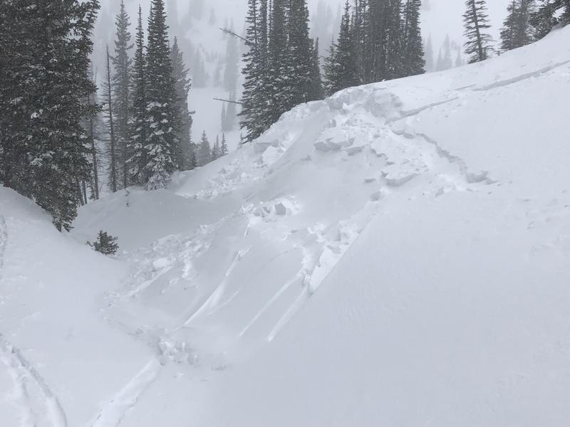
[UPDATED 10:30 AM] Very heavy snowfall this morning! Forecasted updated to HIGH at mid and upper elevations, and CONSIDERABLE at low elevations. Pretty simple avalanche formula as forecasted heavy snowfall and moderate to strong northwest winds will create sensitive storm snow and wind drifts. Both human-triggered and natural avalanches are likely, especially during any period of high precipitation intensity. Avoid being on or underneath slopes steeper than 30 degrees, and avoid avalanche runout zones.
Low
Moderate
Considerable
High
Extreme
Learn how to read the forecast here
Avalanche Warning
AN AVALANCHE WARNING CONTINUES FOR THE MOUNTAINS OF NORTHERN UTAH, where strong winds and heavy snowfall will push to avalanche hazard to HIGH. Both human triggered and natural avalanches are likely. Avoid being on and underneath slopes steeper than 30 degrees.
Special Announcements
On Friday, a skier was killed in an avalanche near Electric Lake on the Manti/Skyline Plateau. Their body was recovered Saturday morning. You can read the updated report - including photos and video from the accident site - by clicking here. The UAC extends our deepest condolences to their family and friends.
Weather and Snow
Mountain temperatures are in the 20’s F and south/southwest winds are moderate to strong, gusting in the 30’s and 40’s mph at mid elevations, and 50’s mph at upper elevations.
A strong cold front is forecasted to enter the Wasatch this morning, with temperatures dropping throughout the day. Winds will switch to the northwest this morning, and persist through much of the day, gusting in the 30’s and 40’s mph at mid and upper elevations.
A cold, moist storm is on our doorstep, with snowfall expected to begin this morning, lasting through most of the daylight hours. We should routinely see snowfall rates of 1”/hr, but a period of heavy snowfall from mid-morning through early afternoon will push rates to 2-3”/hr at times. A brief break is possible late afternoon, with snow showers picking up again this evening. Expected snowfall totals by Tuesday morning are 18-24", with totals possibly approaching 30" in areas favored by northwest flow such as upper Little Cottonwood Canyon.
Recent Avalanches
No backcountry avalanches were reported from Sunday. However control work at a Cottonwood resort pulled out a large avalanche that broke 6' deep on a northeast slope at 10,500'.
Ad
Avalanche Problem #1
New Snow
Type
Location
Likelihood
Size
Description
Forecasted heavy snowfall will create sensitive storm snow today, including storm slabs as well as loose snow avalanches. Human-triggered avalanches are likely, and I am also expecting natural avalanches, especially during any period of high precipitation intensity. Pay attention to rapidly changing conditions, and watch for clues such as cracking or avalanching, even on smaller slopes.
Avalanche Problem #2
Wind Drifted Snow
Type
Location
Likelihood
Size
Description
Strong winds out of the south/southwest created some dense wind drifts at the upper elevations on Sunday, and today's northwest winds will have plenty of new, low-density snow to work with, creating fresh wind drifts on all aspects at the mid and upper elevations. Some of these drifts may be 2' thick in places. Also watch for sensitive cornices along upper elevation ridgelines, especially on aspects facing north through east.
Avalanche Problem #3
Persistent Weak Layer
Type
Location
Likelihood
Size
Description
While the faceted weak layers in our snowpack continue to gain strength and adjust to the recent loading of storm and wind-driven snow, they still cannot be completely trusted. I dug several pits over this past weekend, especially in areas that had what we considered a thin snowpack (< 3') prior to last week's storm. My stability tests were showing these weak layers to be gaining strength, but Drew and Don Carpenter still found pre-Christmas facets reactive in their field work on Sunday (observation). With so many avalanches occurring this past Thursday, it is possible some slopes have repeated (some are habitual offenders from all season long), exposing a thinner snowpack that may be reactive to today's new load of storm and wind-driven snow.
Additional Information
We have received several excellent field observations and reports of avalanches the last several days from "outlying areas" including the Sessions mountains, City Creek and Lambs Canyons, such as this remotely-triggered slide on near Grandview Peak in the Sessions (observation). As low elevation snowfall has helped fill in areas outside of the central Cottonwood zones, many are choosing to recreate in these outlying areas. Just because you aren't in, say Cardiac Bowl, doesn't mean you can let your guard down. Treat all steep slopes in outlying areas as potential avalanche terrain!
General Announcements
This information does not apply to developed ski areas or highways where avalanche control is normally done. This forecast is from the U.S.D.A. Forest Service, which is solely responsible for its content. This forecast describes general avalanche conditions and local variations always occur.