Join us at our 2nd Annual Blizzard Ball

Forecast for the Salt Lake Area Mountains

Nikki Champion
Issued by Nikki Champion on
Tuesday morning, January 19, 2021
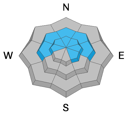
The avalanche danger is MODERATE on all steep upper elevation slopes. The avalanche danger is also MODERATE on steep mid-elevation slopes facing west, through north, through east. Human-triggered avalanches are possible on these slopes, especially if they have a denser slab of wind-drifted snow on top of weaker, faceted snow. Any avalanche triggered could be 1-3' deep and over 100' wide. These avalanches may be triggered remotely and from lower-angled terrain below.

All other aspects have a LOW avalanche danger.
Low
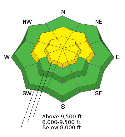
Moderate
Considerable
High
Extreme
Learn how to read the forecast here
Special Announcements
Thanks to the generous support of our local resorts, Ski Utah, and Backcountry, discount lift tickets are now available. Support the UAC while you ski at the resorts this season. Tickets are available here.
Weather and Snow
This morning, under mostly clear skies temperatures are in the low teens F at trailheads and single digits F at upper elevations. Last night winds switched from being Northwesterly, to Easterly and gusted near 70 mph. Since then, the winds have decreased and are currently blowing 20-30 mph and gusting up to 45 mph at upper elevations.
The change in winds will have changed the riding surface, moved a lot of snow around on the ridgelines, and deposited snow in unusual terrain features. Yesterday we picked up about 1-3" of new snow across the Central Wasatch.
Today, the weak storm system from yesterday will continue to the Southwest allowing for the dry easterly flow to continue along ridgelines. As this system departs the region, the ridgetop winds will decrease and eventually shift back to Southeasterly. Conditions will be sunny, temperatures will be in the mid-20s to low 30s F, and winds will average 10-20 mph at mid-elevations with gusts below 25 mph, and at upper elevations average 15-25 mph with gusts up to 50 mph.
A bit of good news - if the extended weather models are correct, we have a decent looking storm slated for the weekend. We are all keeping our fingers crossed that the models don't change.
Recent Avalanches
Yesterday there were no new avalanches reported in the backcountry.
You can find all the backcountry observations HERE.
Ad
Avalanche Problem #1
Persistent Weak Layer
Type
Location
Likelihood
Size
Description
The main problem continues to be the poor snowpack structure that remains throughout the entire Wasatch Range, this make up of strong snow over weak faceted snow. The problem primarily exists on shady slopes at the mid and upper elevations, where a strong slab of snow can release and fail in the weak faceted snow below. Snowpit results, significantly fewer reports of cracking and collapse and lack of avalanche activity show that the likelihood of triggering an avalanche is decreasing, however, it is still not zero.
We get it, the best coverage and riding seems to be in steep north-facing terrain. While it could be the best riding, this terrain is exactly where the avalanche danger is heightened. As soon as you decide to ride steep northerly facing terrain at the mid and upper elevations, you are rolling the dice as triggering a slab avalanche 1-3’ deep remains possible. This is just the type of problem I don’t want to test the boundaries of, my strategy will be to continue avoiding this steep terrain until the weak layer of faceted snow is buried so deeply that it no longer is a problem, or melts in the spring - whichever comes first.
Another thing to think about: While we haven’t had a large snow load on the weak faceted snow in over a week, wind drifted snow can act as a load to the snowpack - even when it’s not snowing. Over the past 6 days, we have had high winds and increased wind loading. The ESE winds will have loaded NW facing terrain and anywhere recently wind drifted snow sits atop the weak faceted snow will have an increased load.
Avalanche Problem #2
Wind Drifted Snow
Type
Location
Likelihood
Size
Description
Over the last few days the winds have been cranking, and last night the winds changed from Northwesterly to Easterly changing the aspect that will have signs of obvious wind loading. The combination of these sustained days of wind and few new inches will have allowed for new wind drifts to form. While there wasn’t a ton of new snow to move around, with such high winds any snow that was available to be transported, will be transported at the mid and upper elevations. Last night the winds switched to Easterly which will have loaded unusual terrain features compared to the Northwesterly winds we have been experiencing. Sustained high winds can deposit snow around terrain features on almost any aspect, this is known as cross-loading. For this reason, I would expect to find sensitive slabs of wind drifted snow at all mid and upper elevation slopes, especially along with terrain features such as ridgelines, sub ridges, and gullies.
The winds have backed off a bit this morning, but even with a few elevated gusts throughout the day, these slabs will become more firm and cohesive. This can allow you to travel out farther onto the slope before it breaks, and can fail larger and wider than expected. Triggering an avalanche that initially fails in the wind-drifted snow will likely break down more deeply into the weak faceted snow below.
Today continue to look for slopes with any signs of wind drifted snow, such as cracking, hollow noises, and pillow-shaped snow, and avoiding those slopes.
General Announcements
Please visit this website with information about Responsible Winter Recreation by the Utah Office of Outdoor Recreation.

This information does not apply to developed ski areas or highways where avalanche control is normally done. This forecast is from the U.S.D.A. Forest Service, which is solely responsible for its content. This forecast describes general avalanche conditions and local variations always occur.