Join us at our 2nd Annual Blizzard Ball

Forecast for the Salt Lake Area Mountains

Trent Meisenheimer
Issued by Trent Meisenheimer on
Saturday morning, January 18, 2025
The avalanche danger is MODERATE on all aspects at the mid-and upper elevations where there are fresh soft slabs of wind-drifted snow. Also, be on the lookout for dry-loose avalanches in steep terrain where the low-density new snow could run fast and far, packing a punch.
The avalanche danger is MODERATE on mid and upper elevation aspects facing northwest through north and east where it is possible to trigger an avalanche failing in a buried persistent weak layer 2 to 4 feet deep. Don't let powder fever cloud your judgment today. Human-triggered avalanches are possible.
Low
Moderate
Considerable
High
Extreme
Learn how to read the forecast here
Special Announcements
Join the UAC at Deer Valley on January 30th for the 2nd Annual Blizzard Ball Gala. The night will be full of fun including delicious cuisine, live music, an auction, and presentation by Bruce Tremper.
Weather and Snow
This morning, it's snowing and favoring the Upper Cottonwoods! Overnight totals are 4 to 10 inches of new snow with 0.16 to 0.44 inches of snow water equivalent (swe). The northwest wind continues to blow at speeds of 5-15 mph with gusts into the 20s. Above 10,500', the wind is blowing a bit harder from the northwest at speeds of 30-37 mph with gusts into the 40s and 50s. Let's not forget about the mountain temperatures; they're cold! temperatures range from 1 to 12 °F with wind chills ranging from -3 to -31 °F. Brrrrr.

Today, we should see continued snowfall over the Cottonwoods for most of the morning. All the models I looked at show us drying out around noon. One model did keep light snowfall going into the afternoon. We should see an additional 1 to 5 inches of new snow throughout the day, bringing totals to 6-12 inches of low-density snow. Because everyone loves a high-end forecast, favored areas could squeak out a little more snow depending on orographic lift and flow. Here we could end up at 14 inches of new snow or more. The northwest wind will stay elevated throughout the day with speeds of 5-10 mph, gusting into the 20s. Temperatures will remain cold, topping out at 11-16 °F. Stay warm.
Recent Avalanches
No new human-triggered avalanches were reported yesterday. Mark White did find a glide avalanche in Broads Fork. Over the past several days, we've received several excellent observations, which you can read by clicking the button below.
Ad
Avalanche Problem #1
Wind Drifted Snow
Type
Location
Likelihood
Size
Description
Yesterday, the northwest wind picked up around 10:00 am, averaging 15-25 mph with gusts into the 20s and 30s throughout the day and night. This morning the wind is still elevated and will remain elevated throughout the day. Because of this, I would expect sensitive drifts of wind blown snow across all mid- and upper elevations. These avalanches will be soft slabs of wind-drifted snow that could be extra sensitive because they either formed over a slick sun crust (sunny side) or our weak and faceted snow surface (shady side). These avalanches could be 1-2 feet deep and large enough to bury a person.
On northerly facing terrain, any avalanche you trigger has the chance of stepping down into deeper weaker layers. Out of the wind, I would look for dry-loose avalanches in all steep terrain. The low-density new snow could run fast and far, packing a punch.
Avalanche Problem #2
Persistent Weak Layer
Type
Location
Likelihood
Size
Description
It's only been one day since we've had someone trigger a slab avalanche on our buried persistent weak layer. On Tuesday, Wednesday, and Thursday, we saw slab avalanches remotely triggered and human triggered on this weak layer. For me, I need more than a day of no avalanche activity before I trust this problem. Eric Trenbeath UAC Forecaster is visiting from Moab and summarized this problem well:
"I've been observing the Wasatch snowpack history from afar and this was my first day out in the field up here. It's my impression that the PWL presents the greatest danger on steep northerly aspects where the snowpack is right around 100 cms or less. Terrain also seems to play a significant roll. In addition to steepness, a certain amount of "scrappyness" or complexity seems to be a contributing factor as well. Steep, rocky slopes with convex features, or even sparse trees seem the most likely areas to trigger an avalanche. Broad, planar slopes, especially those with a deeper snowpack seem less likely. It is, however, a bit like rolling the dice. For our part, we continued to avoid slopes much more than 30 degrees".
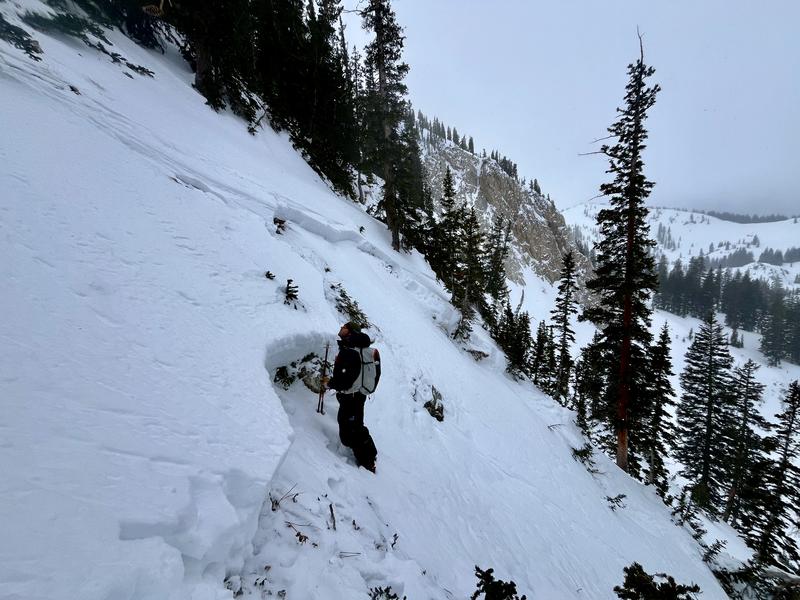
Photo: N. Grainger showing Dave Kelly looking at the human triggered avalanche in Martha Bowl.
Additional Information
Nikki's Week in Review is available. Read this invaluable resource as part of your regular planning.
General Announcements
This information does not apply to developed ski areas or highways where avalanche control is normally done. This forecast is from the U.S.D.A. Forest Service, which is solely responsible for its content. This forecast describes general avalanche conditions and local variations always occur.