Donate Now to Our Year End Campaign!

Forecast for the Salt Lake Area Mountains

Drew Hardesty
Issued by Drew Hardesty on
Friday morning, December 26, 2025

A MODERATE avalanche danger exists in the upper elevation bands on west to north to east facing slopes. Here, it's possible to trigger a slab avalanche that fails 1-2 feet deep on a persistent weak layer (PWL) of sugary, faceted snow. Collapsing and cracking may or may not be present to warn of the danger.

By late afternoon to early evening, you may encounter loose snow sluffs and pockety slabs of wind blown snow IF we see the higher end of forecast snowfall.

Low
Moderate
Considerable
High
Extreme
Learn how to read the forecast here
Weather and Snow

The Grinch - 1

The Wasatch - 0

Mark White and Greg Gagne, with more than 70 years combined of backcountry skiing in the Wasatch, agreed it was the worst skiing of their lives yesterday. There is now a connoisseur's buffet of supportable, breakable, and trapdoor crusts (Mark White photo below) on every aspect and at every elevation. The good news? Just wait a day or two - Santa's mounting a comeback (he's been here for years) and we'll see a return to winter and a return to the Greatest Snow on Earth.

Christmas Eve into Christmas day brought heavy rain to near 10,000' with some liquid water touching the highest peaks. The upper Cottonwoods picked up just over an inch of water, but only a measly inch of new snow for all the trouble. The Park City ridgeline picked up about 0.60" of precipitation. And - adding insult to injury - total depth snow stakes lost a couple inches of snow: there's now only 15-30" on the ground.

But today's a new day. Currently, It's lightly snowing with temps in the low 20s up high, the low 30s down low. Winds are from the southwest, blowing 20-30mph with gusts to 55.

Look for overcast skies with light snow accumulations in the afternoon. Perhaps 1-4" by supper. Temps will be in the mid-20s up high, the mid-30s down low. Winds will remain out of the southwest, blowing 25-35mph along the high peaks. A COLD FRONT - two of them, actually - will barrel through the Wasatch tonight and again Saturday night and I expect we'll see storm totals of up to 12-18" (perhaps an inch of water). Mountain temps plummet to the low single digits Saturday night; so Yes, Virginia, there really is a Santa Claus. He was just running a touch late.

The Week in Review is hot off the press. You can find it HERE.

Recent Avalanches

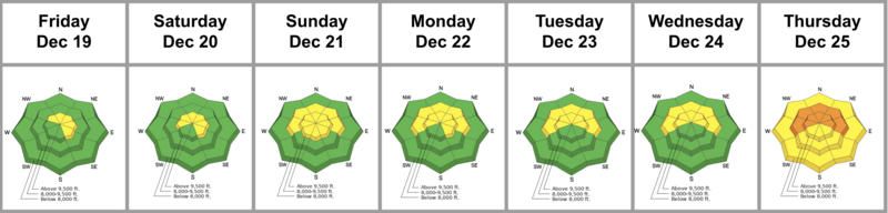
The only avalanches we heard about yesterday were some wet loose sluffs cascading out of the highest, northerly terrain when rain fell on the cold, dry snow. That's all.

Read all recent observations HERE.

Avalanche Problem #1
Persistent Weak Layer
Type
Location
Likelihood
Size
Description

There is a fair bit of capital U Uncertainty here in regards to the snowpack. The warmth (over the past week(s) and rain has dampened the snow from the top down and the bottom up and we have an 'isothermal' snowpack in many areas. The lingering problem, however, is that the poor structure still exists and I think it's still possible for someone to trigger an avalanche that fails on one of two layers of faceted snow (PWLs). That is, if they can collapse the superficial crusts. Mark White found this poor and unstable structure along the Park City ridgeline yesterday (video below) on northwesterly facing terrain at 9500'. Time will tell how this whiplash in temperatures will affect the structure in the coming days. What I will say is that the risk matrix for getting on steep polar terrain today registers as moderate risk but with very low reward.

And...just to add more complexity to the overall picture: rain crusts are notorious for both connecting slopes together AND fostering the development of weak, faceted grains. We'll be watching with interest.

General Announcements

This information does not apply to developed ski areas or highways where avalanche control is normally done. This forecast is from the U.S.D.A. Forest Service, which is solely responsible for its content. This forecast describes general avalanche conditions and local variations always occur.