
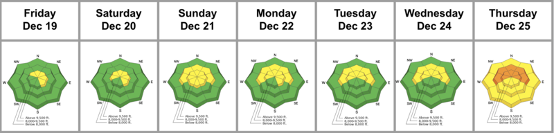
Summary: Atmospheric rivers stormed through the West, but generally stayed to the north of us. Over the week, we experienced record or near-record temperatures along with moderate to strong winds from the west, but at least we did pick up a few inches of very dense snow - derisively referred to as “graupel slush” - Friday into Saturday. The overall avalanche danger tilted between LOW and MODERATE with the primary concerns revolving around the buried early season PWL of facets; soft slabs of wind drifted snow; and wet avalanches (wet sluffs). Christmas Day dawned with a CONSIDERABLE danger with the anticipated storm.
Friday: A leftovers-from-the-north storm arrives early evening and lasts through part of Saturday, providing the aforementioned “graupel-slush”. Regardless, the glass-is-half-full crowd find much improved skiing and riding conditions on a supportable base.
Saturday: Overcast. Forecasters Trent Meisenheimer and Brooke Maushund walk through slush to gain the upper reaches of Days Fork in BCC to find good skiing! Poor structure is still evident in mid and upper-elevation polar aspects…and conservative terrain choices for our staff reflect this.
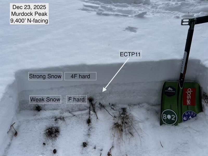
Sunday: Light rain to 9500’. A backcountry party along the far north end of the Park City Ridgeline (Murdock Peak) remotely triggers an avalanche to the ground 1’ deep and 50’ wide on a steep northeast-facing slope at 9400’. They noted no obvious signs of instability prior to avalanche release. This is the first reported avalanche on the basal facets since December 7th.
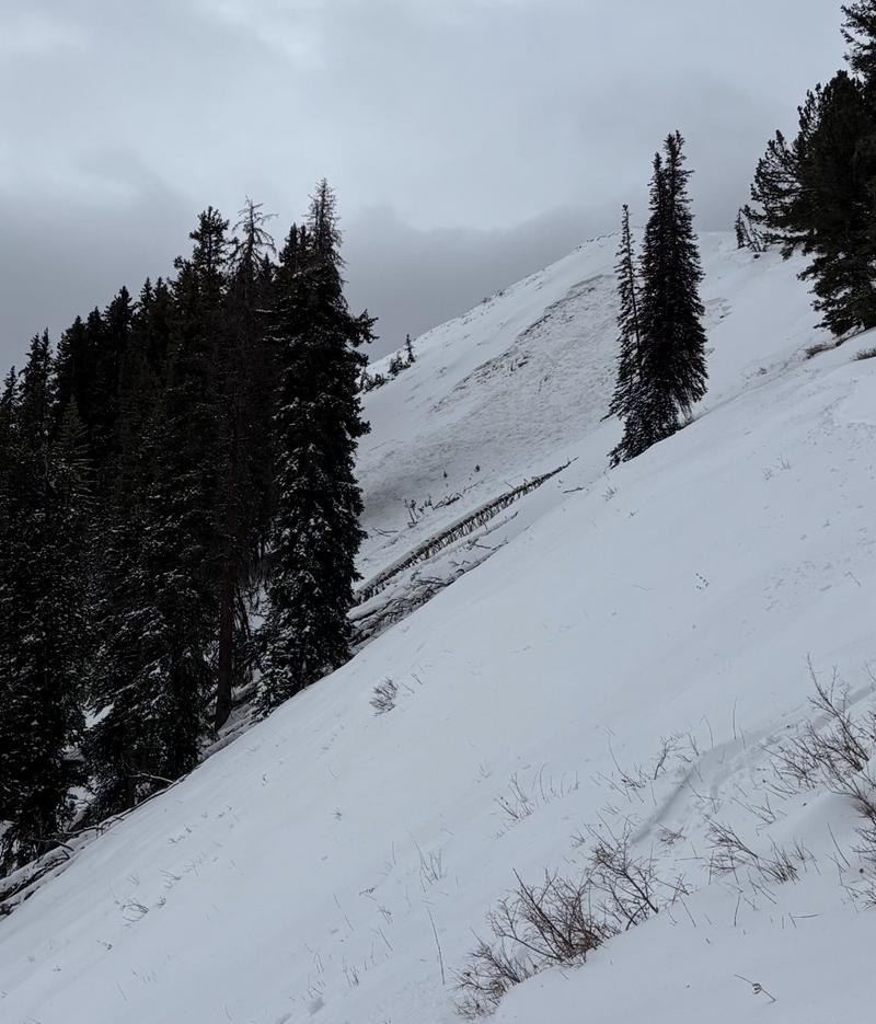
Monday: Warmth continues.. Forecaster Greg Gagne, with assistance from Park City Mountain Resort avalanche workers, investigates the avalanche on Murdock Peak. They find dry depth hoar as the failure plane beneath the cohesive soft slab…with complementary tests demonstrating very unstable snow (ECTPV) in adjacent terrain. (Greg Gagne video below). Ski areas close some terrain due to wet snow avalanche concerns.
Tuesday: Warmth continues as mountain temperatures reach a scalding 46°F (!) at the Alta Guard station in upper LCC (8799’).
Wednesday: Warmth continues, and moderate to strong winds blow out of the south ahead of the next warm atmospheric river event. Median statewide snow-water-equivalent sits at 53%. All eyes are on Santa as winter recreationists, farmers, and water planners all have the same thing on their wishlists. Avalanche teams in upper LCC manage to trigger a wind-blown hard slab that fails on facets on steep northeast-facing terrain at 10,200’. Certainly more portent of what’s to come IF the storm verifies.
Thursday: The Grinch and the naughty Elves steal Christmas. The Cottonwoods pick up an inch of water, but the rain-snow line is up to (and perhaps over) 9500’. The Park City ridgeline garners 0.5-0.65” of precipitation but no one anywhere reports more than two inches of snow for all the effort. Worried about the new load and the moderate to strong winds from the south, the overall danger jumps to CONSIDERABLE. We did hear about a couple of natural wet loose sluffs as rain touched the highest elevation northerly aspects, triggering wet loose sluffs. By the afternoon, the Wasatch is plastered in a mess of supportable and breakable rain crusts and unsupportable glop down low. Those curious about “boot-penetration” found that they’d sink to the ground after clicking out of their skis or boards, or getting off their machine. Mark White and Greg Gagne - with over 70 years of backcountry skiing in the Wasatch between them - report the worst skiing they've ever experienced in the Wasatch. All eyes are on the weekend storm, with a return to "real" winter.
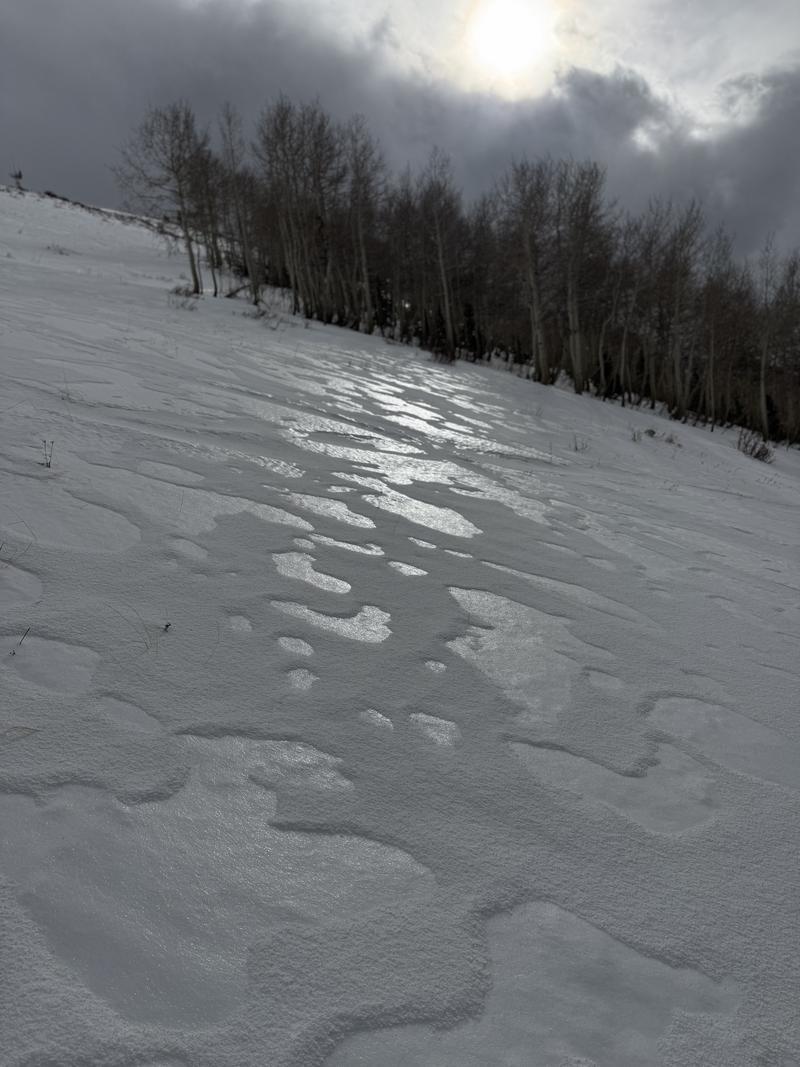
Mark White photo of the slick rain crusts with a dusting of graupel above..


