Forecast for the Provo Area Mountains

Mark Staples
Issued by Mark Staples for
Wednesday, April 5, 2023
Expect the unexpected. The avalanche danger remains HIGH on all aspects and elevations today. Soft slab avalanches in the new snow are running farther and faster and breaking over wider areas than normal. These are unprecedented conditions.
Avalanches will happen in the foothills not just in the canyons and higher elevations.
With so much snow, also watch out for roof avalanches near structures, and be extra cautious near tree wells or any feature where you could fall head first and be unable to get out.
Low
Moderate
Considerable
High
Extreme
Learn how to read the forecast here
Avalanche Warning
What
The avalanche danger for the warning area will be HIGH today.
When
In effect from 6am MST this morning to 6am MST Thursday
Where
For the mountains of Northern Utah and Southeast Idaho including the Wasatch Range and the Bear River Range.
Impacts
Recent heavy accumulations of snow and drifting have created widespread areas of unstable snow. Long running natural and human triggered avalanches are likely. People should avoid being in backcountry avalanche terrain, (off of and out from under slopes steeper than 30°), and stay clear of avalanche runouts. Be careful near any structures due to roof avalanches.
Special Announcements
The report for the Pole Canyon Accident is available HERE. Thank you to the people involved for sharing so much information so that we can all learn from this accident and come home safely to our loved ones.
Weather and Snow
It's cold and it's still snowing. Unreal!
Overnight the Provo area mountains received an additional 6 inches of snow bringing the total snow since Sunday eveing up to about 20 inches. There is some variability of snowfall and I suspect there are places that have received more than this.
Temperatures range from the mid teens to single digits F. Winds this morning most ridgelines are blowing from the west-northwest at 10 mph gusting to 15 mph. At the highest elevations, winds are gusting 33-42 mph.
For today, temperatures will remain cold and snowfall will continue. Lake effect snowfall should taper off this morning, but later this morning snowfall should kick in again due to convective (upward moving) atmospheric conditions. Total snowfall today is a bit uncertain but should be less than yesterday and overnight with maybe an additional 2-5 inches but more is possible. Winds will remain similar to what they are this morning.
Heads up - things may warm up considerably this weekend. Stay tuned.
Recent Avalanches
Soft slabs of new snow were very sensitive yesterday with a widespread avalanche cycle of natural avalanches in Little Cottonwood Canyon including several close calls with avalanche professionals.
Greg was 
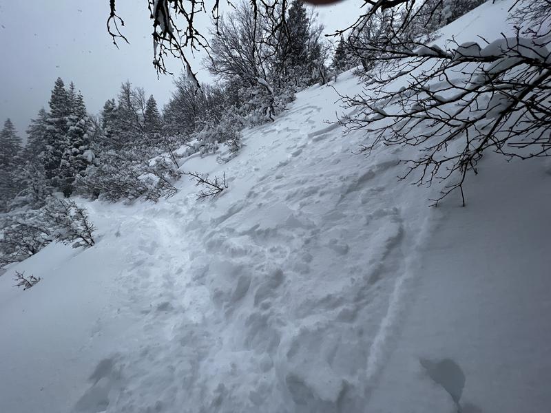
skiing in Mill Creek Canyon in a place he has traveled literally hundreds of times, and he turned around because he was triggering so many small avalanches on small terrain features where he normally doesn't see them.
Another group was skiing at low elevations near Mt Olympus (Read this ob!) and remotely triggered several avalanches up to 200 ft wide in the new snow.
Vegetation and terrain features are all buried deeply which has allowed avalanches to break wider and further than normal.
Check out all observations HERE.
Ad
Avalanche Problem #1
New Snow
Type
Location
Likelihood
Size
Description
There have and will continue to be soft slab avalanches occurring in the new snow that has fallen since Sunday evening. Areas with the most snow will have the greatest danger.
Normally this time of year the name of the game is storm riding because snow conditions deteriorate when the sun comes out. Unfortunately, the best advice for today will be to avoid all avalanche terrain and stay far away from runout zones.
Photo below from Greg's field day in Mill Creek Canyon. It's a small avalanche on small terrain which tells us what to expect on bigger terrain.
Avalanche Problem #2
Wind Drifted Snow
Type
Location
Likelihood
Size
Description
Winds haven't been blowing too strong, but they have have been just right at most ridgelines to steadily transport snow and create soft slabs of wind drifted snow.
Cornices are massive and are continuing to grow larger. When these break they are a significant hazard by themselves. A group found sensitive cornices yesterday above East Canyon off of Parleys Canyon. It's very risky to mess with cornices as the often break much further back than you expect - just stay away from them.
Additional Information
GET READY - Conditions later this week and into this weekend will shift from cold wintry conditions to very warm spring conditions. The snowpack does not like rapid change. I don't really know what exactly to expect, but I'm certain we'll see lots of wet avalanches this weekend.
General Announcements
This information does not apply to developed ski areas or highways where avalanche control is normally done. This forecast is from the U.S.D.A. Forest Service, which is solely responsible for its content. This forecast describes general avalanche conditions and local variations always occur.