Forecast for the Provo Area Mountains

Drew Hardesty
Issued by Drew Hardesty for
Wednesday, April 3, 2024
The danger for wet avalanches will rapidly rise to CONSIDERABLE on all steep east to south to west facing aspects this morning. With direct sun and skyrocketing temperatures, dangerous wet avalanche conditions can be expected on and below steep solar terrain. Mid and lower elevation shady terrain will also produce wet slides and a MODERATE danger with today's heat.
Cornices and roof avalanches are objective hazards for today.
Low
Moderate
Considerable
High
Extreme
Learn how to read the forecast here
Special Announcements
Support the UAC website backend platform to ensure the ongoing security of the website and the data stored on the site rebuild by donating to our spring campaign.
Weather and Snow
Skies are clear.
Winds are light from the northwest, blowing 5-10mph on all but the highest peaks, where they're blowing 15-20mph.
Mountain temperatures are 10-15°F warmer than they were at this time yesterday with current overnight "lows" in the upper 20s to low 30s. I do expect a refreeze of the snow, but it'll be fleeting with a shorter window to recreate on and below steep solar aspects today. Beyond that window, the snow will become wet, punchy, unsupportable and dangerous for wet avalanches.
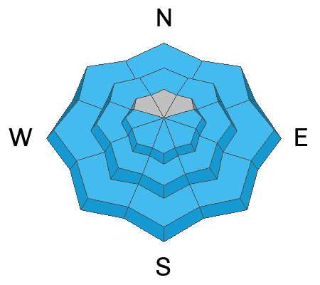
All aspects and elevations but high true north will have varying degrees of supportable to breakable to trapdoor crust this morning.

For today, we'll have sunny skies, light winds backing to the southwest, and mountain temperatures skyrocketing to the low 50s down low, the mid to upper 30s up high.
The Outlook: Winds will start to increase from the southwest tonight and Thursday ahead of a fairly potent looking storm arriving Friday. Relief in the form of a cold front arrives early afternoon Friday with snowfall expected through the weekend with 10-16" expected.
Recent Avalanches
Wet avalanches: With skyrocketing temperatures and direct sun, wet avalanches cascaded down the steepest sunlit terrain yesterday, leaving impressive debris piles. Those overstaying their welcome on these sunlit slopes by midday also found it easy to trigger wet loose avalanches and it paid off to move out of the fall line to avoid the cement mixer.
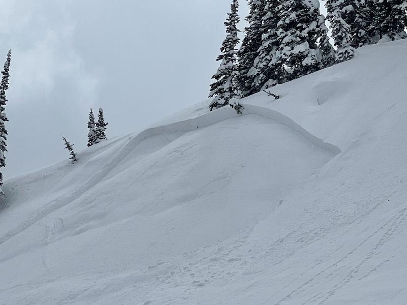
Soft slabs: A few soft slab avalanches occurred since Sunday in steep alpine terrain. Most of these were 8-16" deep and up to 150' wide. Most of these have likely healed with natural settlement and bonding. Matt Wiest photo below from the Ant Knolls.
⚠️ Thanks to those who have called the local ski area dispatch to report avalanches in areas adjacent to ski areas or above the road. This prevents SAR teams from unnecessarily responding in potentially dangerous situations for no reason. MORE INFO
Check out all avalanches and observations HERE.
Ad
Avalanche Problem #1
Wet Snow
Type
Location
Likelihood
Size
Description
Wet Avalanches: MUCH warmer temperatures overnight and this morning will result in a much narrower window to recreate on and below all steep solar aspects and some mid/low elevation polar aspects today. Early starts are key and you'll probably want to be off of this terrain by mid-to late morning. Pay attention to the crusts and snow under your feet or ride. Roller balls, dripping water off of rocks, and your boots or skis sinking into the surface snow are signs it's time to move to lower angle terrain or head to the car.
Beyond this window, skyrocketing temps and direct sun will lead to unstable and dangerous wet avalanche conditions. Natural and human triggered avalanches are expected.

Cornices: Avoid traveling on or underneath large cornices, as they may become sensitive to heating and collapse naturally onto the slope below.
Roof Avalanches: With warming temperatures and a lot of cold snow available, roof slides are a concern. Be aware of adults working solo outside or children playing, as these are the people most susceptible to roof slides.
Additional Information
We have been hearing about a few close calls between backcountry parties recently. PSA below -
General Announcements
This information does not apply to developed ski areas or highways where avalanche control is normally done. This forecast is from the U.S.D.A. Forest Service, which is solely responsible for its content. This forecast describes general avalanche conditions and local variations always occur.