Forecast for the Provo Area Mountains

Drew Hardesty
Issued by Drew Hardesty for
Thursday, April 4, 2024
The danger for wet avalanches will rapidly rise to CONSIDERABLE on all steep east to south to west facing aspects this morning. With direct sun and skyrocketing temperatures, dangerous wet avalanche conditions can be expected on and below steep solar terrain. Mid and lower elevation shady terrain will also produce wet slides and a MODERATE danger with today's heat and greenhousing. You may also find an elevated hazard for shallow wind drifted snow avalanches along the highest elevation bands today.
Cornices, roof avalanches and glide avalanches remain significant objective hazards.
Low
Moderate
Considerable
High
Extreme
Learn how to read the forecast here
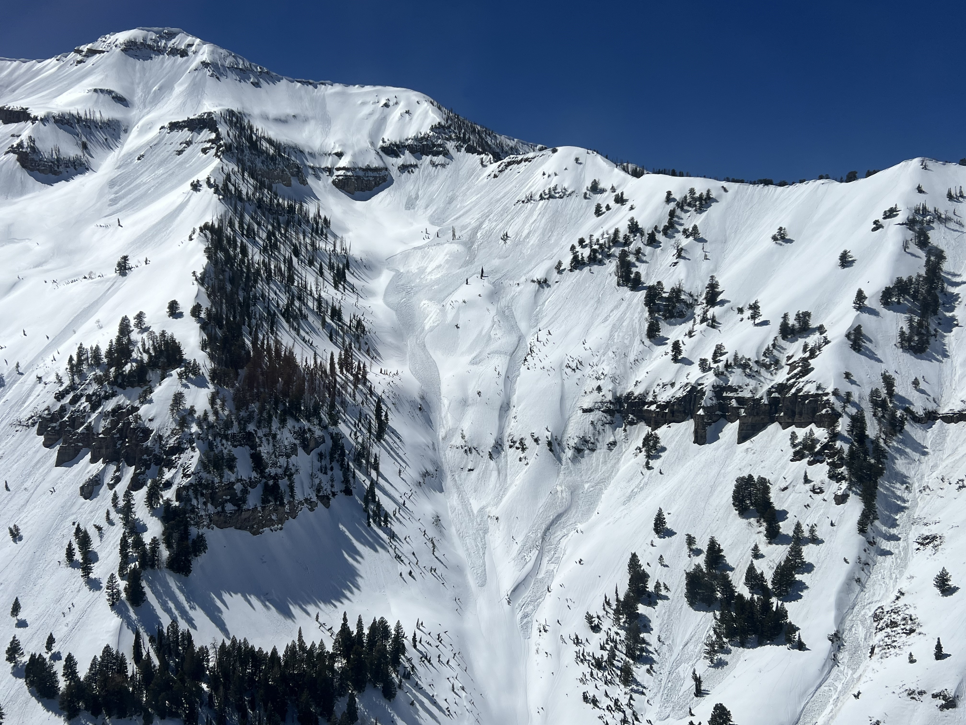
Special Announcements
Support the UAC website backend platform to ensure the ongoing security of the website and the data stored on the site rebuild by donating to our spring campaign.

Do We Let Our Guard Down in the Spring? --- UAC Avalanche Education coordinator McKinley Talty looked at the numbers....and his blog just might surprise you.
Weather and Snow
Skies are clear.
But not for long. We'll see increasing high clouds as a hint of things to come.
The winds from the south picked up overnight, blowing 25-30mph with gusts to 40. Even some unobstructed mid-elevation ridgeline anemometers are registering hourly averages of 25-30mph.
Mountain temperatures remain sweltering with another night of a poor refreeze, if that. Overnight "lows" in the low 40s are again 5-10° warmer than 24 hours ago, which were 10-15° warmer than the night before. (Note Timp Divide snotel (elev. 8170') temperatures below. The diurnal temperatures swings are obvious, but so is the trend. Many total depth snow stakes lost 4-6" in the last 24 hours alone.

For today, we'll have increasing high clouds and possibly some greenhousing. Winds from the south will blow 30-40mph with gusts to 50+. Temperatures will rise to the mid-50s down low, the mid-40s up high. We *may* experience another dust event if the winds present more of a southwesterly direction. It won't be pretty.
We'll have another night of warm temperatures tonight ahead of tomorrow afternoon's cold front and extended snowfall through the weekend. The model runs have trended snowier with each run...and many areas will pick up 8-12" of snow and perhaps 12-18" in areas that benefit orographically from a west-southwest flow. It does look like the winds remain brisk through Sunday. This should be a decent storm for us and did I mention McKinley Talty's essay, Do We Let Our Guard Down in the Spring?
Recent Avalanches
Wet avalanches: With skyrocketing temperatures and direct sun, wet avalanches again cascaded down the steepest sunlit terrain yesterday, leaving impressive debris piles. Some of these wet loose slides pried out wet slabs below, particularly on easterly facing terrain along the Cascade ridgeline.
Powderbird photo
Don't underestimate the power of wet avalanches. See Connor Worth's footage of a natural slide out of White Pine couloir on the north side of LCC.
Check out all avalanches and observations HERE.
Ad
Avalanche Problem #1
Wet Snow
Type
Location
Likelihood
Size
Description
Wet Avalanches: MUCH warmer temperatures again overnight and this morning will result in a much narrower window to recreate on and below all steep solar aspects and - especially with some greenhousing - some mid/low elevation polar aspects today. Early starts are key and you'll probably want to be off of this terrain by mid-morning. Pay attention to the crusts and snow under your feet or ride. Collapsing is a yellow flag. Roller balls, dripping water off of rocks, and your boots or skis sinking into the surface snow are signs it's time to move to lower angle terrain or head to the car. Note that some wet avalanches, particularly on easterly aspects, may gouge more deeply into deeper layers of wet, unconsolidated snow, producing larger debris piles.
Beyond this window, skyrocketing temps and direct sun will lead to unstable and dangerous wet avalanche conditions. Natural and human triggered avalanches are expected.

Cornices: Avoid traveling on or underneath large cornices, as they may become sensitive to heating and collapse naturally onto the slope below.
Roof Avalanches: Roof slides are a concern. Be aware of adults working solo outside or children playing, as these are the people most susceptible to roof slides.
Avalanche Problem #2
Wind Drifted Snow
Type
Location
Likelihood
Size
Description
Winds will find a way. I am always surprised at how - when it seems there is little snow available for transport - the winds find a way to strip and erode even superficial crusts and then transport and deposit snow into cohesive slabs. If they're out there, you're most likely to find them on northerly terrain in the upper elevations.
General Announcements
This information does not apply to developed ski areas or highways where avalanche control is normally done. This forecast is from the U.S.D.A. Forest Service, which is solely responsible for its content. This forecast describes general avalanche conditions and local variations always occur.