Forecast for the Provo Area Mountains

Dave Kelly
Issued by Dave Kelly for
Monday, April 17, 2023
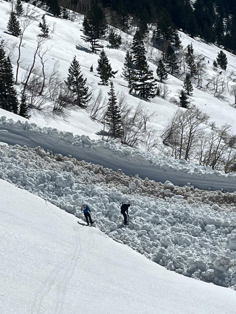
The avalanche danger will rise to MODERATE on solar aspects and low elevation northerly facing slopes as springtime sun and warm temperatures heat the surface.

The avalanche danger is LOW on upper and mid-elevation north facing slopes that will receive less daytime sun. If the wind does not keep the snow surface cool there is a chance that the avalanche danger will rise to CONSIDERABLE on solar aspects this afternoon.

Be prepared to adapt to changing weather and snow conditions. As soon as you or your machine start to trench into the snow it is time to get off of and out from under steep solar aspects.
Low
Moderate
Considerable
High
Extreme
Learn how to read the forecast here
Special Announcements
The last daily forecast will be Sunday, April 23. We will provide intermittent updates with any storm until Sunday, May 7th and will continue posting backcountry observations until then.
Weather and Snow
Under partly cloudy skies, temperatures are in the high 30's to mid 40's °F. Wind are blowing lightly from the south-southwest gusting to the moderate range. Last night's clear skies and light to moderate winds allowed for a surface refreeze of the snowpack. Temperatures are 5-10 ˚F warmer than yesterday and the snow surface could deteriorate more rapidly this morning. The wind speeds are the wild card. Expect to feel very warm if you get into a wind-protected area while traveling in the mountains today.

Today is a transition day. We should see rising temperatures and increasing clouds with a chance for light precipitation later this afternoon which could be rain at mid and low elevations. Wind speeds will increase throughout the day blowing from the south-southwest 20 gusting to 25 MPH at the 9,000' ridgelines and 25 gusting to 45 MPH with gusts up to 65 MPH at the 11,000' ridgelines. Temperatures will be 53-59 ˚F.

Clouds will move in this afternoon as southwesterly flow increases over Northern Utah. Showers developing later today into tonight will be snow at the highest elevations. There is the possibility of rain at mid and low elevations before the cold front moves through tomorrow when we can expect to see 4-6" of snow in the mountains.
Recent Avalanches
We continue to get reports of wet slab avalanches that were triggered naturally in the backcountry from last week. This avalanche from American Fork and this one from Timp are impressive in much snow they gouged out of the snowpack. Find all avalanche and snowpack observations HERE.
Photo of wet slab debris in upper American Fork located on the Provo/Salt Lake City forecast boundary (Pic Wieringa)
Ad
Avalanche Problem #1
Wet Snow
Type
Location
Likelihood
Size
Description
As the sun heats this morning's frozen snow surface, it will first turn soft, damp, and wet, and eventually, if there is enough heat, it will start to avalanche. The window for soft turns on safe snow varies depending on many factors including sun, sky coverage, wind speed, and increasing ambient temperature. There may be places near rock bands and on the sides of gullies where you are likely to break through quicker and any wind-protected sunny slope will heat up very quickly.

What I do know is that if you find yourself on any slope where the sun has warmed the surface and you're sinking into unconsolidated wet snow, it's time to leave or change aspects.
Avalanche Problem #2
Normal Caution
Type
Location
Likelihood
Size
Description
As we move into springtime in the mountains there are numerous hazards that could affect backcountry travelers. Glide Avalanches have been reported all over the Wasatch Range and gigantic cornices drape over ridgelines at mid and upper elevations.

As the snowpack continues to warm up failures of glide avalanches or cornice falls are a reality of travelling in the mountain environment. They could fail catastrophically or they could stay in place and in July the only pieces of snow left will be the remnants of glide avalanches hanging onto rock slabs and chunks of cornice amongst the wildflowers. Neither of these hazards are things that I want to mess with and I will be giving both a wide berth. The great thing about them is that they are identifiable and easy to avoid. Cornices live on ridgelines and we have a great list of known glide cracks in our observations pages with more being added each day.

We are now in a cycle of melt-freeze and any steep slick slope has the potential to lead to slide-for-life conditions. It is a good time to have a plan for how you will self-arrest if you are traveling in the mountains.
All of these problems can be avoided by choosing the right time and place to travel based on weather and surface conditions.
General Announcements
This information does not apply to developed ski areas or highways where avalanche control is normally done. This forecast is from the U.S.D.A. Forest Service, which is solely responsible for its content. This forecast describes general avalanche conditions and local variations always occur.