To help you safely enjoy the backcountry, the UAC team is constantly evaluating and implementing new programs and technologies.
Donate to the Spring Campaign to help our team implement innovative tools and better provide you with the information you rely on.
Overnight totals are way less than our northern neighbors, with roughly 4-8 inches (0.4-0.88 water) of new snow across much of the Provo mountains. However, I suspect around American Fork and areas closer to the Wasatch Core will have significantly more snow, we just do not have any snow sites to tell us. Winds blow west-northwest at 15-20 mph gusting into the 30s. Mountain temperatures range from 15-22 °F.
This morning under a Winter Weather Advisory, it will continue to snow into the late morning hours with an additional 1-2 inches of snow before tapering off and becoming more showery this afternoon. We might even see some sunshine if you're in the right spot. Temperatures will climb into the low to mid-20s °F. Winds will begin to back to the southwest around lunchtime and blow 10-20 mph, gusting into the 20s and 30s ahead of yet another storm this evening into Monday, where we could see 6-12 inches of new snow once again.
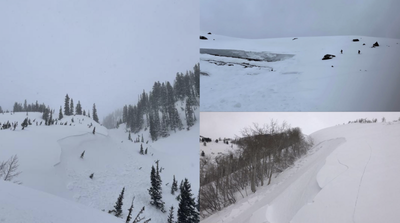
One person reported an avalanche from
Loafer Mountain south of the Provo Core. This avalanche was remotely triggered (from a distance on the ridge) and was 6 inches deep and 125 feet wide.
Yesterday in the Wasatch, avalanche activity revolved around the strong southerly winds blowing and drifting snow into dense slabs (wind slabs) that were mainly 10-20 inches deep and up to 125' wide. Out of the ten reported avalanches, the most impressive was from Days Fork and Broads Fork. In Days Fork, a cornice failed naturally and triggered a hard slab roughly 2-3 feet deep and 150 feet wide.
In Broads Fork, a natural glide avalanche failed roughly 10 feet deep and 125 feet wide, running to the valley bottom. This avalanche would have ruined anyone's day, and luckily it happened when no one was around. Be sure to read all the observations and recent avalanche activity
HERE. Photos: Starting left and going clockwise. Whitepine / Broads Fork / Loafer Mountain.