Forecast for the Provo Area Mountains

Dave Kelly
Issued by Dave Kelly for
Sunday, March 31, 2024
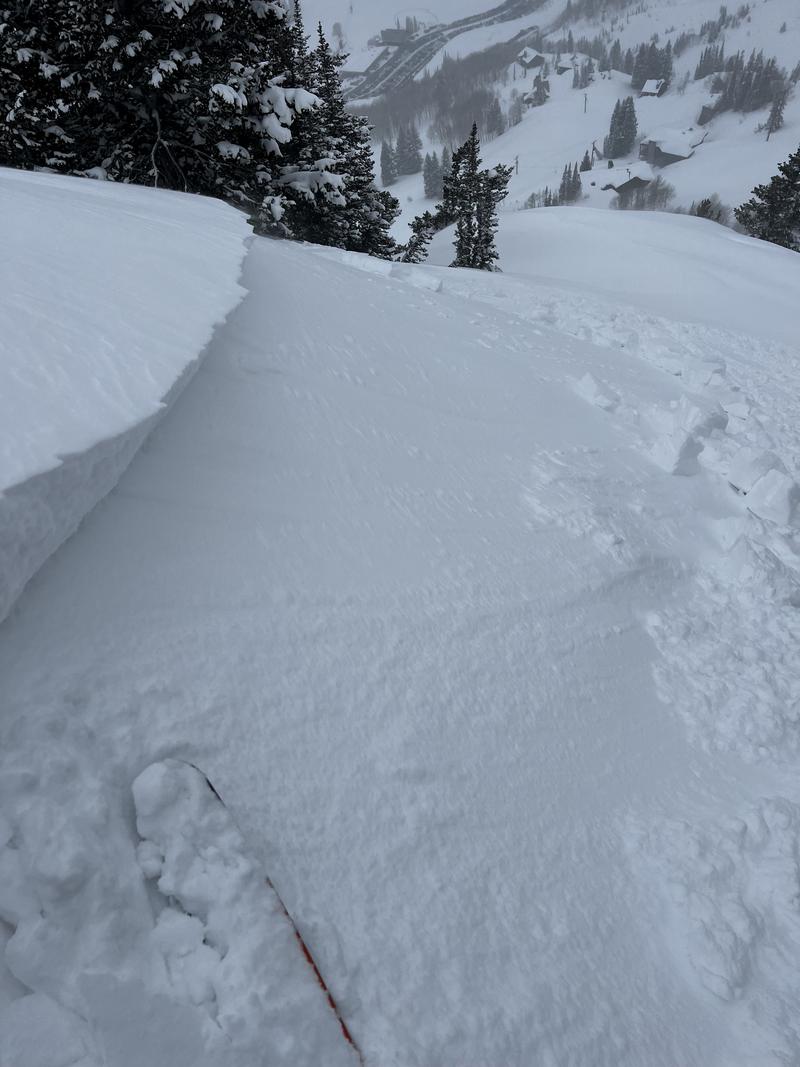
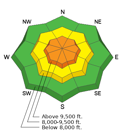
Today, the avalanche danger is CONSIDERABLE in upper elevation terrain where humans are likely to trigger wind-drifted snow avalanches. The avalanche danger is MODERATE in mid elevation terrain and LOW in lower elevation terrain where it will still be possible to trigger avalanches failing within new or wind-drifted snow.
Today, use careful snowpack evaluation and cautious route finding when you are near or approaching exposed ridge-tops or areas where strong winds have transported new snow. Avalanches travel in packs, so if you see signs of instability, it is time to back off and choose lower angle terrain.
Low
Moderate
Considerable
High
Extreme
Learn how to read the forecast here
Special Announcements
Support the UAC website backend platform to ensure the ongoing security of the website and the data stored on the site rebuild by donating to our spring campaign.
Weather and Snow
Currently, under overcast skies light snow is falling. We have had 2"-3" new snow with .20"-.40" water overnight, which brings the most recent storm totals to 3"-5" of snow and .30"-.60" water. Temperatures are in the low 30's °F. Winds at the 8,000' ridge-lines are blowing from the south-southwest in the mid 20's MPH gusting to the 40's MPH.
Today, skies will be overcast, temperatures should be 34-38°F, with winds blowing from the southwest 20 gusting to 25 MPH at the lower ridge-lines and 25 gusting to 35 MPH at the highest ridge-lines. Look for 4"-8" of snow with .40"-.75" of water. The freezing level will start around 7,000' and drop throughout the day. There is a 15% chance of lightning and any strong frontal passages could bring periods of increased precipitation.
Our partners at the National Weather Service have issued a Winter Weather Advisory from now until midnight on Sunday March 31st.
Recent Avalanches
Yesterday, there were no reports from the Provo Forecast Region. Just north of Provo in the Salt Lake Region backcountry travelers reported long running soft slab avalanches and ski resort operations reported sensitive wind-drifts near ridgetops. UAC Forecaster Greg found the common theme was that the new snow needed a bit of wind to give it the body to pack a bigger punch. There was a close call in 1,000 Turns Gully where one backcountry traveler was caught, carried, and lost gear; and another skier triggered slide with a great video in Silver Fork. People also reported wet snow below 9,000' with natural wet loose slides reported in mid-Little Cottonwood Canyon in the Y, Y-Not, and Triangle.

Photo of sensitive wind slab on north facing Patsy (G. Gagne).

Check out all avalanches and observations HERE.
Ad
Avalanche Problem #1
Wind Drifted Snow
Type
Location
Likelihood
Size
Description
Continued moderate to strong winds overnight have created sensitive soft slabs of wind-drifted snow at the mid and upper elevations. Today, wind-drifted snow avalanches will be stiffer than they were yesterday and may start to break above you. While this problem will be more prevalent at the upper elevations, exposed ridge-tops below 9,500' will still see areas of wind-drifted snow. Avalanches involving wind-drifted snow may be over 2' deep and up to 150' wide.

Sensitive cornices can be found along many exposed ridgelines at the mid and upper elevations. Avoid traveling on or below corniced ridgelines as a cornice collapse could trigger a new or wind-drifted snow avalanche.
Avalanche Problem #2
New Snow
Type
Location
Likelihood
Size
Description
Triggering an avalanche involving sluffing or soft slabs of new snow is possible on all steep slopes. Yesterday, there were reports of weak snow on mid-elevation northeast facing terrain that was made up of small grained facets now 8"-10" below the surface running on a melt-freeze crust. These north and east facing slopes are the places I would be cautious of especially in terrain over 35 ° in steepness. This is similar to what I found in Days Fork on Friday.
Now that we are towards the end of March if any sun comes out at all expect to see rapid heating of the snow surface and new dry loose avalanches quickly turning to wet loose avalanches. Avalanches that start as dry snow in the Provo Area Mountains can turn into wet avalanches very quickly and can overrun the snow line down below into places where people are not expecting to see avalanche debris. If you are traveling under run outs of avalanche paths during periods of increased precipitation you could be impacted by avalanches that run down to lower elevations.
Additional Information
In 2004, local avalanche researcher Ian McCammon wrote a pivotal paper discussing the Human Factors or how we contribute to the avalanche triangle. These FACETS are worth thinking about all the time, but I find them especially relevant as we head into springtime. Read the full article HERE.
Illustration: Mike Clelland
General Announcements
This information does not apply to developed ski areas or highways where avalanche control is normally done. This forecast is from the U.S.D.A. Forest Service, which is solely responsible for its content. This forecast describes general avalanche conditions and local variations always occur.