Donate to Our Spring Campaign or Bid on our Spring Auction to Support Forecasting

Forecast for the Provo Area Mountains

Drew Hardesty
Issued by Drew Hardesty on
Thursday morning, March 27, 2025
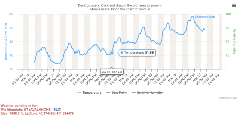
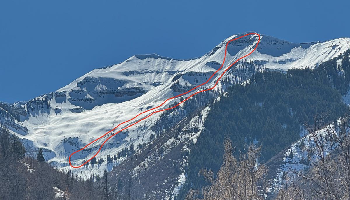
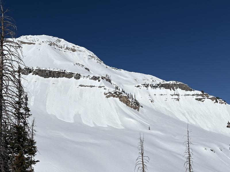
The avalanche danger will quickly rise to CONSIDERABLE on easterly to southerly to westerly facing slopes for destructive wet loose and wet slab avalanches. The danger for wet avalanches will also elevate to MODERATE on some northerly facing slopes at the mid and some upper elevations. CORNICES are a significant hazard. They may release naturally and trigger large avalanches below.
Travel Advice: It's a day to avoid steep, avalanche prone terrain, particularly by mid/late morning.
Low
Moderate
Considerable
High
Extreme
Learn how to read the forecast here
Special Announcements
Our Spring Campaign is in full swing, and there are two great ways to support forecasting, awareness, and education across Utah: Donate to our Spring Campaign, or Bid on items in our Spring Auction. Every dollar donated helps keep the backcountry community on top.
Weather and Snow
Skies are clear.
As of 5am, temperatures are again well above freezing with overnight "lows" in the upper 40s to mid-50s.!
Winds are from the southwest, blowing 15-20mph with gusts to 25. The most exposed anemometers are registering hourly averages of 30-40mph with gusts to 45.
Your window for supportable travel will be earlier and narrower than in previous days.
For today, we'll see increasing high and mid-level clouds by early afternoon. The southwesterly winds will only ramp up as the day wears on and we may see gusts to 60 or 70 by late evening. A little ripple in the flow brings a touch of precipitation overnight with an early rain/snow line up to 9500'. Shouldn't be more than a trace or two. Temps cool slightly for Friday with a quick little storm for Saturday afternoon that might bring 2-5" of winter. Next week looks somewhat active.
See a screen capture of the Mid-Mtn weather station at roughly 7500'. You can see that the last, best refreeze was the morning of March 23rd!
Recent Avalanches
The wet snow shed cycle has begun. Natural wet loose and wet slab avalanches continue to run in the blistering heat. Warm, non-refreezing nights are only compounding the problem. Cornices, too, are tender and a large cornice fall along the Cascade ridgeline triggered a large hard slab avalanche below that ran over 2000' down the slope in upper Bunnels Fork of the South Fork. This avalanche from Tuesday was on a steep east facing slope at nearly 11,000' was 3.5' deep and 200' wide failing on weak sugary facets near the ground. This path avalanched earlier this winter. (Cascade ridgeline report) pic 1
UAC and UDOT teams noted and intentionally triggered many wet loose avalanches with daytime heating. pic 2 SZ Wall
Trent buzzed around the north and west sides of Timp yesterday and found impressive slab avalanches from the past week. You can find them in the link below.
Ad
Avalanche Problem #1
Wet Snow
Type
Location
Likelihood
Size
Description
Natural and human triggered wet loose and some wet slab avalanches can be expected today and your window for safe travel on supportable crusts will be earlier and more narrow than the last couple of days.
A couple things of note:
  1. Wet loose avalanches on nearly all aspects and elevations. Mountain temperatures will be warmer than yesterday, with daytime highs at 10,000' likely reaching into the mid-40s. Some upper elevation (above 9500') north facing slopes may be susceptible to wet loose avalanches.
  2. Wet slab avalanches. Some areas have not had a proper deep freeze for a couple of nights and free water pooling at various structural interfaces tends to promote wet slab releases. These wet slabs may be more likely on easterly or westerly facing aspects at the low and especially mid-elevations and be 1-4' deep and perhaps 1-200'+ wide. Wet slabs are generally much more dangerous and destructive than wet loose.
  3. Cornices are becoming weak and tender and are big enough to trigger large avalanches below, particularly on slopes that have avalanched previously this season. These are generally mid and upper elevation northwest to east facing slopes.
  4. Roofs are shedding their winter loads. Please keep an eye on people, kids, animals underneath the roof lines.
General Announcements
This information does not apply to developed ski areas or highways where avalanche control is normally done. This forecast is from the U.S.D.A. Forest Service, which is solely responsible for its content. This forecast describes general avalanche conditions and local variations always occur.