Donate to Our Spring Campaign or Bid on our Spring Auction to Support Forecasting

Forecast for the Provo Area Mountains

Trent Meisenheimer
Issued by Trent Meisenheimer on
Thursday morning, March 20, 2025
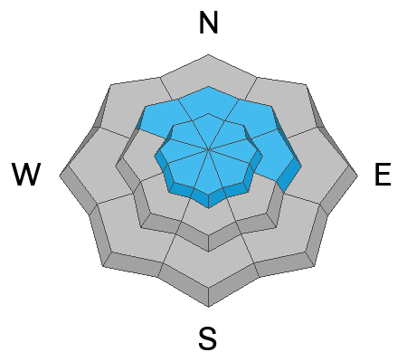
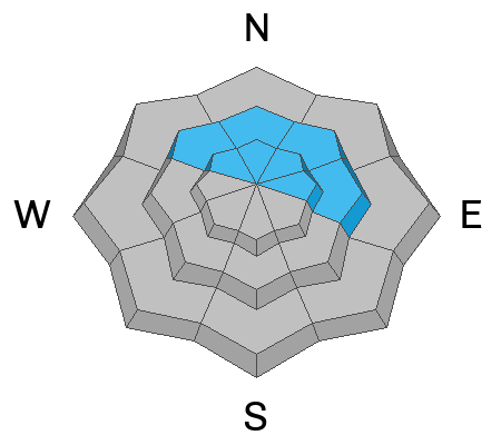
Areas of MODERATE avalanche danger exist on all upper-elevation slopes and on mid-elevation slopes facing northwest through east for wind-drifted snow avalanches. In either case, look for fresh soft or hard slabs of wind-drifted snow. Human-triggered avalanches 1 to 2 feet are possible. You will find an overall LOW avalanche danger out of the wind-affected terrain.
Hot tip: You can significantly reduce your risk of an avalanche today by avoiding the wind-loaded part of any slope. Slip in from below or the side and ensure there is no wind slab before committing to steep terrain.
Low
Moderate
Considerable
High
Extreme
Learn how to read the forecast here
Special Announcements
Our Spring Campaign is in full swing, and there are two great ways to support forecasting, awareness, and education across Utah: Donate to our Spring Campaign, or Bid on items in our Spring Auction. Every dollar donated helps keep the backcountry community on top.
Weather and Snow
Well, I hate to be the bearer of bad news, but the wind picked up last night around midnight and continues to blow from the southwest this morning at speeds of 10-15 mph gusts into the 30s. At 11,000', the wind is blowing from the southwest at 41 mph gusting to 68 mph. This wind will likely ruin the powder party in exposed terrain. Current mountain temperatures range from 24-28 °F.
Today, a minor cold front will push into Northern Utah, bringing increasing clouds and a chance for a couple of inches of new snow. Unfortunately, the pre-frontal southerly wind will continue to be the issue this morning until midday, when the wind will veer to the west and eventually the northwest and slow in speed. Mountain temperatures will rise into the upper 20s to low 30s °F.
The recent storm left roughly 5 to 10 inches of new snow in the Provo Range. Today, you will find good riding and turning conditions on most slopes with a northerly tilt to them. On slopes facing south and at low elevations, you will find a crust from yesterday's sun and warming temperatures.
Recent Avalanches
Yesterday, one observer noted two wind-drifted snow avalanches on the north end of Timpanogos that likely happened naturally at the tail end of the storm. One was a hard wind slab that was large enough to bury a human.
Ad
Avalanche Problem #1
Wind Drifted Snow
Type
Location
Likelihood
Size
Description
Pre-frontal southerly wind has created a fresh batch of wind-drifted snow. These drifts (soft or hard) could be 1-3 feet deep and large enough to catch and carry humans. Soft wind slabs are often pillowy and rounded-looking, while hard wind slabs sound hollow before they break around you. Be on the lookout and avoid slopes loaded by the wind.
Avalanche Problem #2
Persistent Weak Layer
Type
Location
Likelihood
Size
Description
We've been concerned about two weak layers buried in the snowpack for some time. The first layer is essentially basal depth hoar on slopes that have avalanched a time or two earlier this winter. The second is a layer of faceted snow adjacent to a dust layer 2-3 feet deep.
This last storm was another significant load on the snowpack, and plenty of people tested steep terrain yesterday. We heard no news of avalanches being triggered on either of these layers. Because of this, we are considering these layers dormant, and we will likely remove this problem from the forecast tomorrow.
General Announcements
This information does not apply to developed ski areas or highways where avalanche control is normally done. This forecast is from the U.S.D.A. Forest Service, which is solely responsible for its content. This forecast describes general avalanche conditions and local variations always occur.