UDOT PLANNED AVALANCHE CLOSURES!!

Forecast for the Provo Area Mountains

Mark Staples
Issued by Mark Staples for
Thursday, March 2, 2023
The avalanche danger today is MODERATE which means human-triggered avalanches are possible.

Since the middle of last week, 4-7 feet of snow has fallen. While the snowpack is stabilizing, that is simply a lot of snow. Wind-loaded slopes could have double that amount and could make a very large avalanche.
Low
Moderate
Considerable
High
Extreme
Learn how to read the forecast here
Special Announcements
To help you safely enjoy the backcountry, the UAC team is constantly evaluating and implementing new programs and technologies. Donate to the Spring Campaign to help our team implement innovative tools and better provide you with the information you rely on.
Weather and Snow
Yesterday 4-7 inches of snow fell with generally light winds.
This morning, temperatures range from 12-17°F and winds from the WNW are only blowing 12 mph at 11,000 ft. That's about as calm as it gets!
Today will have some mix of sun and clouds. Temperatures should warm into mid 20s F at upper elevations and be near or above 30°F at low elevations. Winds will generally remain light. Cold air will remain over the area but the sun is quite strong this time of year and will make it feel a bit warmer.
Total snowfall since last week is impressive
  • Upper Cottonwoods 68-79" snow (5.1-5.8" water)
  • Park City Ridgeline 54-60" snow (3.6" water)
  • Ogden area mountains 64-73" snow (5.8-6.6" water)
  • Provo area mountains 59-82" snow (5.3-6.8" water)

Looking ahead - Tonight and into Friday will have a quick-moving storm that will bring 3-6 inches of snow. More snow and strong SW winds arrive later on Saturday into Sunday. There is a lot of uncertainty with snowfall during that time. Temperatures overall appear to remain cool as the jet stream will be to our south.
Recent Avalanches
There wasn't much avalanche activity reported yesterday. Some of the biggest slides were triggered by UDOT in Little Cottonwood Canyon. There was also some natural activity reported yesterday involving shallow soft slabs of new snow during a brief period of high snowfall rates.
Ad
Avalanche Problem #1
Wind Drifted Snow
Type
Location
Likelihood
Size
Description
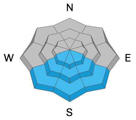
Even though the likelihood of triggering a slab avalanche of wind drifted snow is going down, I wouldn't take my chances with this problem. There has been so much snow and wind over the last week, that these avalanches have the potential to be be very big as seen in the slide triggered by UDOT in the video above. Winds have blown from both the NW and SW
With almost 7 feet of snow (almost 7" of water) falling in the last week, heavily wind-loaded slopes could have double or triple that amount (14" of water or more). Winds have been mostly light the last 24 hours, and these wind loaded starting zones should have fluffy snow on the surface, but know that there is a massive hard slab underneath.
Avalanche Problem #2
New Snow
Type
Location
Likelihood
Size
Description
I doubt you will seen any signs of instability in the new snow, BUT there is simply a TON of new snow...even at low elevations (see note below under Additional Info). It's still possible that one of the storm layers isn't fully bonded, and you could trigger a soft slab avalanche in the new snow.
For today, I'd stack the odds in my favor and choose terrain with less severe consequences in case you happen to trigger a slide. This means choosing slopes with a runout free from trees, rocks, gullies, or other features that would either cause a deeper burial or trauma.
Avalanche Problem #3
Wet Snow
Type
Location
Likelihood
Size
Description
If you're like me, it's hard to have a sense of how strong the sun is because we haven't seen much of it this winter, but it can be intense this time of year.
Snow on south facing slopes should become wet today, but I'm unsure how wet it will get. If there are few clouds, the strong sun could cause some wet loose avalanches espeically around areas with exposed rocks. If a few more clouds provide some shade, then the snow will just get wet without any avalanches.
Additional Information
The lowest elevation band has some tricky conditions as we've seen avalanches in the foothills as low as 6,200'. There is more than enough snow in the lower elevation foothills that there is good riding to be had close to home. These three avalanches stand out in that they all occurred in low elevation easy to access terrain that you can see from highways and neighborhoods. Check out Craig's video discussing a low elevation avalanche in Browns Canyon HERE, Drew's video discussing an avalanche in the Salt Lake Foothills HERE, and JB's report from the Ogden Foothills HERE. These are the types of slides that can impact people with little knowledge of avalanche terrain. Please share this information with your friends who may not regularly read the avalanche report.
General Announcements
This information does not apply to developed ski areas or highways where avalanche control is normally done. This forecast is from the U.S.D.A. Forest Service, which is solely responsible for its content. This forecast describes general avalanche conditions and local variations always occur.