Forecast for the Provo Area Mountains

Dave Kelly
Issued by Dave Kelly for
Sunday, March 17, 2024
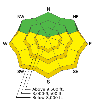
The avalanche danger will rise to MODERATE at all elevations facing east-south-west, where it will be possible for humans to trigger wet loose snow avalanches that could lead to shallow wet slab avalanches on steep solar aspects. All other aspects have a LOW avalanche danger.
Dealing with a wet-snow problem is a matter of timing and avoiding being on damp surfaces during the warmest part of the day is the best approach.
Low
Moderate
Considerable
High
Extreme
Learn how to read the forecast here
Special Announcements
Support the UAC website rebuild by donating to our Spring Campaign.
The Utah Avalanche Center is hosting The Banff Film Festival on Thursday, March 21, and Friday, March 22 in Moab.
Weather and Snow
Currently, under high clouds temperatures are in the high 20's °F. Winds are blowing from the north-east in the mid-teens gusting to the 20's MPH at the 8,000' ridge-lines. Downslope winds continue to blow at the mouths of the canyons and exposed areas could see increased wind speeds throughout the day.
Today, expect thin clouds transitioning to sunny skies. Temperatures will be 44-49 °F with a freezing level from 7,000'-8,000'. Winds will blow from the east 15 gusting to 20 MPH at the 9,000' ridge-lines and 15 gusting to 25 MPH at the 11,000' ridge-lines. No new snow is expected today. Unsettled stormy weather returns later next week. Read more from our partners at the National Weather Service HERE.

The snow surface in many locations is tired and made-up of wind-affected surfaces, firm melt-freeze crust or damp snow depending on the time of day. Protected north facing terrain is still sheltering a soft snow surface.
Recent Avalanches
Yesterday, there was skier involved in a wet-loose avalanche in the Aspen Grove Area. This was on an east facing slope at 8,400' and occurred around noon.

Check out all recent Observations HERE.
Ad
Avalanche Problem #1
Wet Snow
Type
Location
Likelihood
Size
Description
Expect to see wet loose avalanche activity on solar aspects with daytime warming. This will be most evident in areas out of the wind zone and in steep rocky gully features. The best way to avoid this problem is to be off of sunny slopes before they start to take too much heat.
Roller balls, dripping water off of rocks, and your boots or skis sinking into the surface snow are signs it's time to move to higher elevation terrain. This wet snow problem is most pronounced on steep terrain facing east-south-west but not to be discounted in lower elevation north facing terrain.
Wet slides also have the potential to run further than expected and can impact backcountry travelers that are below avalanche terrain.
Avalanche Problem #2
Wind Drifted Snow
Type
Location
Likelihood
Size
Description
There will be isolated areas where you may find soft slabs of wind-drifted snow 1'-3' deep. These will be most pronounced on leeward-facing slopes; but sporadic winds have loaded many aspects and elevations and I wouldn't discount finding an area of wind-drifted snow in mid-elevation terrain.
Look for and avoid signs of wind-drifted snow such as texture and pillow-shaped features. Approach steep terrain features that have accumulated drifting snow cautiously.
Limit your exposure to ridgelines near cornices and slopes below them. A cornice fall could trigger a slab of wind-drifted snow.
Wind-drifting snow and mixed snow surface on a ridge-line on the eastern side of Timp (Photo: Coyne)
Additional Information
Check out Drew Hardesty's blog on traveling during LOW danger HERE.
General Announcements
This information does not apply to developed ski areas or highways where avalanche control is normally done. This forecast is from the U.S.D.A. Forest Service, which is solely responsible for its content. This forecast describes general avalanche conditions and local variations always occur.