Donate to Our Spring Campaign or Bid on our Spring Auction to Support Forecasting

Forecast for the Provo Area Mountains

Dave Kelly
Issued by Dave Kelly on
Sunday morning, March 16, 2025
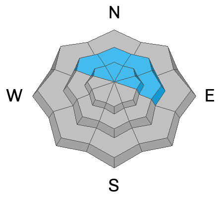
There is a CONSIDERABLE avalanche danger in upper-elevation terrain where humans are likely to trigger a new or wind-drifted snow avalanche that could be up to 2' deep and 150' wide and at mid and low elevation southerly facing terrain where natural wet avalanches are likely with daytime warming. The avalanche danger is MODERATE on all other aspects and elevations.
The catch today will be whether the warm March sun or the wind has more effect on the snow surface. Prepare to adapt your tour plan based on your observations and be on the lookout for and avoid wind-drifted snow problems at higher elevations and wet snow at mid and low elevations.
Low
Moderate
Considerable
High
Extreme
Learn how to read the forecast here
Special Announcements
Our Spring Campaign is in full swing, and there are two great ways to support forecasting, awareness, and education across Utah: Donate to our Spring Campaign, or Bid on items in our Spring Auction. Every dollar donated helps keep the backcountry community on top.
Weather and Snow
Currently, under partly cloudy skies temperatures are in the mid 20's °F. Winds are blowing from the south in the 20's gusting to the 30's MPH at the exposed ridgelines. We have had 1" to 3" of snow in the last 24-hours which brings storm totals to 15"-18" of snow and 1.25"-2" of water weight.
Today, look for partly cloudy skies with light snow possible. Temperatures will rise to the mid 40's °F. Winds will blow from the southwest at the lower ridgelines 20 gusting to 30 MPH and at the highest peaks 40 gusting to 55 MPH and increasing in speed later this afternoon with gusts into the 60's MPH.

This time of year, the catch is to get the new snow before the sun does regardless of air temperatures.
Recent Avalanches
Yesterday, there were no reports from the Provo Area Forecast Region.

Check out all recent avalanches and observations HERE.
Ad
Avalanche Problem #1
Wind Drifted Snow
Type
Location
Likelihood
Size
Description
There is new snow at all elevations that is primed for transport. With increased wind speeds at the mid and upper elevations today you may see drifting snow lower on the slope than you expect. Keep an eye out for cracking, collapsing, new cornice buildup or pillowy wind loaded features. If you see these signs then avoid traveling on or underneath slopes with wind-drifted snow.
Avalanche Problem #2
Wet Snow
Type
Location
Likelihood
Size
Description
New snow combined with warm March sun and longer days mean higher likelihood of seeing natural wet avalanches in the Provo Region. These could start as dry snow avalanches and very quickly turn wet as they move down slope. The best way to avoid these avalanches is to stay away from and out from underneath slopes that have been warmed by the sun. This problem will start on the southerlies in the late morning/early afternoon and move to west facing slope in the later afternoon hours. Avoiding damp slopes is your best bet. You may also see wet loose avalanches in lower elevation northerly facing terrain.
Avalanche Problem #3
Persistent Weak Layer
Type
Location
Likelihood
Size
Description
The chance of triggering an avalanche failing on a deeper buried layer of facets near the ground is diminishing with time. The first layer of facets now buried near the ground is most likely to be triggered in thinner spots on northwest-north-east facing mid and upper-elevation aspects. The second persistent weak layer (PWL) is a thin dust layer that formed and was buried in early March and is now buried 2'-3' deep. This dusty layer will be easy to identify and recent test results have showed propagation becoming more difficult on this layer.
This most recent storm is a great test of both of these layers and while I don't trust that these layers are gone, I think that we're starting to turn the corner on this season of persistent weak layers.
General Announcements
This information does not apply to developed ski areas or highways where avalanche control is normally done. This forecast is from the U.S.D.A. Forest Service, which is solely responsible for its content. This forecast describes general avalanche conditions and local variations always occur.