Donate to Our Spring Campaign or Bid on our Spring Auction to Support Forecasting

Forecast for the Provo Area Mountains

Nikki Champion
Issued by Nikki Champion on
Monday morning, March 17, 2025
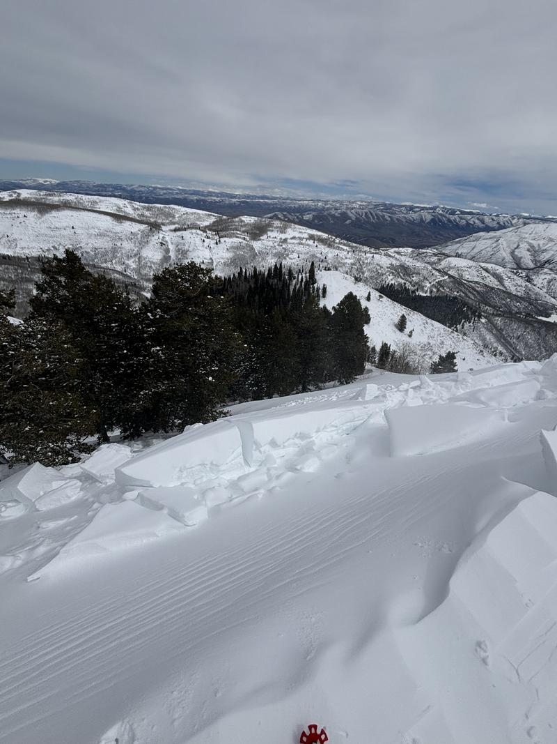
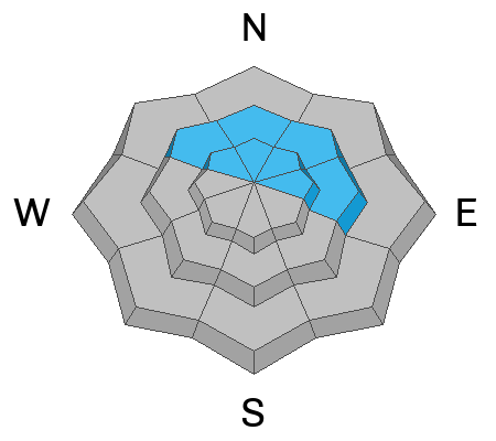
There is CONSIDERABLE avalanche danger in upper-elevation terrain, where strong winds and soft snow have created dangerous conditions. Human-triggered avalanches are likely in these areas, potentially up to 2 feet deep and over 150 feet wide.
The avalanche danger could also rise to CONSIDERABLE throughout the day in low and mid-elevation southerly-facing terrain, where natural wet avalanches are likely due to daytime warming and strong March sun. The avalanche danger is MODERATE on all other aspects and elevations.
Be prepared to adjust your tour plan based on your observations. Watch for wind-drifted snow at higher elevations and wet snow at mid and lower elevations. Limit exposure by having one person at a time on steep slopes (greater than 30°) and always be mindful of those below you. Careful snowpack evaluation, cautious route-finding, and conservative decision-making will be critical today.
Low
Moderate
Considerable
High
Extreme
Learn how to read the forecast here
Special Announcements
Our Spring Campaign is in full swing, and there are two great ways to support forecasting, awareness, and education across Utah: Donate to our Spring Campaign, or Bid on items in our Spring Auction. Every dollar donated helps keep the backcountry community on top.
Weather and Snow
This morning, skies are partly cloudy, with temperatures already climbing into the mid 30s to low 40s°F. Winds are coming from the southwest at 15-25 MPH, gusting into the 40s at lower ridgelines, and 25-40 MPH, gusting into the 60s at higher ridgelines.
Today, skies will be partly sunny, and temperatures will rise into the mid and upper 40s°F. Winds will continue from the southwest, blowing 25-35 MPH with gusts up to 45 MPH at lower ridgelines, and 20-35 MPH gusting to 65 MPH at the highest peaks. Winds will remain elevated throughout the day, peaking early in the evening ahead of the incoming cold front.
A storm system will push a strong cold front into the area, bringing periods of moderate to heavy snow near and behind the front. Total storm snowfall is expected to range from 5-10 inches, with 0.45-0.95 inches of water from March 17 to March 19.
This time of year, the key is to get the new snow before the sun does, regardless of air temperatures.
Recent Avalanches
Yesterday, multiple reports highlighted widespread soft slabs of wind-drifted snow failing on density changes across the Provo area backcountry. There was significant drifting snow and obvious transport throughout the day, with cracking observed along ridgelines. A 2-foot soft slab avalanche was triggered by a snowmobiler in Snake Creek (Provo), and a 10-inch soft slab was triggered by a skier in the UFO Bowls (Provo), with both avalanches reaching widths of up to 175–200 feet.Ski resorts also reported sensitive wind slabs at upper-elevation ridgelines.
Wind slab triggered along the UFO Bowl approach - SE Aspect - 9700' - S. Nelson

Check out all recent avalanches and observations HERE.
Ad
Avalanche Problem #1
Wind Drifted Snow
Type
Location
Likelihood
Size
Description
Winds have increased since yesterday, with gusts reaching 80 mph on upper ridgelines and expected to remain strong throughout the day.
With abundant soft snow for transport, these winds are rapidly building both soft and hard wind slabs. Expect these slabs to grow larger and more cohesive as the day progresses. While most noticeable on leeward north to east slopes, high winds can load any aspect and drift snow farther downslope than anticipated.
Use caution in steep terrain where drifting snow has accumulated. Watch for signs of instability such as cracking, collapsing, new cornice growth, or pillowy features. If you spot any of these, avoid traveling on or beneath wind-loaded slopes. Cornices are growing larger and are more likely to fail during high winds or warming temperatures—give them a wide berth.
Avalanche Problem #2
Wet Snow
Type
Location
Likelihood
Size
Description
The March sun is strong, and regardless of air temperatures or wind speeds, we could see wet loose avalanches, roof slides, and a gloppy snow surfaces.
New snow, combined with warm March sun and longer days, increases the likelihood of natural wet avalanches in the Provo Region. These avalanches may start as dry snow but quickly turn wet as they move downslope. Timing is key—get off steep, sunlit slopes as they warm. This problem will begin on southerly slopes in the late morning/early afternoon and shift to west-facing slopes in the afternoon. Avoid damp slopes where possible. Wet loose avalanches may also be seen on lower-elevation, north-facing terrain.
These avalanches can impact more than just your group, so always be aware of others traveling below or above you.
Avalanche Problem #3
Persistent Weak Layer
Type
Location
Likelihood
Size
Description
The likelihood of triggering an avalanche on the deeply buried facets near the ground continues to decrease but remains a concern in thinner spots on northwest through northeast-facing slopes at mid and upper elevations.
A second persistent weak layer, a thin dust layer buried in early March, now sits 2 to 3 feet deep. While easy to identify, recent tests show propagation is becoming more difficult.
These layers are most concerning in areas with any additional wind loading, where the risk of a deeper avalanche stepping down into a weak layer is highest.
This storm has been a key test for both weak layers. While I wouldn’t call them dormant yet, we seem to be turning the corner on this season’s persistent weak layer problem.
General Announcements
This information does not apply to developed ski areas or highways where avalanche control is normally done. This forecast is from the U.S.D.A. Forest Service, which is solely responsible for its content. This forecast describes general avalanche conditions and local variations always occur.