Donate to Our Spring Campaign or Bid on our Spring Auction to Support Forecasting

Forecast for the Provo Area Mountains

Drew Hardesty
Issued by Drew Hardesty on
Tuesday morning, March 18, 2025
A MODERATE avalanche danger exists on all steep slopes with recent deposits of wind drifted snow. These old and new drifts are more pronounced on steep north to east to south facing terrain of the mid and upper elevations. Loose snow avalanches can be expected in the steepest terrain. Evaluate snow and terrain carefully today.
Low
Moderate
Considerable
High
Extreme
Learn how to read the forecast here
Special Announcements
Our Spring Campaign is in full swing, and there are two great ways to support forecasting, awareness, and education across Utah: Donate to our Spring Campaign, or Bid on items in our Spring Auction. Every dollar donated helps keep the backcountry community on top.
Weather and Snow
The storm is upon us as foretold with 4-6" reported as of 6am.
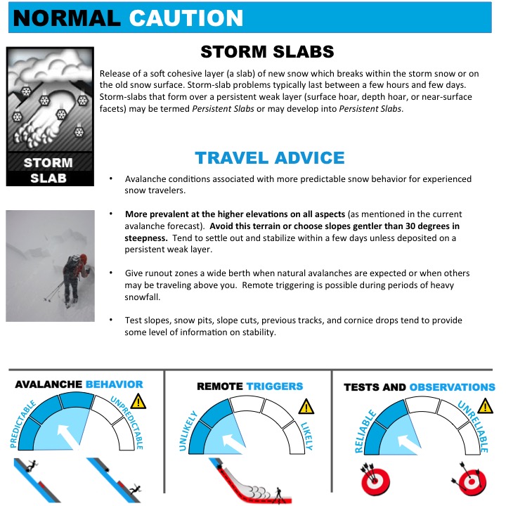
Frontal passage occurred around midnight with a dramatic drop in temperatures and a wind shift to the northwest. Mountain temperatures are in the mid-20s. The searing southwesterly winds, mercifully, are a thing of the past, having lost steam after veering to the northwest. They're averaging 10-15mph with gusts to 20. Along the highest ridgelines, they're seeing hourly averages of 25-30mph with gusts to 35.

Today: It should snow off and on today with 5-10" possible by dinnertime. Temperatures will drop toward the single digits to upper teens. The spoiler: I'm seeing moderate to occasionally strong west to northwest winds along the ridgelines today. I hope I'm wrong, but it might be worth planning your outing today for wind sheltered terrain. Let me know how it goes.
The Outlook: some clearing for Wednesday with some unsettled weather for Thursday and perhaps Saturday.
Recent Avalanches
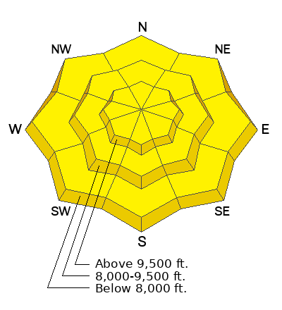
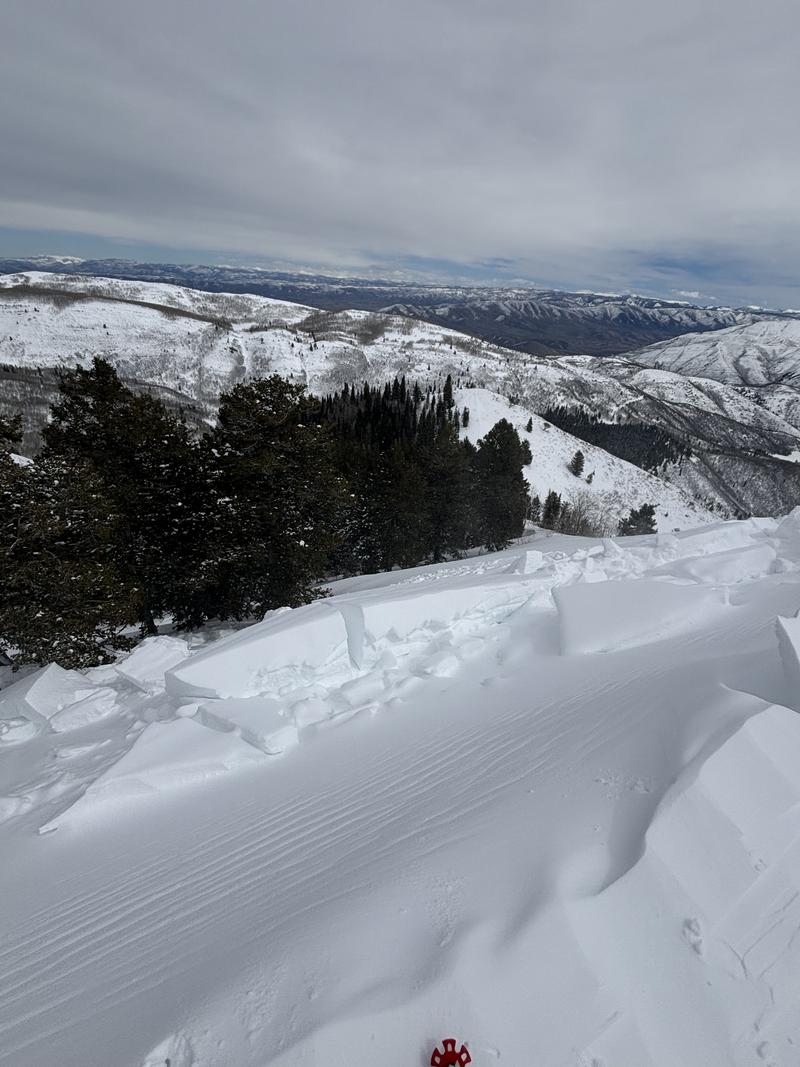
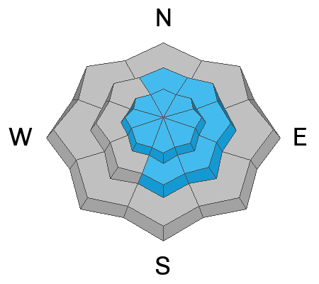
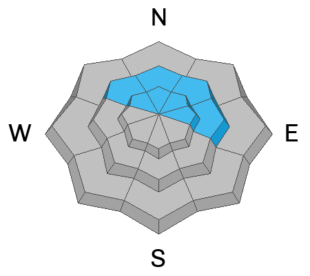
The most recent reported avalanches were fresh wind slabs noted on Sunday (Nelson pic in UFO Bowls). The searing southwesterly winds loaded many northerly facing slopes at the mid and upper elevations. The warmth and time have stabilized most (but not all) of these recent wind slabs.

It's not in our forecast zone, per se, but many Wasatch skiers and riders head to the Ruby Range just south of Elko, Nevada. Often the prize they're seeking is the Terminal Cancer couloir in Lamoille Canyon. Some local skiers had a very close call on Sunday and sent us an excellent write-up that offers some good takeaways. Recommended reading.
Ad
Avalanche Problem #1
Wind Drifted Snow
Type
Location
Likelihood
Size
Description
IF the winds verify, we'll see some sensitive soft slabs of wind drifted snow primarily on north to east to south facing terrain of the upper elevations...and scattered across the compass at the mid-elevations. Most of the wind slabs from the recent days and days of strong southwest winds have probably stabilized....but not all, particularly at the higher elevations. These older wind slabs are hard and stubborn and hold their cards close (ie-no cracking or collapsing), but the newest drifts will not be as coy - test slopes and ski cuts should provide the info you need. Please keep cornices on your radar - they loom large these days. Don't wander out on top of them in the whiteout.
Trend: Increasing danger
Uncertainty Level: Moderate
Avalanche Problem #2
New Snow
Type
Location
Likelihood
Size
Description
The new snow should bond fairly well to the old warm and worn snow surfaces, but with heavy snowfall, failure planes may occur within the storm snow. Natural storm slab and loose snow avalanches occur during peak snowfall instability and springtime can offer just that. You don't want to find yourself in the steepest terrain with nowhere to hide when it starts to snow 2"/hour. To be clear: booting up steep couloirs during the storm is not recommended today.
Trend: Increasing Danger
Uncertainty Level: Low
Avalanche Problem #3
Persistent Weak Layer
Type
Location
Likelihood
Size
Description
The likelihood of triggering an avalanche on one of two buried persistent weak layers is low, but still worth a mention, particularly during heavy snowfall and wind. The two layers of concern are essentially basal depth hoar on slopes that have avalanched a time or two earlier this winter. The second is a layer of faceted snow adjacent to a dust layer 2-3 feet deep. These might be more susceptible to releasing by cornice fall or by a more superficial avalanche that then steps down.
General Announcements
This information does not apply to developed ski areas or highways where avalanche control is normally done. This forecast is from the U.S.D.A. Forest Service, which is solely responsible for its content. This forecast describes general avalanche conditions and local variations always occur.