Donate to the 2024 Spring Campaign to help rebuild the UAC website.

Forecast for the Provo Area Mountains

Nikki Champion
Issued by Nikki Champion for
Friday, March 10, 2023
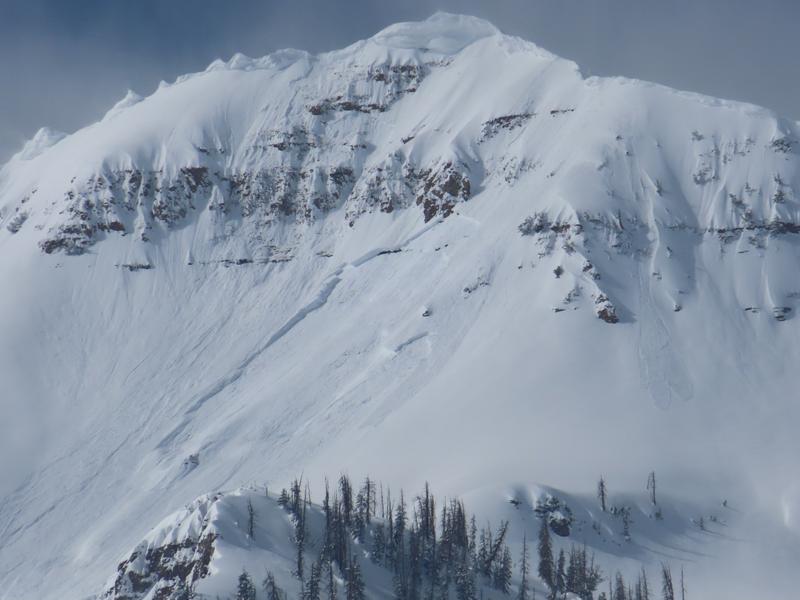
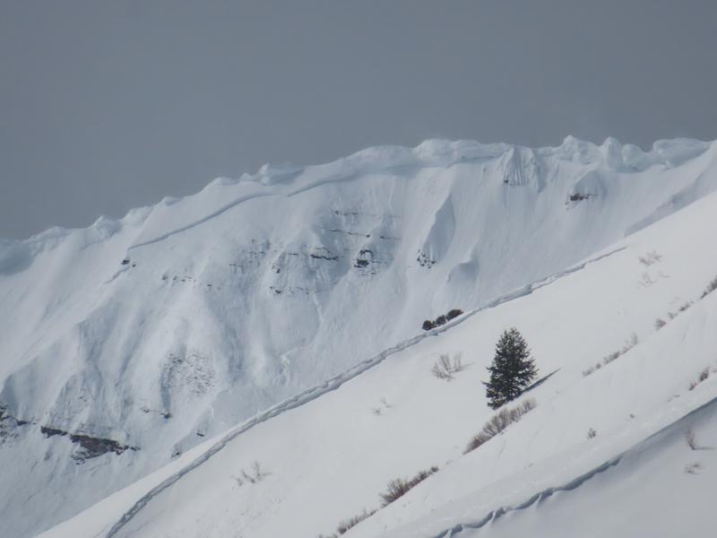
Heavy snowfall, high winds, and warm temperatures will cause the avalanche danger to rise to CONSIDERABLE on all aspects and all elevations. The high winds will continue to create unstable slabs of wind-drifted snow at all mid and upper elevations. Both loose snow and slab avalanches may be possible within layers of new snow from the last two weeks. Dangerous avalanche conditions exist in the backcountry today.
Pay attention to the rain line at mid and lower elevations. If we see sustainable rain on snow we may begin to see wet activity within the saturated snowpack. If the snow surface has become wet and unconsolidated, it is time to move off of and out from underneath any steep slopes at that elevation band.
Low
Moderate
Considerable
High
Extreme
Learn how to read the forecast here
Special Announcements
The UAC is sad to report that two skiers were caught and buried in a large avalanche in Upper Weber Canyon in the Uintas yesterday. One skier was successfully rescued and survived. Sadly, the other skier was buried deeper and did not survive. A preliminary report is available HERE.
Please consider donating to the spring campaign to help our team implement innovative tools and better provide you with the information you rely on.
Weather and Snow
This morning, the skies are overcast with light snowfall. The overnight snow totals are up to 4". Mountain temperatures rose overnight and are sitting in the upper 20s and low 30s F this morning. Winds have really picked up, averaging 25-35 from the southwest with gusts up to 65 mph.
Today, the atmospheric river event we keep talking will bring rising snow levels, warm temperatures, and high winds. Snowfall should continue, becoming heavy at times. 3-8" of new snow could fall before 5 PM. The majority of the precipitation to occur this afternoon, when the snow/rain line hovers around 8,000' and could become heavy rainfall at times. Temperatures will climb into the upper 30s and low 40s F. Winds will remain south, southwesterly. At the mid-elevation ridgelines, winds will average 25-35 mph, with gusts up to 55 mph. At the 11,000' ridgelines winds will gust up to 80 mph.
Outlook, overnight the snowfall will remain heavy, beginning to decrease after midnight. Temperatures will begin to drop into the evening, but winds will remain elevated with gusts up to 105 mph. The overall snow totals by the 12th could be between 12-22" of new snow (1.75-3.20" of water).

Total snow depths are 11-15' in the upper Cottonwoods, 7-10' along the Park City ridgeline, 8-11' in the Ogden area mountains where up to 7' is at some low elevation locations, and 8-10' in the Provo area mountains. Most trailheads have 4' of snow.
Recent Avalanches
Yesterday, there were reports of wind-drifted snow avalanches, natural cornice fall, and wet-loose activity in the backcountry.
Photos of Cascade Ridge wind slab (photos: UDOT Provo)
Ad
Avalanche Problem #1
Wind Drifted Snow
Type
Location
Likelihood
Size
Description
The huge bump in overnight winds plus soft snow available for transport will have formed both shallow soft slabs of wind-drifted snow at all mid and upper elevations. With the winds slated to remain elevated, these shallow slabs will only continue to grow, and become more cohesive throughout the day. These slabs will be most pronounced on lee-ward facing slopes, but such high winds can load any aspect because winds swirl and change direction as they pass through the mountains, this is known as cross-loading.
Look for slopes with any signs of wind-drifted snow, such as cracking, hollow noises, and pillow-shaped snow, and avoid those slopes.
Cornices: Yesterday we got more reports of natural cornice fall. Cornices are currently large and only continue to grow in the backcountry. With this warm storm and high winds, we will continue to see more cornices breaking naturally. Give cornices, and the edges of cornices a wide berth as they often break farther back than expected. Limit your exposure to slopes below cornices. A cornice fall could trigger a larger slab of wind-drifted snow below.
Avalanche Problem #2
New Snow
Type
Location
Likelihood
Size
Description
Today both slab and loose snow avalanches may break 1-3 feet deep within layers of new snow from today's storm, and the last two weeks of new snow. All things considered, we have a pretty solid snowpack in the backcountry, but with continuous storms, buried ice crusts, buried rime crusts, softer layers of snow, and very isolated pockets of some facets, conditions remain a bit complicated.
The main takeaway is we have a lot of snow, and as we add more stressors in the form of wind, snow, and potentially rain we are going to see new snow avalanches, and these avalanches could break directly on the new snow old snow interface or somewhere deeper within the snowpack on weaker snow or crusts.
Today, the type of avalanche, loose versus slab avalanche, will come down to how quickly the new snow bonds, versus how quickly the snow is falling from the sky. Watch for signs of instability such as cracking and sluffing.

RAIN ON SNOW: At the lower elevations, below 8,000, there is a chance we could see rain on snow. If we see sustainable rain on snow we may begin to see wet activity within the saturated snowpack. The main concern is having a naturally triggered slide come down onto you, especially if you are in a gully, couloir, or other confined terrain where avalanche debris can pile up deeper and you have no route for escape.
Timing is key, if you notice that the snow surface has become wet and unconsolidated, it is time to move off of and out from underneath any steep slopes at that elevation band.
Additional Information
While not directly avalanche problems, tree wells, "snow immersion suffocation" and roof avalanches are backcountry dangers worth noting this season with so much snowfall.
With so much snow on rooftops in mountain communities, roof avalanches will be a significant hazard with more snow, warmer temperatures, and the potential for heavy rain. Children are especially vulnerable to this hazard, but both adults and children have been killed by roof avalanches.
General Announcements
This information does not apply to developed ski areas or highways where avalanche control is normally done. This forecast is from the U.S.D.A. Forest Service, which is solely responsible for its content. This forecast describes general avalanche conditions and local variations always occur.