Forecast for the Provo Area Mountains

Trent Meisenheimer
Issued by Trent Meisenheimer for
Wednesday, February 7, 2024
UPDATE 1:36 PM: The UAC has issued an AVALANCHE WARNING. Avalanches are happening now. Strong winds and heavy snowfall have overloaded the mountains. The avalanche danger has reached HIGH danger and traveling in avalanche terrain is NOT recommended.
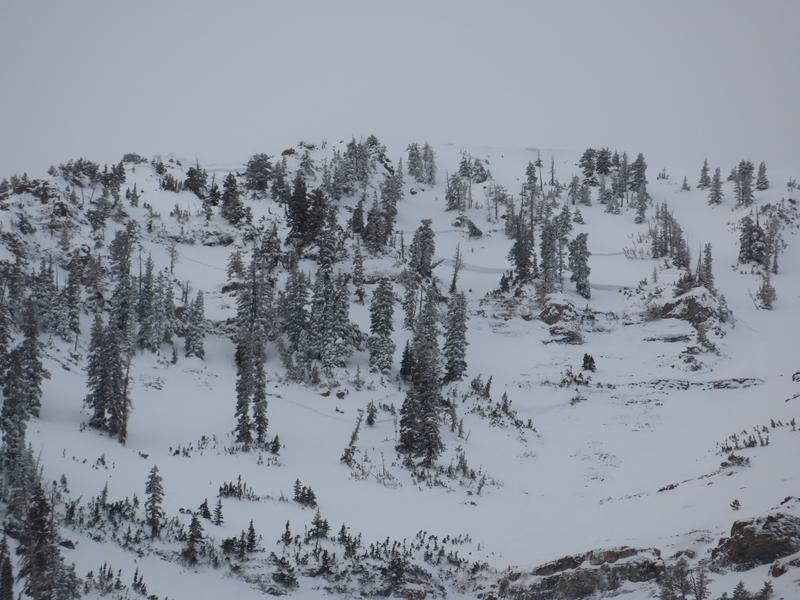
The avalanche danger is CONSIDERABLE across the mid and upper elevations for several avalanche problems. Pick your poison: Hard and soft slabs of wind-drifted snow. Soft slabs of new snow. Or you could trigger an avalanche that fails on a buried persistent weak layer. It's complicated and very dangerous.
In any case, the avalanche you trigger is likely a few hundred feet wide and could be 3 to 6 feet deep.
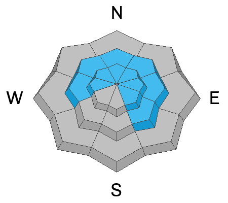
Low
Moderate
Considerable
High
Extreme
Learn how to read the forecast here
Weather and Snow
Another 2.0-8.0 inches of new snow fell in the past 24 hours, containing 0.29-1.05 water. This morning, it's snowing, and the southerly winds continue their onslaught, blowing 10-20 mph with gusts into the 20s and 30s. Mountain temperatures range from 25-31 °F.
Today, we should see continued snowfall throughout the morning on a southerly flow with winds blowing 10-20 mph. By this afternoon, the wind will finally change direction, blowing from the west and then the northwest. Once the wind changes, the snowfall is expected to be heavy at times. Throughout the day today, we could see an additional 7-17 inches of new snow (0.45-1.2 inches of water)
Recent Avalanches
In Provo, two large persistent weak-layer avalanches were reported from Elk Point. Both avalanches failed on weak faceted snow and were 3-4 feet deep, 400-600 feet wide, and ran 3,000 feet downhill (pic below). Across the lower elevations, damp, wet, and heavy snow produced widespread roller balls and wet-loose avalanches.
Yesterday's avalanche that caught my eye was a remotely triggered avalanche from a piece of terrain in upper Little Cottonwood on Sugarloaf Peak that represents a backcountry snowpack. Two patrollers were heading out to run routes and got the slope to collapse. The avalanche was 2 feet deep and 300 feet wide, failing on faceted snow (picture below).
Ad
Avalanche Problem #1
Wind Drifted Snow
Type
Location
Likelihood
Size
Description
It's been 60 straight hours of south winds blowing 10-25 mph with gusts into the 20s and 30s. These are the perfect speeds for drifting snow onto lee slopes. These winds, combined with feet of dense, heavy snow, have created monster soft and hard slabs of wind-drifted snow in the starting zones. These will not be small avalanches. If caught in this avalanche, you will instantly feel like you're strapped to the front of a speeding train. All it will take is one tree, and you're done.
If you trigger a wind-drifted snow avalanche, it's possible it can step down into deeper weaker layers, creating a much larger avalanche.
Travel Advice: Very dangerous avalanche conditions. Traveling in avalanche terrain is NOT recommended. This means being on or under any steep wind-drifted slopes.
Avalanche Problem #2
New Snow
Type
Location
Likelihood
Size
Description
Yesterday in the Wasatch range, one observer found an avalanche that failed within the new snow on the Silver Fork Headwall. This avalanche was roughly 2 feet deep and 100-200 feet wide and large enough to bury a person. Another person was caught and carried in a new snow avalanche on Patsy Marly. I expect that with more snowfall on the way, our new snow will remain active today and tomorrow.
Avalanche Problem #3
Persistent Weak Layer
Type
Location
Likelihood
Size
Description
It's complicated. But it's also so simple.
The complicated part: is where and when do you trigger an avalanche on our persistent weak layer? Our weak layer is now buried roughly 2-6' deep with a thick, hard slab of snow above. It seems the most likely spot to trigger an avalanche will be in a steep thin rocky area. However, yesterday's avalanche on Sugarloaf shows this is still a major problem outside of thin and rocky places.
One slope is stable and then another can produce a large, deep and dangerous slab avalanche. How do you know or manage which option you get? I honestly do not know how to manage this problem or provide any advice in dealing with this problem with how variable the snowpack is.
Here comes the simple part. I would avoid avalanche terrain for now and let the snowpack adjust and settle more. This added weight is a good thing for the snowpack long-term. However, today the added weight is only adding stress and increasing the likelihood of triggering an un-survivable avalanche.
There has been many close calls over the past few days and I fear our luck is going to run out. Please avoid avalanche terrain today and be patient.
General Announcements
This information does not apply to developed ski areas or highways where avalanche control is normally done. This forecast is from the U.S.D.A. Forest Service, which is solely responsible for its content. This forecast describes general avalanche conditions and local variations always occur.