31st Annual Backcountry Benefit - September 12th - Tickets Available Here!

Forecast for the Provo Area Mountains

Mark Staples
Issued by Mark Staples on
Tuesday morning, February 6, 2024
HEADS UP - Now is a time to step back with terrain choices and let this storm do its thing.
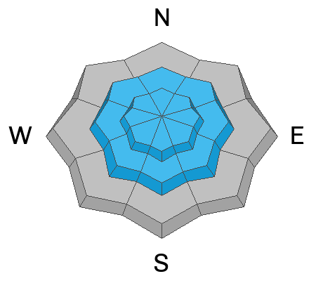
Today with new snow and strong winds from the south, the avalanche danger is CONSIDERABLE at upper elevations where you'll likely trigger meaty slabs of wind drifted snow. The danger at mid elevations is MODERATE and human triggered avalanches are definitely possible on any wind loaded slope.

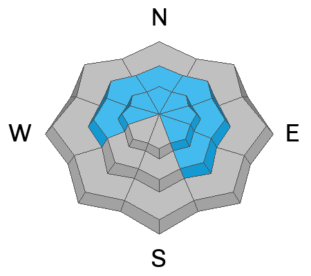
At low elevations below 8000 feet where there has been less new snow and less wind, the avalanche danger is LOW.
Low
Moderate
Considerable
High
Extreme
Learn how to read the forecast here
Weather and Snow
Since yesterday morning, snowfall amounts are 7 inches of dense snow containing 1 inch of water. Winds from the south at upper elevations yesterday averaged 35 mph with gusts up to 60 mph, and they were a bit gusty even at lower elevations yesterday afternoon.
This morning, temperatures are hovering near freezing and in the low 20s F at upper elevations. Winds this morning are blowing from both the south and southeast 15-25 mph gusting 30-40 mph (perfect speeds for transporting snow).
Today, winds should increase and blow 30 mph from the south and south-southwest gusting 50-60 mph. Temperatures will warm a bit at lower elevations but remain in the low to mid 20s F at upper elevations. Snowfall will return this afternoon with a few inches accumulating. More snow falls tonight with the heaviest snowfall around midnight. By tomorrow morning, there should be another 6-12 inches of new snow.
The National Weather Service has issued a Winter Storm Warning from tonight until Thursday morning with 12-24 inches of snow expected during that timeframe. Scroll to the bottom for an image showing expected snowfall amounts across the state.
Recent Avalanches
Ski patrols reported easily triggered slabs of wind drifted snow yesterday, and cat crews reported more of these wind slabs while grooming overnight. On Rocky Point near Alta yesterday, a skier triggered a wind slab a foot deep by 20 ft wide.
Additionally, avalanches breaking deeper on faceted layers continue to pop up. One yesterday broke 2 ft deep by 40 ft wide above the Hallway in Cardiff Fork. On Sunday a slide was triggered in Hidden Canyon in upper Big Cottonwood Canyon and in Days Fork.
Ad
Avalanche Problem #1
Wind Drifted Snow
Type
Location
Likelihood
Size
Description
Dense slabs of wind drifted snow are the main concern especially as winds from the south are expected to increase again today. It's a game of tug-of-war: these wind slabs are trying to stabilize and bond, but loading from continued strong winds will keep them on edge. I've been fooled many times by unreactive wind slabs on test slopes only to find other wind slabs that I have triggered.
I'd avoid any wind loaded slope today and give these dense slabs of wind drifted snow time to bond.

The avalanche in the video below was triggered in Lake Chute on Sunday. Today's wind slabs should be stiffer and break above you versus just below the skier in the video.
Video credit: Christoph
Avalanche Problem #2
New Snow
Type
Location
Likelihood
Size
Description
I suspect the warm dense snow is well bonded and avoiding any wind loaded slopes will be the key to avoiding avalanches. However, it's worth assessing the new snow. With an inch of water in the new snow, it could make a meaty soft slab avalanche. Check small, steep, test slopes; step or ride above the track from another person; and do a few snowpack tests to see how the new snow has bonded to itself and underlying layers.
Avalanche Problem #3
Persistent Weak Layer
Type
Location
Likelihood
Size
Description
Hard slab avalanches breaking on a buried persistent weak layer continue to occur sporadically and enough to spook me. They seem to be happening mostly in steep rocky areas with a thinner snowpack. The load of new snow plus the load of wind drifted snow will increases the likelihood of these avalanches. They won't be happening all over the place, but enough to cause me to be conservative in my terrain choices.
Here's the good news, snowfall this week is just what we need to help bury these layers even deeper and help them heal. The bad news is that we keep finding steep rocky areas with thin snow where the facets remain very weak and dry. In these places, these weak layers will need a lot of snow and a lot of time to heal. For me, I'm shelving my most ambitions terrain choices until maybe March or even April. We'll see.
Additional Information
If you trigger an avalanche in the backcountry, AND NO ONE IS HURT or needs help, please notify the nearest ski area dispatch to avoid a needless response by rescue teams. If someone is injured or you need help call 911.
Salt Lake and Park City – Alta Central (801-742-2033)
Canyons Resort/PCMR Dispatch (435 -615-1911)
General Announcements
This information does not apply to developed ski areas or highways where avalanche control is normally done. This forecast is from the U.S.D.A. Forest Service, which is solely responsible for its content. This forecast describes general avalanche conditions and local variations always occur.