Forecast for the Provo Area Mountains

Drew Hardesty
Issued by Drew Hardesty on
Wednesday morning, February 5, 2025
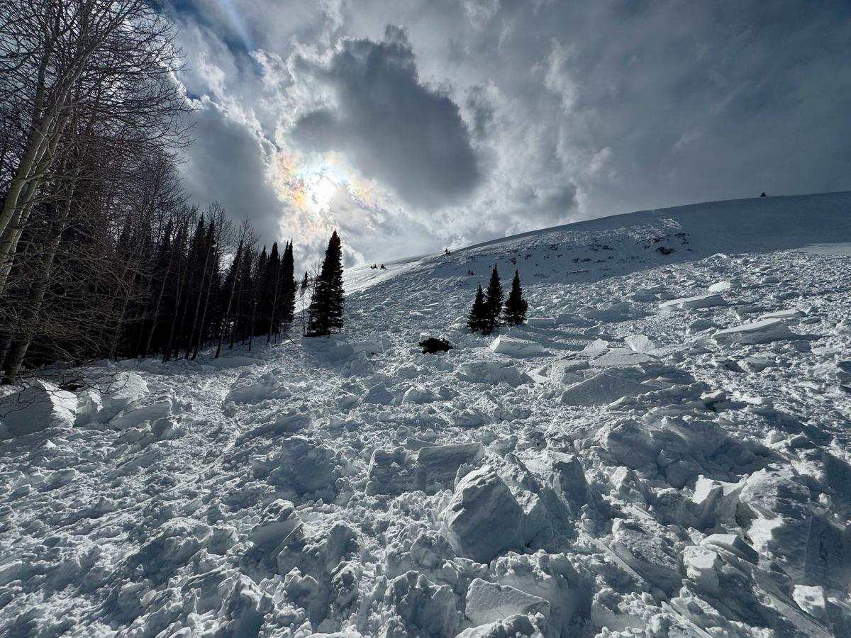
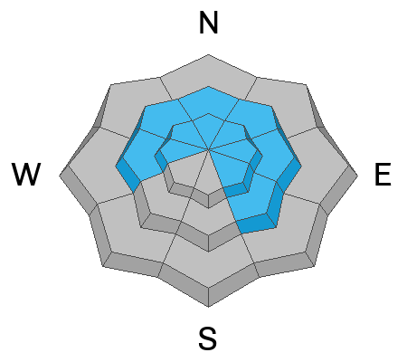
Areas of CONSIDERABLE avalanche danger exist for soft and hard slabs of wind drifted snow in steep wind loaded terrain. You are also likely to trigger wet loose or wet slab avalanches in the mid and lower elevations, primarily on the north side of the compass.
Please keep ROOF-AVALANCHES on your radar.
I have a lot of uncertainty in today's forecast. Extra caution is advised.
Low
Moderate
Considerable
High
Extreme
Learn how to read the forecast here
Special Announcements
The Preliminary Report for Monday's Monte Cristo avalanche fatality is HERE. (photo below from yesterday)
Our condolences go out to the victim's friends and family and all those affected by this tragic accident. UAC staff visited the site yesterday and a full report is forthcoming.
Weather and Snow
Skies are overcast ahead of today's weak storm. Temperatures remain way too warm - in the upper 30s to low 40s. Winds remain strong from the southwest.
For today, we'll have light snowfall that may add up to 1-3". Temps will drop slightly and slowly by late afternoon. Winds will remain moderate to strong from the southwest.
Another stronger and colder storm is on tap for Friday into Saturday that should really improve skiing and riding conditions. Currently the wind and warmth have made the riding condions rugged, at best.
Recent Avalanches
The ski area reported triggering wet loose avalanches which would in turn gouge out wet slab avalanches 1-2.5 feet deep, running on wet basal faceted grains. I imagine more of this today.
Ad
Avalanche Problem #1
Wind Drifted Snow
Type
Location
Likelihood
Size
Description
The winds remain merciless. Hard and soft slabs of wind drifted snow litter the steep terrain, although they are more stubborn and sluggish than late weekend into Monday. Many of these wind slabs, however, do rest upon a layer of weak recrystallized snow (last week's snow surface) and remain prone to triggering. It may be possible for any new wind slab to step down into weak faceted grains near the ground, particular in areas that avalanched previously this winter.
Cornices are becoming unruly along the ridgelines - remember to give these growing monsters a wide berth.
Avalanche Problem #2
Persistent Weak Layer
Type
Location
Likelihood
Size
Description
There are two buried persistent weak layers (PWL) in the snowpack:
  • The upper layer formed during last week’s cold, clear weather and many wind slabs are failing at this layer.
  • The lower layer, near the ground, formed in December and has caused large avalanches, including two fatalities during the Holiday Avalanche Cycle. This layer is most likely to be triggered on steep, thin snowpack areas, rocky gullies, and repeater slopes (areas that have previously avalanched). Avalanches up to 1–3+ feet deep possible.
Avalanche Problem #3
Wet Snow
Type
Location
Likelihood
Size
Description
The record warmth is wreaking havoc on an poorly structured snowpack. You can see the last decent refreeze was near the beginning of the month. Wet loose and wet slab avalanches are still likely today, despite the slightly cooler temps. I view the shady aspects to be most prone...and debris piles will be enough to catch, carry, and bury you.
General Announcements
This information does not apply to developed ski areas or highways where avalanche control is normally done. This forecast is from the U.S.D.A. Forest Service, which is solely responsible for its content. This forecast describes general avalanche conditions and local variations always occur.