Join us for the 17th Annual Professional Snow and Avalanche Workshop (PROSAW) on November 4 - Purchase tickets here!

Forecast for the Provo Area Mountains

Dave Kelly
Issued by Dave Kelly on
Tuesday morning, February 27, 2024
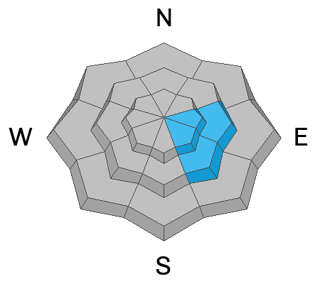
Today, there is a CONSIDERABLE avalanche danger on upper-elevation slopes where you are likely to trigger wind-drifted snow avalanches near ridgelines and terrain features; and at mid elevations facing east and southeast where you may trigger a persistent weak layer avalanche that breaks on facets above a crust 2'-3' deep.
The avalanche danger is MODERATE on other mid-elevation slopes and LOW at the lowest elevations.
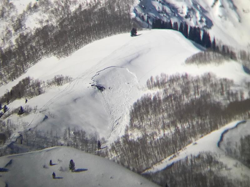
Strong overnight winds created fresh wind-drifts at upper elevations and new snow may be covering them. These wind-drifts may break above you 1'-3' deep; and can be avoided by choosing terrain out of the wind zone.
Low
Moderate
Considerable
High
Extreme
Learn how to read the forecast here
Special Announcements
We are seeking a passionate individual to join us as Executive Director of the nonprofit Utah Avalanche Center.
Weather and Snow
This morning, under overcast skies temperatures are in the teen's °F. Winds are blowing from the east 5 gusting to 15 MPH at 8,000', and west 25 gusting to 40 MPH at 8,800'. Wind chills are well below 0 °F. There was 3"-6" of new snow overnight with .30"-.45" of water.
Today, we can expect cloudy skies, winds blowing from the west 20 gusting to 30 MPH at the 9,000' ridgelines and west-northwest 40 gusting to 55 MPH at the 11,000' ridgelines. Temperatures should be 18°- 20°F. The Provo Area Mountains are forecast to see 1"-4" of additional snow and .05"-.25" of water today. Snow should taper off with clearing skies by later this evening.
Our Partners at the National Weather Service have issued a Winter Storm Warning effective until 5PM this evening with 10"-20" of total snow expected and gusty winds at higher elevations. Read more HERE.
Recent Avalanches
Yesterday, there was a close call with a group of 4 skiers involved in a wind-drifted snow avalanche on Little Water Peak in Big Cottonwood Canyon. We will update this report with more details as we gather information. We received a few observations noting wind-transported snow at the highest ridgelines, wet loose at low elevations, and reports of snow surfaces that were not as weak as expected in Aspen Grove.
Check out all recent observations HERE.
Ad
Avalanche Problem #1
Wind Drifted Snow
Type
Location
Likelihood
Size
Description
Underneath the newest snow you will find stubborn slabs of wind-drifted snow on upper-elevation slopes and terrain features. These drifts could be 1'-3' deep and break up to 150' wide. Watch for and avoid signs of wind-drifted snow; such as pillow-shaped deposits and rounded smooth areas of snow. Cracking in new wind-drifted snow is a sign that things are unstable and steeper slopes should be avoided.
Cornices are signs of wind loading leeward features. Any cornice failure could trigger an avalanche on the slope below and today I would give these new cornices some space as they may break further back from the ridgelines than you expect.
In some areas we did see weak surface snow prior to yesterday's wind event on steep northerly facing terrain. There will be isolated areas out of the wind zone where the new snow will not have bonded particularly well. Have an escape plan if loose surface snow picks up more speed as it can be more than enough mass to carry you off your feet. Any new wind-drifted snow on weak surface snow will be perched precariously waiting for an additional load before it cascades downslope. This could be more wind, snow, or a human trigger.
Avalanche Problem #2
Persistent Weak Layer
Type
Location
Likelihood
Size
Description
On east-southeast facing slopes at high and mid elevations there is a persistent weak layer (PWL) of facets just above a crust that was buried by new snow on or around February 14. Warm weather and clear skies over the last three days have decreased the likelihood of triggering an avalanche on this layer, and the facets will continue to heal. This problem is not on every slope and each slope facing east-southeast should be assessed individually before committing to terrain over 30° in steepness. New snow and wind on top of this layer may make it more likely to fail and any avalanches on this layer will be 2'-3' deep and a couple 100' wide.

We have been working on shrinking this problem as it appears to be primarily isolated to southeast through east-facing aspects.
Photo (UDOT Provo) of an avalanche that likely failed on this PWL on an east facing slope in the Snake Creek Drainage.
General Announcements
This information does not apply to developed ski areas or highways where avalanche control is normally done. This forecast is from the U.S.D.A. Forest Service, which is solely responsible for its content. This forecast describes general avalanche conditions and local variations always occur.