Join us for the 17th Annual Professional Snow and Avalanche Workshop (PROSAW) on November 4 - Purchase tickets here!

Forecast for the Provo Area Mountains

Dave Kelly
Issued by Dave Kelly on
Monday morning, February 26, 2024
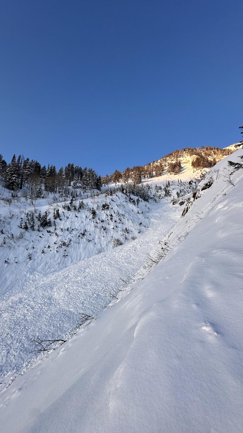
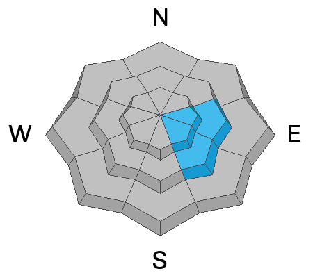
Today, there is a MODERATE avalanche danger on upper-elevation slopes where it will be possible to trigger wind-drifted snow avalanches near ridgelines and terrain features; and at mid elevations facing east and southeast where you may trigger a persistent weak layer avalanche that breaks on facets above a crust 1'-3' deep.
The avalanche danger may rise to MODERATE on other aspects and elevations later this afternoon with the approach of a new storm that is forecast to bring increased wind speeds, new snow and dropping temperatures to the area.
Low
Moderate
Considerable
High
Extreme
Learn how to read the forecast here
Special Announcements
We are seeking a passionate individual to join us as Executive Director of the nonprofit Utah Avalanche Center.
Weather and Snow
This morning, under partly cloudy skies temperatures are in the low to mid 30's °F. Winds are blowing from a southerly direction 20 gusting to 30 MPH.
Today, look for increasing clouds, winds blowing from the west-southwest 25 gusting to 35 MPH at the 9,000' ridgelines and 35 gusting to 55 MPH at the 11,000' ridgelines. Temperatures should be 39°- 42°F with a freezing level dropping throughout the day. Areas favored by southwest flow could see 2"-3" of snow and .10"-.15" of water by early evening. The frontal passage is forecast to come through around midnight with a drop in temperatures, and an increase in wind speeds with gusts up to 100 MPH, and widespread snowfall overnight.
Our Partners at the National Weather Service have issued a Winter Storm Warning effective from 11AM this morning through 11PM Tuesday night with 10"-20" of snow expected and gusty winds at higher elevations. Read more HERE.
Yesterday, I noted melt-freeze crusts on solar aspects and weak faceted surface snow on the northerlies. There was also snow being transported across the highest ridgelines starting to form stiffer wind drifts and these increased winds were starting to break down some of the surface hoar and near-surface facets that were observed earlier in the weekend. On shaded aspects, there is still soft snow. If you move into steeper terrain, remember that even a loose-dry avalanche can travel far. Have an escape plan if loose surface snow picks up more speed as it can be more than enough mass to carry you off your feet.
Recent Avalanches
Yesterday, Greg found a graupel avalanche in White Pine likely triggered by cornice fall. There was a catch and carry in Big Springs in the Provo Area Mountains involving wind-drifted snow. There was also a report from Aspen Grove of a soft slab avalanche that likely released on Friday (photo: A. Webb below).
Ad
Avalanche Problem #1
Wind Drifted Snow
Type
Location
Likelihood
Size
Description
Sustained strong winds since yesterday have created stubborn slabs of wind-drifted snow on upper-elevation slopes and terrain features. These drifts could be 1'-3' deep and up to 150' wide. Watch for and avoid signs of wind-drifted snow; such as pillow-shaped deposits and rounded smooth areas of snow. Cracking in new wind-drifted snow is a sign that things are unstable and steeper slopes should be avoided. Cornices are signs of wind loading leeward features. Any cornice failure could trigger an avalanche on the slope below.
As Greg found yesterday, some of these wind drifts may be reactive if they formed on top of graupel. The graupel layers vary, but they are often found below steeper cliff bands.
Avalanche Problem #2
Persistent Weak Layer
Type
Location
Likelihood
Size
Description
On east-southeast facing slopes at high and mid elevations there is a persistent weak layer (PWL) of facets just above a crust that was buried by new snow on or around February 14. Warm weather and clear skies over the last three days have decreased the likelihood of triggering an avalanche on this layer, and the facets will continue to heal. This problem is not on every slope and each slope facing east-southeast should be assessed individually before committing to terrain over 30° in steepness.

We have been working on shrinking this problem as it appears to be primarily isolated to southeast through east-facing aspects. Read more from my observation in Upper American Fork HERE which includes a list of the most recent avalanches failing on this layer.
Avalanche Problem #3
Wet Snow
Type
Location
Likelihood
Size
Description
Elevated winds should keep the wet snow at bay today in upper elevations. Many locations have not seen a refreeze since Saturday morning and these lower and mid elevation slopes are places where you may see wet avalanche activity. Wet snow is the easiest avalanche problem to avoid. Look for and avoid signs that the snow surface is becoming wet; such as rollerballs and pinwheels. If you are sinking into the snow past your boot tops it is time to gain elevation and find dryer snow. Any wet loose avalanches may trigger larger slab avalanches.
This problem will decrease with colder temperatures moving in this afternoon.
Additional Information
Mark discusses the PWL avalanche problem on east-southeast facing aspects in this video a close call on Miller Hill from late last week.

Many slopes in the Provo Area Mountains have avalanched a number of times this winter. These thinner (shallow) snowpack zones are the exception and not the rule and are places where you could trigger a large avalanche failing on dry facets near the ground. Check out all avalanche observations HERE.
General Announcements
This information does not apply to developed ski areas or highways where avalanche control is normally done. This forecast is from the U.S.D.A. Forest Service, which is solely responsible for its content. This forecast describes general avalanche conditions and local variations always occur.