Forecast for the Provo Area Mountains

Mark Staples
Issued by Mark Staples for
Wednesday, February 20, 2019
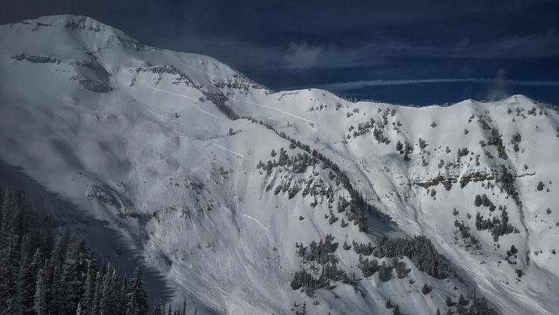
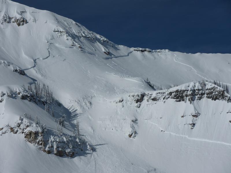
Today in the Provo area mountains, rating the avalanche danger is difficult. I am rating it CONSIDERABLE at mid and upper elevations on wind loaded slopes and aspects that have produced massive natural avalanches. Even though the likelihood of triggering one of these monsters is decreasing, the travel advice for this danger rating says:
"Dangerous avalanche conditions. Careful snowpack evaluation, cautions route finding, and conservative decision making essential."
The avalanche danger is MODERATE at mid and upper elevations generally on West through South aspects. The danger is LOW at low elevations.
Low
Moderate
Considerable
High
Extreme
Learn how to read the forecast here
Special Announcements
An AVALANCHE WATCH has been issues for the La Sal and Abajo mountains in southern Utah where the avalanche danger is expected to rise to HIGH. Strong winds with periods of heavy snow will create widespread areas of unstable snow. The avalanche danger in these mountains will remain elevated through the weekend.
Other parts of southern Utah where we don't issue avalanche forecasts may have an elevated danger as well. We do post obs from the mountains of southwest Utah. View them here or submit obs here.
Weather and Snow
Since yesterday morning 1-3 inches of very light snow has fallen.
This morning temperatures are in the single digits F. Winds increased are blowing 10-15 mph from the west and southwest. At 11,000 feet winds are gusting to 45 mph.
Today snowfall will continue with another 6 inches by tomorrow morning. Temperatures today will stay cold and should struggle to reach the teens F. Winds may ease a little bit and shift a little more southerly.
There is dry, soft snow on nearly all aspects and elevations. At lower elevations and south aspects there is a crust under about a foot of snow. On northerly aspects and higher elevations, the snow is deep and soft. There have been minimal winds the last few days.
Recent Avalanches
There was a very large natural avalanche that released within the past 36 to 72 hrs in the Provo area. This slide was 5-9' feet deep and up to 2500' feet wide, running 3,000' vertical feet to the valley floor. (PC: UDOT)
Ad
Avalanche Problem #1
Wind Drifted Snow
Type
Location
Likelihood
Size
Description
There is plenty of fresh powder for winds to transport. Winds should easily drift this new snow and form soft slabs but this shouldn't be a widespread problem. The best way to identify and avoid these fresh slabs is to look for them. They look pillowy, rounded and smoother than freshly fallen snow. They are often found on the opposite sides of ridges or other terrain features from places where the snow is scoured.
Some faceting seems to have occurred in recent days within the top foot of snow. I found some of these weak facets about a foot deep yesterday in Big Cottonwood Canyon and suspect they exists in the Provo area mountains. This layer could make any fresh slabs of wind drifted snow extra sensitive today and possibly fracture over wider than expected areas.
Avalanche Problem #2
Persistent Weak Layer
Type
Location
Likelihood
Size
Description
To be honest, I don't really know how I'd assess the snowpack in the Provo area mountains if I wanted to ride in avalanche terrain at mid and upper elevations on NW, N, NE, E aspects (and upper elevation SE). Recent natural avalanches have broken at the ground. With this type of avalanche it is very hard to assess what the likelihood of triggering one is. All we really know is that these slides have been MASSIVE and would be deadly to be caught in. The only mitigation strategy we have is to avoid avalanche terrain for now.
With such large cornices looming over many slopes, I'd would avoid run out zones. Cornices can break on their own and trigger more massive slides that could run down on top of you.
Photo: Zoomed in view of the natural avalanche that was spotted two days ago.
Avalanche Problem #3
Cornice
Type
Location
Likelihood
Size
Description
With so much snow falling in February and lots of strong winds, cornices have grown enormous. They will break back farther than you think, well back from the apex of the ridgeline. Exercise great caution along and underneath the heavily corniced ridgelines.
As mentioned above, falling cornices make excellent triggers for large avalanches breaking near the ground.
Additional Information
The accident reports for the four avalanche fatalities are all finalized with some first-hand accounts and worth reading. We all have something to learn so that we can get home safely to our loved ones. List of all accidents found HERE.
General Announcements
This information does not apply to developed ski areas or highways where avalanche control is normally done. This forecast is from the U.S.D.A. Forest Service, which is solely responsible for its content. This forecast describes general avalanche conditions and local variations always occur.