Donate to the 2024 Spring Campaign to help rebuild the UAC website.

Forecast for the Provo Area Mountains

Mark Staples
Issued by Mark Staples for
Thursday, December 6, 2018
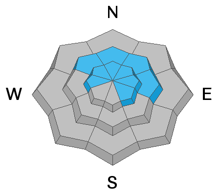
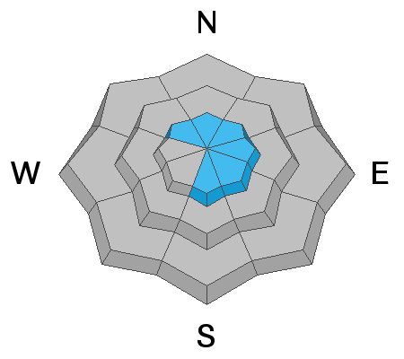
Today the avalanche danger remains CONSIDERABLE at mid and upper elevation northwest through east facing slopes where slab avalanches can break 2-4 feet deep at the ground on a persistent weak layer. A MODERATE danger exist on all other upper elevation slopes because some have this persistent weak layer and some have wind drifted snow. All other slopes have a LOW danger because they lack these avalanche problems.
Low
Moderate
Considerable
High
Extreme
Learn how to read the forecast here
Weather and Snow
Yesterday the main weather factor was increased southerly winds averaging 28 mph and gusting 48 mph at 8250 ft. Winds eased overnight, and are only blowing 7-15 mph from the WSW at 11,000 feet. Temperatures are surprisingly even across all elevations with most weather station reporting temps in the low 20s F.
Today under partly cloudy skies, temperatures will warm into the mid 20s F and winds will remain light. There is no promising weather on the horizon to bring more snow, but the good news is that there are no strong winds in the forecast either.
Snow depths are generally 2-3 feet deep. Sunshine over the last two days warmed slopes facing due south which should have a crust on them this morning.
Recent Avalanches
At one ski area yesterday in the Cottonwood Canyons, an avalanche triggered with explosives caused another one to release 300 feet away that was 4 feet deep. Another slide was triggered at the ground on a west facing slope near 10,000 feet. Avalanche activity at ski areas is important this time of year because the snowpack at ski areas is similar to the backcountry, and the Salt Lake area mountains so far seem to have similar conditions to the Provo area mountains.
Ad
Avalanche Problem #1
Persistent Weak Layer
Type
Location
Likelihood
Size
Description
Old October snow that was on the ground before Thanksgiving has become a persistent weak layer of sugary, faceted snow crystals. This layer has produced widespread slab avalanches since snowfall around Thanksgiving. The slab on top of this weak layer is now 2-4 feet thick. This avalanche problem is labeled "persistent" because it doesn't go away and takes a long time to heal.
I wouldn't touch any slope harboring this persistent weak layer. There are two ways to know if this layer exists. First is to know the direction (aspect) the slope faces. Second is to dig a quick snowpit on an adjacent low angle slope. If you find weak sugary snow at the ground, pick a different slope. You have to be a detective to determine which slopes have this old snow and which do not.
I'm rating the avalanche danger at CONSIDERABLE based on the travel advice which is "careful snowpack evaluation, cautious route-finding and conservative decision-making." ALSO, southerly winds drifted some snow onto northerly facing slopes yesterday and added just a little more stress to this weak layer.
Avalanche Problem #2
Wind Drifted Snow
Type
Location
Likelihood
Size
Description
Small slabs of wind drifted snow from yesterday's southerly winds can be found just under ridgetops. This isn't a widespread problem but worth looking for. As mentioned above, any wind drifting of snow onto slopes with a persistent weak layer problem will increase the odds of triggering a larger avalanche that will break near the ground.
General Announcements
This information does not apply to developed ski areas or highways where avalanche control is normally done. This forecast is from the U.S.D.A. Forest Service, which is solely responsible for its content. This forecast describes general avalanche conditions and local variations always occur.