


Forecast for the Provo Area Mountains

Issued by Dave Kelly on
Monday morning, December 12, 2022
Monday morning, December 12, 2022
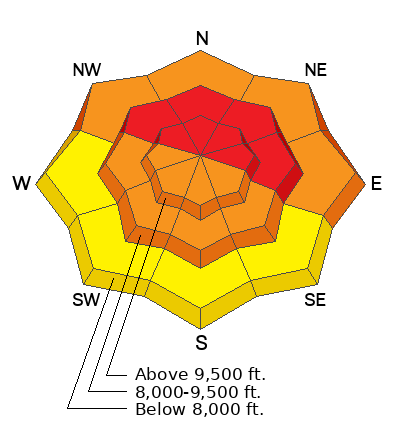
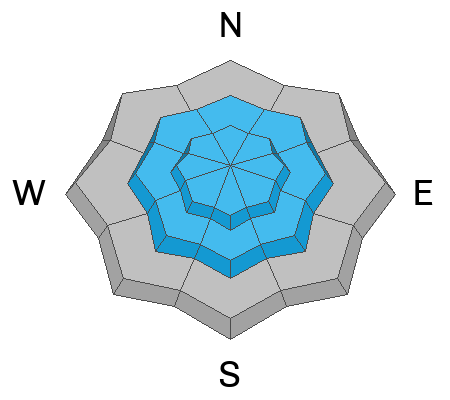
The avalanche danger is HIGH on mid and upper elevation northwest through east aspects where natural and human-triggered avalanches may break down 2-4' deep and over 200' wide, failing on a persistent weak layer of faceted snow. The avalanche danger is CONSIDERABLE at lower elevation northwest-east aspects and on mid and upper elevation west-southeast aspects. The avalanche danger is MODERATE at lower elevation west-southeast aspects.
Today is a day to avoid traveling on slopes over 30 degrees or connected to slopes over 30 degrees.
Low
Moderate
Considerable
High
Extreme
Learn how to read the forecast here
Special Avalanche Bulletin
STRONG SOUTHERLY WINDS, COUPLED WITH HEAVY SNOW OVERNIGHT HAS CREATED RISING AVALANCHE AVALANCHE DANGER OVER THE LAST 24 HOURS. LARGE, DANGEROUS AVALANCHES ARE LIKELY ON NORTHWEST-NORTH-EAST FACING AVALANCHE TERRAIN. AVOID BEING ON, UNDER, OR ADJACENT TO STEEP WIND-DRIFTED SLOPES AND TERRAIN STEEPER THAN 30 DEGREES.
 Weather and Snow
The National Weather Service has issued a Winter Storm Warning that will last through Tuesday at 5:00 pm.
It is currently snowing in the mountains. Mountain temperatures are in the the mid teens F. Southwesterly winds are blowing in the mid teens gusting to the low 20's MPH at the 9000' and 11,000' ridgelines.
Storm Totals: Provo Area Mountains 9-11" snow 1" water
For today we are expecting snow showers with up to 5" of snow throughout the day, temperatures from 23-27 F and 9000' ridgeline winds southwest 20 gusting to 30 MPH and 11,000" ridgline winds southwest 25 gusting to 45 MPH. Winds will shift to the west and decrease after noon.
 Recent Avalanches
Overnight there was a natural avalanche cycle reported from mid Little Cottonwood Canyon during periods of higher precipitation rates. I expect that there were more avalanches in other areas during the highest snowfall rates.
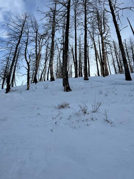
Skier Triggered avalanche on Friday, 12/9 in the Spanish Fork area. They were caught, carried, and partially buried against a tree. Details are limited, but you can find them HERE.

Avalanche Problem #1
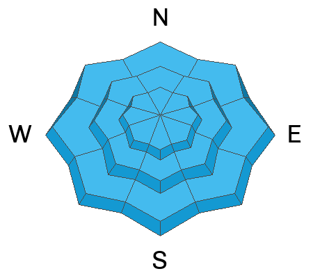
Persistent Weak Layer
Type
Location
Likelihood
Size
Description
There is plenty of weak sugary faceted snow (persistent weak layer) scattered on almost all aspects and elevations throughout the Wasatch Range. This persistent weak layer has now been buried under wind drifted snow in upper elevation terrain and capped by storm snow in the lower elevation wind protected areas. As we saw from the close call outside of Spanish Fork and from this observation in Snake Creek, I would be just as cautious in steep lower elevation terrain that harbors this weak layer.
However, what varies is the slab (the snow sitting above the weak layer). In sheltered locations, this slab might only be 10-15" inches deep, and in areas where the wind has loaded the slope, the slab could be anywhere from 1-4' feet deep and hard as a rock. In any case, we have dangerous avalanche conditions, and you can still trigger a season-ending slab avalanche failing on a persistent weak layer.
Avalanches are slightly less likely on solar aspects because of the prescence of ice crusts.
Today is not the day to tease this weak layer. The good news. This problem will go away with consistent snowfall. Remember, it's a long season, and it's shaping up to be an epic winter, don't ruin it now by getting injured or killed in an avalanche.
Avalanche Problem #2
New Snow
Type
Location
Likelihood
Size
Description
As of early this morning ski area patrol teams are reporting dry loose avalanches within the storm snow. This will be a short lived problem as new snow instabilities will settle out.
Avalanche Problem #3
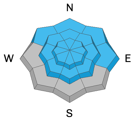
Wind Drifted Snow
Type
Location
Likelihood
Size
Description
These slabs of wind drifted snow can be soft or hard. The hard wind drifted snow might be camouflaged, look for stiff hollow drum like conditions under the new snow.
Be on the lookout for cross-loaded terrain features or drifts well off the ridgelines.
Remember, any wind slab avalanche that you trigger has the potential to step down into deeper weaker layers in the snowpack, creating a much more dangerous avalanche.
Additional Information
General Announcements
This information does not apply to developed ski areas or highways where avalanche control is normally done. This forecast is from the U.S.D.A. Forest Service, which is solely responsible for its content. This forecast describes general avalanche conditions and local variations always occur.