Forecast for the Provo Area Mountains

Drew Hardesty
Issued by Drew Hardesty for
Monday, December 11, 2023
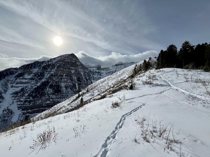
A MODERATE avalanche danger exists in much of the steep terrain of the mid and upper elevations. On westerly to northerly to easterly facing aspects it will still be possible to trigger an avalanche 1-4' deep stepping into the old faceted snow from early season. Cracking and collapsing may or may not accompany unstable slopes. Avalanches may still be triggered at a distance.
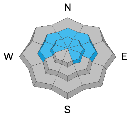
A LOW avalanche danger exists on many southerly aspects and on all low elevation slopes.
Low
Moderate
Considerable
High
Extreme
Learn how to read the forecast here
Special Announcements
Weather and Snow
Skies are clear to partly cloudy. Mountain temps are in the low 30s; winds are light from the west.
The Provo mountains have a thin snowpack so far with only 2-3' of settled snow depth. Riding conditions are fair on the sun and wind sheltered slopes.
For today, we'll have partly cloudy skies, light winds from the west and temps in the low to mid-30s.

The Outlook: fairly grim. Plenty of sun, seasonal to above seasonal temps, and light wind. Mike Seaman, the lead meteorologist this morning at the National Weather Service, describes Utah as moving into the "No-Flow-Zone". In other words, we're in limbo between the main storm track to the north and a weak system that dives to the south. I might be grasping at straws here, but perhaps we'll see a pattern change around the Solstice.
beautiful Provo mountains; pc: Talty
Recent Avalanches
We haven't heard of any recent avalanches in the Provo area mountains and avalanche conditions are slowly starting to improve.
Ad
Avalanche Problem #1
Persistent Weak Layer
Type
Location
Likelihood
Size
Description
The Provo mountains experienced a significant avalanche cycle last weekend (8 days ago give or take) but they did not pick up much snow from the most recent storm on Friday. Avalanche conditions are slowly stabilizing. Still, UAC education coordinator McKinley Talty and other observations by Trevor Katz and Mike Rossberg depict a conditionally unstable snowpack of strong over weak layering and unstable snowpit results. This warrants caution if heading into steep terrain today in areas that harbor old weak snow from October (west to north to easterly aspects of the mid and upper elevations).
Avalanche Problem #2
Wind Drifted Snow
Type
Location
Likelihood
Size
Description
Elevated winds from the west and northwest along the highest elevations should keep you alert to unstable soft slabs of wind drifted snow in steep terrain. Avoid smooth rounded scallops of soft slab in the highest elevations today. They should start to stabilize over the next day or two.
Additional Information

Idle Weather does the Devil's Work: Clear skies over the next several days will start to weaken the surface snow on the sun sheltered aspects, developing our potentially next weak layer.
UAC Education Coordinator McKinley Talty's haiku from fieldwork in Provo yesterday:
❄️
Poor structure afoot
Tipping point looming ahead
Where will you be then?
General Announcements
This information does not apply to developed ski areas or highways where avalanche control is normally done. This forecast is from the U.S.D.A. Forest Service, which is solely responsible for its content. This forecast describes general avalanche conditions and local variations always occur.