Forecast for the Provo Area Mountains

Drew Hardesty
Issued by Drew Hardesty for
Tuesday, December 11, 2018
The avalanche danger is MODERATE on upper elevation slopes facing west through southeast, and on mid elevation northwest through east facing terrain. Human triggered avalanches 2-4' deep are possible in this terrain. These are potentially unsurvivable avalanches. Isolated areas of wind drifted snow should also be avoided in steep alpine terrain. All other slopes have a LOW danger.
Low
Moderate
Considerable
High
Extreme
Learn how to read the forecast here
Special Announcements
Tonight at 6:30 p.m. at the Park City Library: Learn about the "Current state of the snowpack... how did we get here? and where are we going." 1255 Park Avenue, Park City, Utah. Presented by the Park City Professional Ski Patrol Association and the Utah Avalanche Center.

Check out the new free online avalanche course series developed by the Utah Avalanche Center. This is a great way to refresh your skills or prepare you for a Backcountry 101 or Level 1 class.
Weather and Snow
I guess if you blinked, you'd never know a weak weather system moved through overnight, but sure enough. Skies are clear and mountain temperatures with the weak cold front are in the upper mid-20s. The gusty southwesterlies veered to the west northwest overnight and are now blowing 10-15mph with gusts to 25. Current snow stakes sit at 25-35". With a week since the last snowfall, I'll admit the snow is getting a bit rough around the edges: supportable to breakable crusts on the southerlies and wind effect and hard wind-whales in the high alpine. The good news is that soft settled powder exists in the sheltered, shady terrain. It's not really powder snow, per se, but recrystallized snow, faceted snow. A man of boundless curiosity, Peter Donner looked into the origins of the word facet and found, Origin: Early 17th century: from French facette, diminutive of face ‘face, side’ (see face). The working definition is more subtle, "One side of something many-sided, especially of a cut gem." Indeed they are beautiful, facets. We'll be keeping an eye on the surface facets and any lingering surface hoar with tomorrow's quick hitting storm.

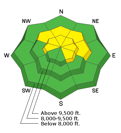
Tomorrow's quick hitter at the very least will sweep the smog out of the valleys and probably produce 2-5" of true powder for the mountains. It's a sharp looking cold front with mountain temps dropping to the upper single digits and a wind shift to the northwest. Post-frontal winds, however, look to remain moderate to strong until evening.
Recent Avalanches
On Saturday, a skier was caught, partially buried, and injured in an avalanche in the central Wasatch. It was in upper Porter Fork of Mill Creek Canyon (NW aspect, 9500 feet, 45 degree slope angle). The avalanche was confined by terrain and was only about 30 ft wide but ran 600 feet vertical. He was the second person on the slope and it broke about 100 ft above him. He was able to hike out under their own power but one ski was broken in half. Read more details HERE.
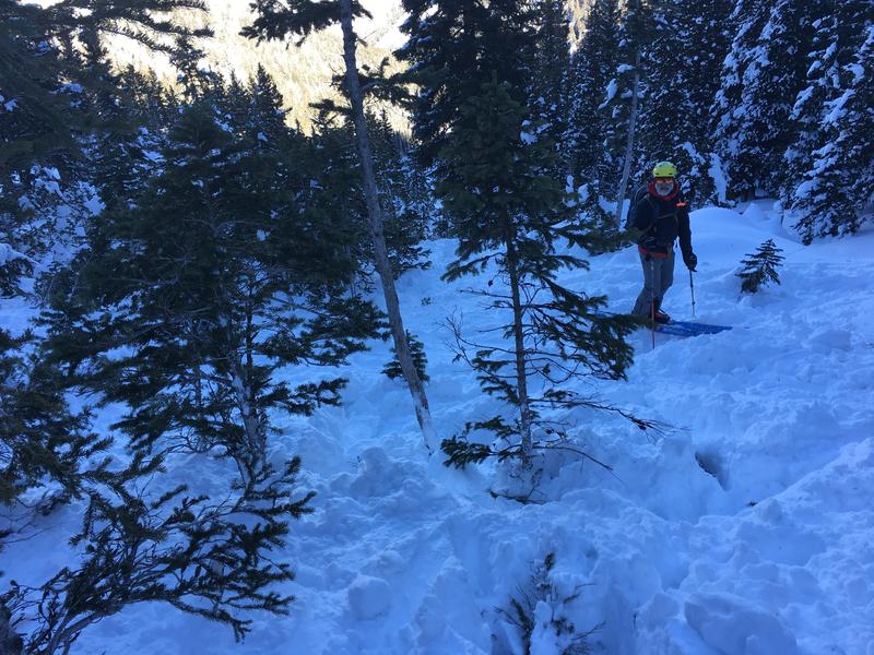
In the photo below, Paul Diegel - long time (and recently retired) executive director of the UAC - looks down at where the captured skier came to rest, partially buried around these trees in the runout zone,
Ad
Avalanche Problem #1
Persistent Weak Layer
Type
Location
Likelihood
Size
Description
A persistent weak layer of sugary, faceted snow crystals is buried under a slab 2-4 feet thick. The skier triggered avalanche on Saturday slid on this layer and over two-thirds of our avalanche fatalities involve similarly structured snow with facets like these. About a week ago, avalanches and collapsing were widespread but are now isolated occurrences. This layer is most likely to produce an avalanche at upper elevation slopes facing NW, N, NE and E which had the thickest layer of old snow.
There are many slopes where one might get away with it but there are many where you won't and there are nuances in the snow structure due to slight aspect change that can turn a green light red. It's what led pro observer Mark White to bail two-thirds the way up Bonkers in Broads Fork of BCC yesterday. His observation is worth a read. You can find his and many other observations in the menu bar at the top under Observations and Avalanches.

So What to Do? Mark Staples has a good list of options below. They were in his forecast yesterday and I think worth a repeat:
  1. Ride south-facing slopes where this layer doesn't exist.
  2. Ride slopes less than 30 degrees in steepness where avalanches generally don't happen.
  3. If riding northerly facing slopes that are steep enough to slide, choose ones with a clean run-out free of trees and rocks.
  4. Dig a snowpit. Digging a snowpit may not provide all the answers but it does provide an opportunity to slow down and allow for conversation and decision making among group members.
Avalanche Problem #2
Wind Drifted Snow
Type
Location
Likelihood
Size
Description
Yesterday's gusty winds led to some wind slab development along the highest, most exposed ridgelines. Continue to look for and avoid fresh deposits of wind drifted snow.
General Announcements
This information does not apply to developed ski areas or highways where avalanche control is normally done. This forecast is from the U.S.D.A. Forest Service, which is solely responsible for its content. This forecast describes general avalanche conditions and local variations always occur.