Forecast for the Provo Area Mountains

Mark Staples
Issued by Mark Staples on
Thursday morning, January 30, 2020
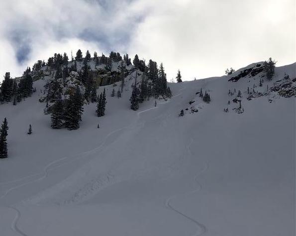
Today at upper elevations, the avalanche danger is MODERATE.
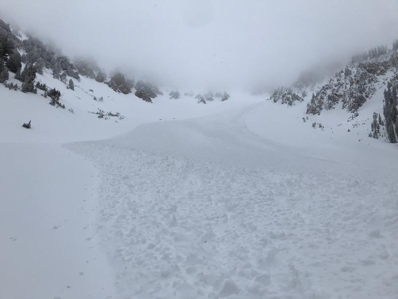
Winds increased overnight after being fairly calm yesterday. Watch for fresh slabs of wind drifted snow. People have triggered slides at upper elevations over the last few days.
At mid and low elevations, conditions are generally safe and the danger is LOW.
Low
Moderate
Considerable
High
Extreme
Learn how to read the forecast here
Special Announcements
Discounted lift tickets - Thanks to the generous support of our Utah ski resorts and Ski Utah, all proceeds from these ticket sales go towards paying for avalanche forecasting and education! Get your tickets here.
Weather and Snow
Yesterday had clouds stuck over many areas with just a trace to one inch of snow falling. Winds were mostly light through the day. This morning, winds at upper elevations are blowing 10-20 mph and gusting 20-40 mph from the W and NW. At mid elevations, winds are blowing 5-10 mph. Temperatures are in the teens to low 20s F.
Today skies will be mostly cloudy with another chance for about an inch of snow. Winds will remain elevated compared to yesterday but will mostly be confined to upper elevations. Temperatures should climb into the upper 20s F.

Great riding conditions exist on most slopes. The powder is dense but fun, fast, and surfy on all aspects and elevations.

Making plans for this weekend? - Strong sunshine and very warm temperatures will make the snow wet on south aspects and low elevations. Get an early start if headed out on Saturday. Starting Sunday night going into Monday, very cold temperatures and decent snowfall arrive.
Recent Avalanches
There were two reported avalanches yesterday. One was on Little Superior on a south aspect about a foot deep that ran on top of a buried ice crust. Another was on a north aspect nearby in Days Fork that was 18 inches deep and 200 feet wide.
On Tuesday, a sizeable avalanche was noted in Northwest Couloir near Mount Nebo (photo below). This was avalanche ran all the way down the bowl and reached the flats below, leaving damaged small pine trees and a large debris pile. This avalanche looked to occur in the wind drifted snow and most likely occurred sometime Monday naturally.
Ad
Avalanche Problem #1
Wind Drifted Snow
Type
Location
Likelihood
Size
Description
Soft slabs of wind drifted snow are the main avalanche problem to look for today. Fortunately, these wind slabs are easy to identify visually which makes them easy to avoid. Increased winds overnight at upper elevations drifted more snow and will keep these wind slabs possible to trigger today.
Recent avalanche activity is a good indication of what to expect today like one in the photo below (J. Collett) from Cardiff Peak on Tuesday.
Additional Information
On many slopes the danger is low, but this doesn't mean avalanches are impossible. It just means they are unlikely. Under these conditions, make a plan before you blindly ride a slope. Many slopes will have wind drifted snow just at the top or sometimes just one side. Avoid those sections and you can avoid avalanches.
Yesterday Bruce Tremper and I found a layer of graupel that had pooled underneath some rock slabs in Neffs Canyon. This layer seemed strong, but we don't like taking chances. We simply skied a short distance away from the rock slabs in the trees where this layer didn't exist.
Small variations in where you ski are ride can mean triggering an avalanche or not.
General Announcements
This information does not apply to developed ski areas or highways where avalanche control is normally done. This forecast is from the U.S.D.A. Forest Service, which is solely responsible for its content. This forecast describes general avalanche conditions and local variations always occur.