UDOT PLANNED AVALANCHE CLOSURES!!

Forecast for the Provo Area Mountains

Greg Gagne
Issued by Greg Gagne for
Tuesday, January 22, 2019
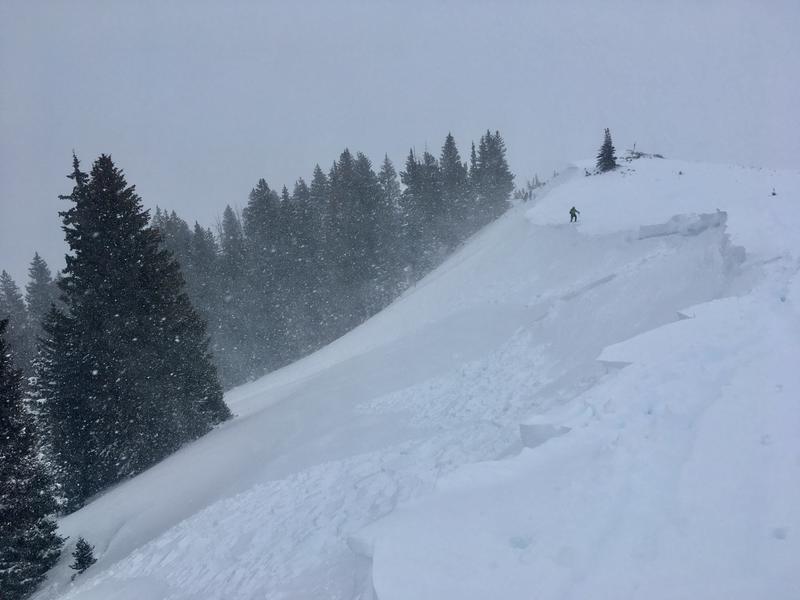
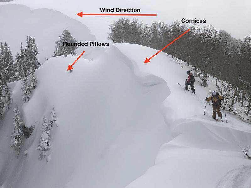
The avalanche hazard is HIGH at upper elevations and mid elevations facing north through southeast, and CONSIDERABLE at mid elevations facing northwest through south as well as low elevations. The primary avalanche concerns are fresh wind drifts and storm snow, especially at the upper elevations and areas that received the most snow such as Little Cottonwood Canyon. Avoid slopes steeper than about 30 degrees and avoid avalanche runout zones.
The majority of avalanche fatalities in Utah have occurred with a Considerable hazard rating. Don't be fooled by evidence of stability today. Since this past Wednesday the Provo mountains have received nearly 5" of water weight, and the snowpack needs time to adjust. Patience is the name of the game.
Low
Moderate
Considerable
High
Extreme
Learn how to read the forecast here
Special Announcements
On Friday, a skier was killed in an avalanche near Electric Lake on the Manti/Skyline Plateau. Their body was recovered Saturday morning. You can read the updated report - including photos and video from the accident site - by clicking here. The UAC extends our deepest condolences to their family and friends.
Weather and Snow
Storm totals for the Provo mountains are roughly 1' with 1" of water.
Temperatures this morning are in the low teens, and winds are out of the north/northwest, gusting in the teens. Temperatures today will be in the teens with partly cloudy skies.
Winds are forecasted to increase overnight, ahead of a weak system which should deliver a few inches of snow later Wednesday. Another similar weak system is possible this weekend.
Recent Avalanches
No avalanche activity was reported from the Provo mountains on Monday. Further north in the Salt Lake mountains, there was widespread natural avalanche activity yesterday, especially during the height of precipitation around midday. These were both storm slabs and long-running sluffs in the new snow. Human triggered avalanches were also reported, including very sensitive storm and wind slabs 1-2’ deep and 50’ wide (excellent observation by Grainger/Young). At the onset of the storm early yesterday, two skiers unintentionally triggered an avalanche on south-facing Emma Ridge and were briefly caught and carried, with fortunately no injuries (observation).
With partial clearing today, we hopefully will get a better sense of the extent of yesterday's avalanche activity as I am expecting there was some natural avalanche activity from the Provo mountains. [pc: Grainger]
Ad
Avalanche Problem #1
Wind Drifted Snow
Type
Location
Likelihood
Size
Description
Persistent northwest winds drifted snow at the upper elevations on Monday, as well as some mid-elevation locations. With Monday's storm, loose snow is available for transport, today's winds will possibly create fresh drifts, especially along exposed upper elevation ridgelines. Two observations from Monday in the Salt Lake mountains indicated sensitive wind drifted snow, including remotely triggering (from a distance) fresh wind slabs, as well as sympathetic releases (where one avalanche triggers another.) Avoid these fresh wind drifts by watching for evidence of recent wind drifted slopes such as rounded pillows of snow. Also avoid fresh cornices along ridgelines, especially on aspects facing north through southeast.
The photo below illustrates the windward direction (from right to left) which creates fresh cornices along the ridgeline, as well as rounded pillows of snow on the lee side of the windward ridges.
Avalanche Problem #2
New Snow
Type
Location
Likelihood
Size
Description
Although the Provo mountains only recorded 8-12" of snow from Monday's storm, you may find sensitive storm slabs, especially at the upper elevations that received the most snow, as well as dry, loose sluffs.
Finally, clouds, cool temperatures, and winds should keep the snow surface cool, but watch for any evidence of warming on solar aspects including rollerballs and wet, loose sluffs.
Avalanche Problem #3
Persistent Weak Layer
Type
Location
Likelihood
Size
Description
While the faceted weak layers in the snowpack are slowly adjusting to the new load, there has been so much heavy snow and wind drifting over the past week they can’t be trusted yet. You can trigger a deep slide on one of the buried facet layers on a steep slope, especially in areas with a shallow snowpack, including slopes that have slid one or more times this year and some mid elevation slopes. Any shallower, new snow slide or triggered wind drift may “step down”, breaking on one of these deeper weak layer, resulting in a large, dangerous slide.
Additional Information
Thanks to all snow safety workers on Monday including UDOT and professional snow safety teams at the resorts!
General Announcements
This information does not apply to developed ski areas or highways where avalanche control is normally done. This forecast is from the U.S.D.A. Forest Service, which is solely responsible for its content. This forecast describes general avalanche conditions and local variations always occur.