Forecast for the Provo Area Mountains

Greg Gagne
Issued by Greg Gagne for
Friday, January 19, 2024
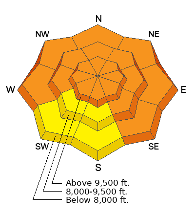
The avalanche danger is CONSIDERABLE at the upper elevations and lower and mid-elevation slopes facing west through north through southeast. The danger is MODERATE on lower and mid-elevation slopes facing south and southwest.
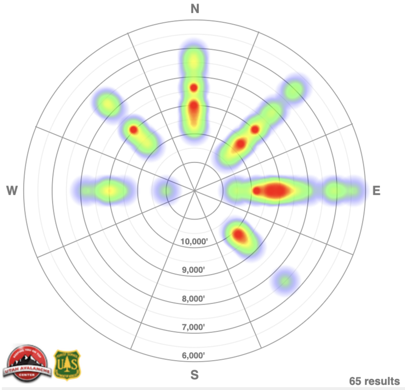
Avalanches may be large and destructive failing in a buried persistent weak layer, breaking down 3-5' deep and well over a hundred feet wide.
What to do: Avoid being on, underneath, or next to slopes steeper than 30°. Fortunately, there are plenty of lower-angled options where Wednesday's dense snow has created excellent riding and travel conditions.

With warm temperatures forecast, watch for wet-loose avalanches on steep sunny slopes and at lower elevations.
Low
Moderate
Considerable
High
Extreme
Learn how to read the forecast here
Special Announcements
Warm temperatures will likely lead to an increase in roof avalanches (or roof-alanches) where roofs shed their entire snowpack. UAC forecaster Dave Kelly noted this roofalanche at Alta on Thursday morning. These avalanches can be dangerous, so please keep in mind where children may be playing in the snow or adults moving snow and avoid being underneath any roof with covered with snow.
Weather and Snow
This morning: Temperatures have warmed overnight and range through 20's F. Winds are from the west/northwest and light, gusting in the teens up to 10,500' with gusts at the upper-most elevations in the 20's mph. South-facing slopes will be crusted.
Today: Partly sunny skies will give way to clouds this afternoon, with temperatures rising into the 30's and low 40's F. Winds will be from the west and remain light, with gusts in the 20's mph at upper elevations.
This Weekend: Our active January continues, although the southwest flow will bring mild temperatures and denser snow. Snow totals through the weekend will be 3-6". Another small system is expected around Tuesday.

Recent Avalanches
In the Salt Lake mountains, a rider was caught and carried in the Brighton backcountry on Thursday, partially buried to their chest in an avalanche 2' deep and 150' wide. The slide was on a northeast aspect at 9,000'.
Our avalanche heat map for the Provo, Salt Lake and Ogden mountains - which shows avalanche activity by aspect and elevation - over the past week is below. Notice the widespread activity on most aspects and all elevations.
Be sure to check all the avalanche activity HERE.
Ad
Avalanche Problem #1
Persistent Weak Layer
Type
Location
Likelihood
Size
Description
The widespread persistent weak layer (PWL) can be found on essentially all aspects and at all elevations. Although the PWL is slowly becoming more stubborn to trigger, human-triggered avalanches failing on this PWL remain likely on steep slopes. Avalanches could be triggered while you on the slope, but also underneath or on lower-angled slopes that are adjacent (or next to) steeper slopes. Any avalanche failing on this PWL will be 3-5' deep and well over a hundred feet wide.
Wednesday's storm containing strong winds and well over an inch of water further stressed this PWL and it simply needs more time to adjust.
I remain in a mindset of stepping back and continuing to avoid slopes steeper than 30°.
General Announcements
This information does not apply to developed ski areas or highways where avalanche control is normally done. This forecast is from the U.S.D.A. Forest Service, which is solely responsible for its content. This forecast describes general avalanche conditions and local variations always occur.