Join us for the 33rd Backcountry Benefit - Get Your Tickets Now!

Forecast for the Provo Area Mountains

Drew Hardesty
Issued by Drew Hardesty on
Thursday morning, January 15, 2026

Most terrain has an overall LOW avalanche danger. Pockets of MODERATE exist in the high alpine terrain for triggering a stubborn hard slab of wind drifted snow...or triggering a hard slab that steps to the ground 2-4 feet deep. This latter issue is limited to very isolated, steep, thin, rocky terrain on high elevation, northerly facing slopes.

Small but predictable wet loose avalanches may release during the day on sunny slopes with daytime warming.

Low
Moderate
Considerable
High
Extreme
Learn how to read the forecast here
Weather and Snow

Skies are clear.

As of 5AM, mountain temps are in the mid to upper-30s up high, the low 20s down low. Winds from the northwest have increased overnight, blowing 15-20mph with gusts to 25. Along the highest peaks and ridgelines, hourly wind speeds are 30mph with gusts to 50.

A couple of weak storms passing to the north and east of us over the next few days will bring slightly cooler temperatures and moderate to strong winds out of the northwest. Other than that, the song remains the same and it ain't rock and roll. It's the blues.

You have to walk aways, but travel is easy and supportable once you hit the the mid and upper elevations. And the views are spectacular in the high country,

Recent Avalanches

No reports of recent avalanches in the Provo mountains, but a large natural ripped out last weekend in Stairs Gulch of Big Cottonwood Canyon. Some terrain in Provo is similar: Provo Peak, Timp, Box Elder, etc.

  • A large natural avalanche in Stairs Gulch on a northwest aspect at 10,100 feet was reported. The avalanche was up to 5 feet deep and more than 300 feet wide, failing on faceted snow near the ground.

Natural avalanche in Stairs Gulch on Saturday; pc: Bo Torrey

Avalanche Problem #1
Persistent Weak Layer
Type
Location
Likelihood
Size
Description

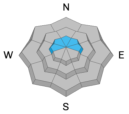
You may still be able to trigger a large avalanche to the ground in steep, rocky terrain in the highest elevations on the north side of the compass.

I wish I could sweep the Stairs Gulch avalanche from last weekend under the rug, but I can't. Some areas in high northerly terrain harbor a thin snowpack that has seen a fair bit of snow and wind since early January....with some avalanches stepping to the ground.

What it means is that you should exercise caution in (or avoid altogether) similar terrain; ie - areas of Box Elder, Provo Peak and Timpanogos. To name a few. You should also know that there will be no signs of instability such as cracking and collapsing. It's only knowing that poor structure and areas of unstable snow exist in isolated terrain, waiting.

Trend: Decreasing Danger

Avalanche Problem #2
Wind Drifted Snow
Type
Location
Likelihood
Size
Description

You may also find old and developing stubborn hard slabs of wind drifted snow in the alpine. Unfortunately, they have a nasty habit of breaking above you once you're on to the teardrop.

General Announcements

This information does not apply to developed ski areas or highways where avalanche control is normally done. This forecast is from the U.S.D.A. Forest Service, which is solely responsible for its content. This forecast describes general avalanche conditions and local variations always occur.