Forecast for the Provo Area Mountains

Greg Gagne
Issued by Greg Gagne for
Friday, January 12, 2024
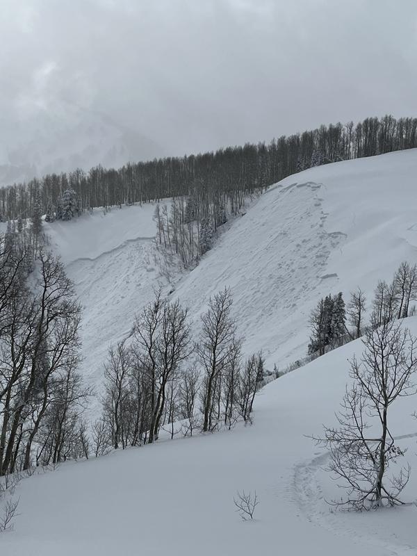
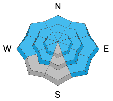
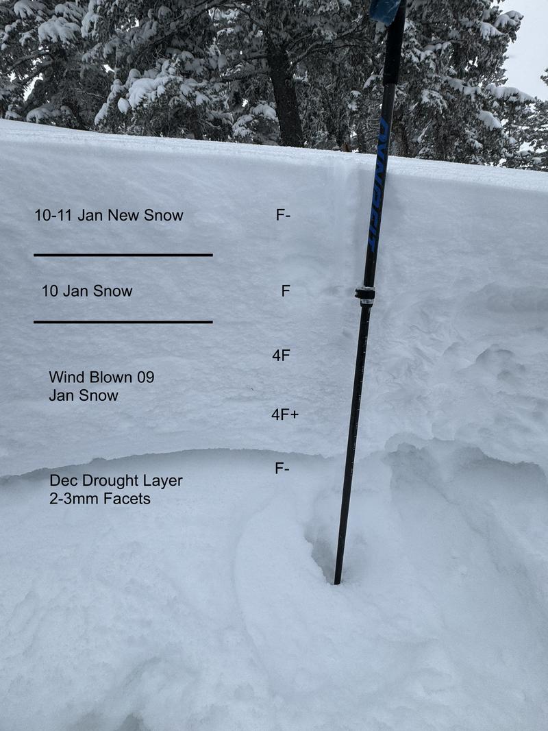
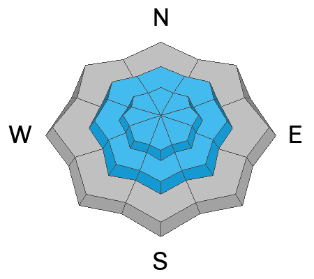
Dangerous avalanche conditions exist with a HIGH danger at mid and upper elevations and a CONSIDERABLE danger at lower elevations. Avalanches may fail 2-3' deep and hundreds of feet wide on a widespread persistent weak layer at all elevations.
Do not travel in avalanche terrain - do not be on, underneath, or adjacent to slopes approaching 30° or steeper.

With strong winds and several feet of snow forecast for this weekend, the avalanche danger is expected to increase.
Low
Moderate
Considerable
High
Extreme
Learn how to read the forecast here
Avalanche Warning
The avalanche danger for the warning area is HIGH for the mountains of northern and central Utah and southeast Idaho, which includes the Wasatch Range...the Bear River Range...Uinta Mountains...Manti-Skyline plateau...and the Mountains of Southwestern Utah.
Strong winds and heavy snowfall have created dangerous avalanche conditions. Avalanches failing on a widespread persistent weak layer buried under the new snow are very likely. Stay off of and out from under slopes steeper than 30°.
This avalanche warning is in effect from Friday, January 12, 2024 - 6:00am to Saturday, January 13, 2024 - 6:00am
Weather and Snow
As of 6 am, temperatures are in the single digits F, and winds are from the southwest through northwest, gusting into the 30's mph between 9,500' and 10,500'. At 11,000' wind gusts are in the 70's mph. 2-5" of snow (containing 0.25-0.5" of water) has fallen overnight.
For today, temperatures will rise into the teens F and winds will be from the west/northwest and strong. At the mid-elevations, winds will gust into the 40's and 50's while upper-elevation winds will gust into the 70's, perhaps even stronger this afternoon. An additional 5-10" of new snow is expected by sundown.

Looking ahead, the National Weather Service has issued a Winter Storm Warning through 5 pm Sunday, with strong winds and several feet of snow.
Recent Avalanches
With nearly 20 avalanches reported from the mountains of Ogden, Salt Lake, and Provo, to say Thursday was an active day is an understatement. These avalanches were both natural and human-triggered, with many remotely-triggered from adjacent ridgelines. Most were on aspects facing north through east, but also northwest and southeast. Reports of collapsing on southerly aspects were reported as well. Elevations ranged from 7,500' through 10,500'. Avalanches were up to 2' deep and 500' wide, failing in the persistent weak layer that formed during the December drought. You get the picture. You can peruse recent avalanche activity by clicking here.
A few region-wide highlights (* human caught and carried) :
- Natural avalanche cycle on South Timpanogos and there were several reports of natural and remotely-triggered avalanches in the Snake Creek and Ant Knolls regions.
In the Salt Lake mountains:
- West Will Ridgeline 2' deep 500' wide (photo below).
- Beartrap* (yes, Beartrap) 2' deep 80' wide.
- Yellowjacket* 1' deep 100' wide
- George's Bowl* 2' deep 150' wide
- Summit Park 1.5' deep 150' wide
One thing that stands out to our forecasting team is that some of the recent avalanche activity has occurred in terrain we generally consider "safe".
Ad
Avalanche Problem #1
Persistent Weak Layer
Type
Location
Likelihood
Size
Description
Strong winds and heavy snowfall have overloaded a widespread persistent weak layer (PWL) that is now buried about 2' deep. Most avalanche activity on Wednesday and Thursday occurred on this PWL, with both natural and human-triggered avalanches, many being triggered remotely (from a distance).
With strong winds and heavy snowfall forecast, avalanches failing on this PWL will only become larger.
The photo below (Brackelsberg/Paradis) shows the depth of this PWL and the slab on top.
Avalanche Problem #2
Wind Drifted Snow
Type
Location
Likelihood
Size
Description
With plenty of loose snow available for transport, strong winds will create slabs of wind-drifted snow at the mid and upper elevations. Strong winds such as this can work around terrain features, so you can expect to find fresh, sensitive wind drifts on any aspect. Triggering an avalanche in this wind-drifted snow is likely to step down into the PWL, creating a much larger avalanche.
Additional Information
Check out a forecaster discussion Mark and I had diving deeper into the forecast and how we will travel in the backcountry with a buried PWL

Check out this video Craig Gordon put together talking about the 5 red flags we use to determine if there is unstable snow.
1. Recent Avalanches
2. Cracking and Collapsing
3. Strong Winds
4. Heavy Snowfall
5. Rapidly Rising Temperatures
General Announcements
This information does not apply to developed ski areas or highways where avalanche control is normally done. This forecast is from the U.S.D.A. Forest Service, which is solely responsible for its content. This forecast describes general avalanche conditions and local variations always occur.